Sunday, 7 June 2015

May 2015 Review - Jyväskylä

Jyväskylä saw a cool May in 2015. The typical first burst of summer just never came. It was the coldest May, in fact, since 2008 at Jyväskylä Airport. The cooler temperatures weren't seen during the nights, but during the days, as maximums were well below figures from recent years.

Jyväskylä wasn't the only location in Finland to endure an extended spring. Almost all of the southern half of the country experienced below average temperatures. The southern coast and inland between Helsinki and Turku saw the biggest difference below average; up to 1.5C. Parts of Lapland, however, especially in the east, were slightly more than 1C above average.

Rainfall was above average at Tikkakoski, but there was very little storm activity throughout Finland during the month.

May figures from the previous seven years are shown below.

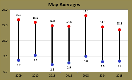
May averages at Jyväskylä Airport for the period 2009-2015

With an average maximum of 13.5C, May this year was 4.6C cooler than the May of 2013, and 1C cooler than the next coolest figure from last year. The Finnish Meteorological Institute recorded an overall average of 8.7C for the month, against 8.5C from my recordings. The 8.7C figure was the first below the 1981-2010 average of 8.9C since 2008.

The highest recording of the month at Tikkakoski came on May 25 when it reached 18.9C. This was well below figures from recent years. The next lowest respective figure since 2009 is 22.4C in 2011, while 2009, 2010, 2013 and 2014 all recorded days above 25C. The coldest maximum was also the lowest seen in May in the years since 2009. May 2 reached only 5.1C, just below 2014's 5.2C on May 4.

The highest minimum of 10.0C on May 27 was above the respective recordings from 2011 and 2012, but still quite far below last year's 14.1C and 2010's 15.2C. The coldest temperature overall was recorded on the 4th. The -3.0C recording then was one of only two minimums below zero during the month, and sits in the middle of the past seven years.

Extremes in Finland for the month ranged from -12.4C at Enontekiö's Näkkälä station on May 5 to Mikkeli's top of 21.7C on the 26th. The absence of any hellepäivät, or days above 25C, was the first instance for a May since 1998.

Daily minimums and maximums against rainfall for May at Jyväskylä Airport

Rain measured 53.6mm at Tikkakoski during the month. FMI recorded a total of 51mm. Both figures are above the 1981-2010 average of 44mm, but well below last year's 124.6mm, which was only just below the overall record.

May 13 was the wettest day when 22.7mm fell. It was also the wettest day of the year to date, and only the second day of the year with a total above 10mm. There were 20 days of precipitation, but the 14th of the month was the only other day to see more than 5mm. It was also part of a 10 day rain streak. Dry weather during the month was scarce. The longest dry streak was only two days, which occurred three times.

Despite the high number of rain days and the whole country recording above average rainfall totals, storm activity was rare. FMI reported only 331 groundstrikes. This is the third lowest figure for a May since 1960. In comparison, FMI reported over 25,000 lightning strikes for May in 2014.

Tuesday, 2 June 2015

May 2015 Review - Sydney

May in 2015 at Sydney Airport saw average temperatures a little closer to the long term figures when compared against the previous two years. They were still higher than average though. Rainfall was more than four times last year's figure, and the month was the wettest May of the past few years, but it still fell short of the average.

May averages since 2009 are shown below against the long term values.

May averages at Sydney Airport for the period 2009-2015 plus the long term average

Other than 2011, Sydney Airport hasn't seen an average minimum for May below the long term figure since 1984. 2006 was the prior year for an average maximum below the 20.0C average. The Bureau of Meteorology recorded average figures for May of 12.6C and 20.7C.

The highest temperature for May 2015 was 28.6C on the 5th. This was the hottest May day since 2007 and the seventh highest on record at the Airport. The warmest minimum was also unusually high. The May 3 recording of 19.0C, more typical of figures in March, was one of the highest on record as well. May 2 and 4, with minimums of 17.5C and 16.5C were also higher than the highest May minimum between 2009 and 2014 of 16.3C. 2012's figure was 14.3C, almost 5C less.

The lowest temperature of the month was 7.3C. That recording on May 14 was the coldest May temperature since 2011. Since 2009, only 2011 saw temperatures lower than that; there were four daily minimums below 7.3C then. The coldest day was the final day of the month. It only reached as high as 16.5C. This was, however, the second highest respective figure since 2009.

Daily minimums and maximums at Sydney Airport for May 2015

Rainfall totals for Sydney Airport were below average during the month. The calendar month saw 77.2mm while the Bureau recorded 85.8mm. The long term average is 98.6mm. 2014 saw far less with only 18.0mm. According to Bureau records, the 85.8mm total is the highest May total since 2011.

There were 13 days on which precipitation was recorded at the Airport. The wettest was May 2 when 27.2mm fell. The 1st and 22nd also recorded a daily figure above 15mm with respective totals of 17.2mm and 20.2mm. The longest dry streak was nine, from the 4th to the 12th, and is now the second longest dry streak of the year. May 19 to 23 all saw some precipitation, making it the longest run of rain days.

Wind gusts at the Airport were up during May this year comparing with 2013 and 2014. The strongest gust of the month came on the 22nd when a southerly at 87km/h was recorded. Earlier on May 13 there was a southwesterly at 69km/h recorded also. Both of these were higher figures than any gusts during the two previous Mays. May 18 was the calmest day when a strongest gust of only 22km/h was recorded. The south-southwesterly gust was the lowest strongest daily gust in exactly one year; May 18 in 2014 saw a strongest gust of 20km/h.

Monday, 1 June 2015

FMI changes forecast for Jyväskylä - summer on hold again

Where is summer in Finland? When will it arrive? Well, after predictions last Thursday and Friday by the Finnish Meteorological Institute it appeared that warmer temperatures above 20C would finally arrive in Central Finland tomorrow and Wednesday. On Saturday May 30, however, the slate was wiped clean and no longer was there the potential for the 25C barrier to be broken this week. Now the coming 10 days look more like what has been seen in Jyväskylä during the recent two weeks.

Such dramatic changes in forecasts are not that rare in the world of meteorology, especially for weather four or more days in advance, but this particular change is very disheartening. The potential for days above 25C in Jyväskylä ranges from mid-May until the very beginning of September, and for every day that we delve deeper into the summer without such weather, the less hopeful people are that it will come.

Despite the lack of 20C-plus days, Saturday May 30 was a beautiful day in Jyväskylä. It reached a top of 18.1C at Tikkakoski in the afternoon, making it the equal fourth highest maximum seen so far this year.

Another forecast error occurred on the last day of May. On the 30th there were predictions for rain during the morning and middle of the day for Sunday. These predictions on Saturday night had a confidence level of 90% and showed the potential for more than 5mm. A small band of rain did move north through Western Finland, but it was much less widespread than the predictive images shown through FMI's rain radar on Saturday night. In the end, nothing at all was recorded at Jyväskylä Airport.

The rest of Sunday also turned out quite nicely. The 16.7C maximum was more than 2C above Saturday's temperature prediction and pushed the run of consecutive days above 15C to seven.

Sunshine on dandelion flowers in Jyväskylä during the afternoon of May 31

According to forecasts now, tomorrow looks likely to be the warmest day of the next 10. Saturday June 6 could reach 17C, but all other days up until June 10 aren't predicted to go higher than 16C.

This kind of weather isn't really that unusual for Finland. Summers can be highly unpredictable and often have cool periods. Even the back half of June last year, for example, saw a 12 day run below 18C. At least in 2014's case, by June 12 Jyväskylä had already seen 15 days above 20C, seven of which also exceeded 25C. Let's hope warmer temperatures arrive in Jyväskylä soon...

Friday, 29 May 2015

Jyväskylä on the brink of summer, dry week in Sydney

The gradual arrival of summer in Jyväskylä this year has received a boost during this week. While that somewhat magical mark of 20C hasn't been surpassed yet, Monday through to Friday have seen maximums above 15C. This is the first string of five days above 15C since the middle of September last year.

The 20C barrier will surely be broken next week. Forecasts show Wednesday June 3 to be the first day. It has a current predicted maximum of 24C. The days following that are also predicted to be around 20C. With May ending on Sunday though, 2015 will be the only year since 2009 for Jyväskylä to not see a day in May above 20C.

One milestone for the year was surpassed on Wednesday May 27. The minimum at Tikkakoski held in double figures, right on 10.0C, for the first time since September 5. Compared to years since 2009, May 27 is the equal third latest. 2011 and 2012 didn't see a minimum at 10C or above until June 1 and 10, respectively. 2010, on the other hand saw the first occurrence on May 14.

Despite May 27's minimum at 10C, other minimums this week have been much lower at Jyväskylä Airport than predictions given by the Finnish Meteorological Institute last week. As a result, the overall average minimum for the month will be more than 1C lower than what had been predicted in my mid-month May progress post from May 19.

The sky over Jyväskylä on the morning of May 28

Another period of dry weather set in in Sydney this week. A run of five days of precipitation at Sydney Airport ended last Sunday and 0.2mm of rain this morning just before 8am is the only recording since then. Temperatures have also been fairly warm for this time of the year. Only Tuesday this week didn't exceed 20C. The long term average daily maximum for late May is around 19C.

The next few days will be more wintry though. May 31 through to June 5 currently don't have any predicted maximums higher than 18C and Tuesday June 2 could see morning temperatures dip to a chilly 6C. The minimum of 7.3C from May 14, one of only five minimums below 10C, remains the lowest so far this year.

Friday, 22 May 2015

Rain returns to Sydney, warmer in Jyväskylä

Rain returned to Sydney today. After a few weeks without a daily total greater than 2.2mm, the Airport picked up 19.2mm today, with most of it falling in the morning between 5am and 11am. It was the highest daily total since 27.2mm was recorded on May 2.

Very strong, gale force winds also struck the city. Southerly gusts over 70km/h were recorded from the mid morning up until the late afternoon. The strongest of 87km/h came at 12:26pm and was the strongest since the winds of the April 20-22 storm. It was also far stronger than any other gust seen in the Mays of 2013 and 2014. The previous strongest May gust since 2013 was 69km/h, recorded on the 13th of this month, only a week and a bit ago.

To round off a rather miserable day in the coastal city, temperatures were also down on previous days. It only reached 17.4C around 12:30pm at the Airport, putting it equal with May 13 as the coldest maximum of the month and the fourth lowest maximum for the year. May 20, however, saw only the second day of the month to break the 25C barrier.

The colour of green becoming more apparent at Jyväskylä's Rautpohja lake on May 21
In Jyväskylä, today has seen the third consecutive maximum above 15C for only the second time this year. After recordings of 15.7C and 15.5C on May 20 and 21, it came close to 18C today. May 6 is the only other day so far this year to go higher than 18C.

Showers drifted through Central Finland yesterday afternoon. Jyväskylä's city centre saw some rain fall around 6:30pm, but Tikkakoski didn't see any recordings. In the past month there have been only two blocks of two consecutive rain free days. May 20 and 21 was one of them along with the 4th and 5th of this month.

Temperatures will drop again tomorrow though. FMI forecasts a top of only 10C for Jyväskylä. The next 10 days still don't show any sign of breaking 20C either.

Tuesday, 19 May 2015

Contrasting averages for both cities so far this May

The first 19 days of May in 2015 have led to some contrasting averages for both Sydney and Jyväskylä compared to recent years. The two standout figures of the four are the average minimum at Sydney Airport, which has been well above figures since 2009, and the average maximum for Jyväskylä, which is on its way to the coolest recording of the past seven years.

Progressive average minimum for May at Sydney Airport for the period 2009-2015 plus the long term average

The progression of the average minimum has been unusual this year and, not surprisingly, it's above the long term average. May 2 and 3 saw the two highest minimums for May at the Airport since at least 2009. Even though May 14's 7.3C minimum was the lowest since 2011, the warm minimums have propped up the average. If those two recordings more normal, the average for 2015 would currently be sitting closer to that of 2013 and 2014. Forecasts show the average continuing to hover around 13C at least for the next week.

Progressive average maximum for May at Sydney Airport for the period 2009-2015 plus the long term average

The average maximum at Sydney Airport so far this month has been closer to normal. This is despite May 5 recording the seventh highest May temperature on record at the Airport. The 28.6C maximum was the highest May temperature since 2007. Other than 2007, only Mays in 1942, 1957 and 1994 recorded a higher maximum. It is actually the only maximum above 25C in the month so far though. The final average for the month will likely sit among the majority of recent years between 20C and 21C.

Progressive average maximum for May at Jyväskylä Airport for the period 2009-2015

Jyväskylä's relatively cool start to May has led to the average maximum dipping below all other years bar 2014 up until today. 2014's cold start made way for almost record highs on this exact day one year ago though and the dramatic increase in the average from the 16th is evident in the graph above. Unlike 2014, however, it doesn't look like Jyväskylä will be seeing any maximums at those levels. The forecast up until May 28 doesn't even show one day above 20C. If the predictions are correct, May 2015 will definitely have the lowest average since 2009.

Progressive average minimum for May at Jyväskylä Airport for the period 2009-2015

While the average maximum is on its way to the lowest of the past few years, the average minimum is looking likely to record the highest figure since 2009. Only two minimums have been below zero at this point of the month. This is lower than the whole of any May between 2009 and 2014. The 10 day forecast currently doesn't show any minimums below 5C either. Up until today, there have also been seven figures above 5C. 2010 had seen the same amount, but other years had a lower number of occurrences.

Monday, 18 May 2015

Summer still on hold in Jyväskylä, signs of winter in Sydney

Summer 2015 is taking its time to arrive in Finland. It was assured today that 2015 would record the latest date for the first temperature above 20C in Jyväskylä in the years since 2009. In the six years from 2009 to 2014, the earliest day of the year to record the first maximum above 20C has ranged from April 26 in 2011 to May 18 last year. The highest temperature so far in 2015 at Jyväskylä Airport is 18.1C, recorded on the 6th of this month.

The May 6 maximum is one of only three days above 15C so far at Tikkakoski this year. Going up to May 18, this is the lowest number of days for all years since 2009. 2009 and 2013 had seen 11 days by this point, while the average across the previous years is a bit over eight. May 16's maximum of 9.8C is a long way off the maximum of 28.3C on the same day in 2010 as well. 

The cooler temperatures are likely to continue too. The current 10 day forecast still doesn't show any days above 20C. Between 2009 and 2014, the highest respective May temperatures have ranged from 22.4C in 2011 to 29.3C last year.

In addition to the cooler weather, rain has also been around. Since May 6, only the 16th hasn't seen any precipitation recorded at Tikkakoski. The highest daily rainfall of the year was set anew on Wednesday May 13 when 22.7mm was recorded. This almost doubled the previous highest total of 11.6mm from the second day of the year. There were only four days in 2014 with a total over 22.7mm.

In Sydney, the past week has seen some early chills of winter. The past six days have failed to climb above 20C, equalling the longest run below the mark since a string of 13 days last August. The lower temperatures aren't really that unusual for this time of the year, but it's quite different from last May when some exceptionally warm weather arrived in Sydney.

Minimums for the past couple of days have also been fairly normal, in the low teens, but there was definitely a wintery feel about the afternoon of Wednesday May 13. Temperatures reached 17.4C at the Airport just after midday, but a southerly change dropped the mercury closer to 10C already before 4pm. A few showers made their way across the city as well, dropping 2.2mm at the Airport. Snow was even sighted near Goulburn, 170km southwest of Sydney. 

The late evening of the 13th saw temperatures drop below 10C for the first time this year and for the first time since mid-October last year. The following morning of May 14 recorded a minimum of 7.3C, the coldest May minimum at Sydney Airport since 2011.

After seeing 44.4mm fall on May 1 and 2, the following 16 days at the Airport have seen only 3.8mm more added to the monthly total. May 4 to 12 saw no rain and this is the second longest dry streak so far this year. 

Saturday, 9 May 2015

April 2015 Review - Sydney

April in 2015 was a month filled with exceptional weather observations in Sydney. Sydney Airport saw many extremes throughout, some of which were the highest and lowest respective figures for several years, but the key part of the month came on April 20, 21 and 22 when an extensive and damaging storm system struck the New South Wales coast. In the end, the average minimum held above the long term figure at the Airport, the average maximum was below, and the monthly rainfall total was three times the average and the highest for a month since May 2003.

The graph below shows the averages for April during the past seven years. The long term figure is also shown.

April averages at Sydney Airport for the period 2009-2015 plus the long term average

The Bureau of Meteorology recorded slightly higher averages of 15.3C and 22.6C. The failure of the average maximum to exceed the long term figure is the first occurrence since August last year. It also became the 39th month since the start of 2000 to record a below average maximum. That means almost 80% of the months since 2000 have been above the long term figure.

While the average maximum recorded a below average figure, the average minimum was once again above the long term recording. Since the start of 2009, there have been only two months, May and December in 2011, which recorded a below average average minimum.

The hottest day of the month was April 16 when it reached 32.6C at the Airport. That figure was the highest April temperature since 2006. April 2's 31.0C was also higher than any other April figure since 2006. The lateness of the 32.6C recording on the 16th was unusual too. Only once before in Sydney Airport's 77 years of April recordings has a temperature exceeding 32.6C been recorded later, but before winter, than April 16. That occurred in 2005 when 33.9C was seen on April 18.

The warmest minimum for the month was 20.1C on April 18. This was the highest figure in the years since 2009. The Bureau's differing methodology for recording temperatures limits my search for this figure, but they recorded April's highest minimum at 20.2C for the 18th and, according to their records, it is the highest since a 20.3C recording in 2009.

The two coldest days were part of the April 20-22 storm. It topped 17.2C and 17.1C on the 20th and 21st. These were also the lowest since 2009. The overall lowest temperature came on April 28. It fell to 10.6C then. It was also 10.7C on the 29th. These are the lowest April temperatures since 2012. Only three daily minimums have been below 10C in Aprils since 2009.

The April 20-22 storm accounted not only for the coldest days of the month, but also the wettest and windiest. Rainfall would have been extraordinary for any month of the year in Sydney. A total of 338.4mm fell across the calendar month of April, while the Bureau's total of 349.0mm was more than triple the long term average of 109.3mm.

Daily minimums and maximums against rainfall at Sydney Airport for April 2015

April 2015 was the second wettest April at Sydney Airport in its 86 year history of rainfall recordings and the wettest month overall since May 2003. For the month of April, only 1988's remarkable 476.2mm is higher, while only six Aprils since 1930 have exceeded 300mm. At Observatory Hill the monthly total was 366.8mm, making it the seventh wettest April there since records began in 1859 and the wettest since 1989.

At the Airport there were 21 days of rain. The longest streak was eight, from April 16 to 23, while the longest dry streak was only four, from the 12th to 15th. The wettest day was April 22 when 111.2mm fell. April 20 and 21 saw 73.0mm and 63.6mm, bringing the three day total to 247.8mm. As mentioned in a previous post, the Bureau's three day total of 241.8mm was the highest three day total in over 23 years.

Wind gusts were also quite remarkable. The maximum gusts from the storm didn't exceed those seen last October, which were over 100km/h, but April 20, 21 and 22 recorded maximum gusts of 96km/h, 91km/h and 89km/h. Direction of these gusts were south-southeasterly (96km/h) and the remaining two were southerlies. The average of maximum gusts for the month was much higher than the previous two Aprils. April 2015 saw an average of 51.9km/h, compared to 40.5km/h in 2013 and 43.3km/h in 2014.

At the other end of the spectrum, the calmest maximum gust was a case of the calm before the storm. The 26km/h east-northeasterly gust came on the 17th.

Monday, 4 May 2015

April 2015 Review - Jyväskylä

Finland saw above average monthly temperatures again in April 2015. The differences above the average weren't quite as great as those seen in February and March though. The greatest differences, 2.5C to 3.0C above average, were seen in the far north, but almost the whole southern half of the country, including Jyväskylä, saw a maximum difference up to only 1.5C. Rainfall distribution varied quite a lot across Finland during the month, but Jyväskylä recorded an almost average total.

According to the Finnish Meteorological Institute, the average temperature in Jyväskylä was 3.4C. My figures resulted in an average of 3.7C. This is against last year's 3.7C (3.3C), and the long term figure of 2.2C.

The average minimums and maximums for the past seven Aprils can be seen below.

April averages at Jyväskylä Airport for the period 2009-2015

The average minimum of -0.3C for this year is the highest of the past seven Aprils. The average maximum is also quite high in comparison to recent years, although still 2C and 1.5C lower than the respective years of 2011 and 2014. FMI records show that 14 of the past 17 Aprils in Jyväskylä have been above the 1981-2010 average.

Jyväskylä's extremes for the month ranged from -5.3C on April 6 to 14.9C on the 12th. The -5.3C figure was the second highest such figure in the years since 2009, colder only to the -5.1C seen in 2010. Aprils from 2011 to 2014 all saw a minimum below -10C. A maximum of 14.9C is right in the middle of figures from 2009 onwards. 2013 saw the lowest figure with 12.6C.

Both April 2 and 3 saw the coldest maximum of the month. It only topped 2.0C on each day. This was the equal second highest respective figure, while the highest minimum was the second lowest. April 8 saw a lowest temperature of 3.1C. Only April 2010's figure of 2.8C was lower. 2009, 2011, 2012 and 2014 all saw a figure above 4C.

The national extremes for April were, strangely enough, recorded on the same day. April 12 saw very warm temperatures in the southern half of the country. It reached 17.1C in the Southern Ostrobothnian town of Kauhava. In the Lapland town of Kittilä, however, it dipped to -15.5C.

Minimums during the month remained fairly stable and maximums only climbed slightly, as seen in the graph below. Another observation from April 2015 was the lack of cold nights, but, as mentioned above, warm nights were also uncommon. April 2015 also saw a lower difference between the average minimum and maximum than any other year since 2009.

Daily minimums and maximums against rainfall at Jyväskylä Airport for April 2015

Rainfall was distributed unevenly across the country. The south east saw the highest totals. Some locations there recorded over double the average April rainfall, but southern parts of the Finnish west coast, as well as from just south of Oulu to the far north, saw below average totals.

A total of 13 days of precipitation led to a total of 33.0mm for Jyväskylä. FMI recorded 34mm. Both are very close to the 1981-2010 figure of 35mm. April in 2014 saw only 21mm. April 23 was the wettest day for Jyväskylä. A total of 8.7mm fell at Tikkakoski. The 23rd was one of three days that saw a daily total above 5mm; the 26th and 29th being the other two. There were two three day streaks of rain; April 2 to 4 and 12 to 14. The longest dry streak was seven days from the 5th to 11th.

There was no snow left at Tikkakoski by April 15. The bare winter of 2014 meant there was no snow by the same date as well, but the average depth between 1981 and 2010 at April 15 was 19cm.

A strong low pressure and storm system moved into Finland on April 29. Only 8.0mm was recorded at Jyväskylä, some of which was wet snow, but other locations saw much higher totals. Puolanka, north of Kajaani in the Kainuu region of Finland, had 91cm of snow by the month's end. Some locations in that part of Finland saw up to 20cm of fresh snow as a result of the April 29 storm. FMI reported such high levels of snowfall as very unusual for this time of the year.

Wet run for east coast ends, up and down in Jyväskylä

Another intense low pressure system and associated trough affected Australia's east coast at the end of last week. The worst hit areas this time though were on the North Coast of New South Wales and in South East Queensland. On Friday May 1 Brisbane saw 200.2mm recorded, 100mm of which fell between 2:30pm and 5:30pm. Beerburrum, north of Brisbane saw 268.0mm. Flooding was reported across the city and led to road closures and cancellations for public transport. Rugby league's Anzac Test was also postponed to Sunday due to flooding at Brisbane's Suncorp Stadium.

There were also strong winds along the coast. Cape Moreton, on Moreton Island, saw a top gust of 109km/h. It was the strongest gust recorded there since at least the start of April last year. Inland locations were calmer.

Wet weather continued in Sydney at the end of last week as well. Easterly winds associated with the new low brought showers across Sydney between April 29 and May 2. The final two days of April saw 14.4mm and 16.6mm recorded at the Airport, while the opening two days of May saw 17.2mm and 27.2mm, bringing the four day total to 75.4mm.

With not one of the final five days of April exceeding 19.5C,  the average maximum for the month at Sydney Airport dropped from 23.3C to 22.5C. April 28 and 29 also saw lows of 10.6C and 10.7C, the former of which was the coldest April temperature at the Airport since 2012.

The start of May has already seen an unusual recording at the Airport. The minimum from May 3 of 19.0C is among the highest on record for the month of May. The Bureau of Meteorology's methods led to a recording of 18.6C for the 3rd, although this measurement was seen already before midnight on May 2. According to Bureau records (and methods), the all time record for the highest May minimum at Sydney Airport is 19.1C, recorded way back in 1942. My records dating from 2009 show a highest May minimum of 16.3C, recorded last year. In contrast, 2013 last saw a minimum above 19C before the winter on March 28.

The past six and a half weeks, or 46 days, at Sydney Airport have seen only 14 days without rain and the longest dry streak has extended for only four days. It seems that drier weather has finally arrived though. Melbourne will potentially see some wild weather tomorrow, but a series of high pressure systems will move into position over Australia in the coming days, bringing dry weather to the whole country, bar the south east, for at least the time being. The current forecast for Sydney shows only sun for the coming week.

In Jyväskylä temperatures have continued their recent up and down run. After late season snow on April 29, May Day celebrations in Jyväskylä were helped as the second highest temperature of the year was recorded, when it climbed to 13.7C at Jyväskylä Airport. Saturday May 2, however, saw the lowest daily maximum for a day in May in the years since 2009 when it reached only 5.1C. May 3 then climbed back above 10C.

Snow falling in Jyväskylä on April 29

A pattern in the rainfall in Jyväskylä can be seen in the recent week and a half. In the 12 days from April 23, there have been four three day periods in which the first two saw rain while the third remained dry. For example, April 23 and 24 saw 8.7mm and 1.6mm, but the 25th was dry. Then April 26 and 27 recorded 5.4mm and 0.3mm, before no rain fell on the 28th.

Isolated showers rolled through Central Finland on May 3 and 4.
This is Tuomiojärvi with Laajavuori in the background during the afternoon of May 3

The coming week will see a continual rise in temperatures. The first day above 15C at Tikkakoski for the year is still in waiting. In the past six years the first date for such a temperature has ranged between April 21 in 2014 to May 12 in 2010. The current forecast indicates that Wednesday May 6 will be the first day in 2015. The first day of the year above 20C doesn't appear in the current forecast yet. 2009 and 2011 had already seen their first days above 20C by this time.

Tuesday, 28 April 2015

Spring slowly warming up in Jyväskylä, more wet weather for Sydney

After a marked increase in temperatures in Jyväskylä at the beginning of this month, they have somewhat stabilised in the past week. When it was pouring rain in Sydney between April 20 and 22, Jyväskylä recorded only the second string of three days above 10C for the year.

Rain arrived in Jyväskylä on Thursday April 23 though. Temperatures only just barely managed to climb above 5C, getting to 5.1C. Precipitation at Tikkakoski, which included some snow, measured 8.7mm. This is pretty much nothing compared to the rain in Sydney last week, but for Jyväskylä this is the third highest daily total so far this year.

Isolated showers moved through Central Finland during the afternoon of April 24

Rain also fell on April 24, 26 and in the early hours of the 27th. Sunday the 26th saw the highest total from these days with 5.4mm, helping to take the total to 24.9mm for the month with only a couple of days remaining. A band of rain, with isolated heavy falls, moved north east across the south eastern part of the country last night, but no rain was recorded at Tikkakoski.

After recording four days below 10C, yesterday recorded the second warmest temperature of the year when it got 12.9C at Jyväskylä Airport. Only April 12's 14.9C maximum is above it. It looks likely that this will remain the highest temperature for at least the coming week.

A low pressure system has been building over Poland is moving north towards Finland. The system is predicted to bring plenty of rain across the southern half of the country tomorrow and into Thursday. Wet snow could also be a part of the precipitation in Jyväskylä, which could possibly be over 20mm worth.

Sydney saw only a brief respite from the rain early last week. Anzac Day on Saturday was ended in dramatic fashion as a very intense storm quickly made its way across the city in the late afternoon. Lightning strikes, very heavy rain and even hail was experienced in many suburbs extending from Penrith to the Eastern Suburbs.

This amazing photo shows the edge of the dangerous storm that rolled through Sydney on April 25
Source: Daniel Tran Photography (taken from the Bureau of Meteorology's Facebook page)

Some suburbs looked very much like a white winter wonderland as hail up to a few centimetres in diameter was reported and ground coverage was as much as 5cm deep. Both the A-League game at Parramatta Stadium and the NRL game at the Sydney Football Stadium were delayed due to the storm.

Hail on the ground at Nagle Park in Maroubra, 6km east of Sydney Airport
Source: Dave Stone (Twitter post)

After two of the coldest April days since 2009 during the three day storm last week, temperatures jumped sharply on Friday April 24 to 27.9C. Only 2013 recorded a temperature higher than this after April 24 and before late August. April 25 was initially fairly warm with a maximum of 24.6C, but storms quickly dropped the temperature down below 20C. The three days since then haven't been above 19C and this morning's minimum of 10.6C is the coldest so far this year.

The coming few days look to be very unsettled again. Showers tomorrow and possible storm activity on Thursday are likely before a low is predicted to form over the New South Wales-Queensland border. If the low does form it will generate rain along the coast on Friday and Saturday. The current forecast predicts a 90% chance of rain in Sydney for these two days.

One more observation is that yesterday saw the first time this year that there was a temperature crossover between Sydney Airport and Jyväskylä. The minimum at the Airport yesterday was 12.6C, while the temperature at Tikkakoski hit 12.9C. Since 2009 the dates for the first such occurrence have been, in order, April 24, 26, 23, 27, 21, 20, and for 2015, April 27. This was the first crossover in temperatures since October 2 last year, almost seven months ago.

Friday, 24 April 2015

Conditions ease in Sydney after three day pummelling

Rain cleared and winds eased in Sydney yesterday. The extreme conditions throughout the region on Monday, Tuesday and Wednesday were part of a 'once in a decade' storm system that left a trail of damage from the south of Wollongong to the Mid North Coast. Consistently strong and damaging winds brought down trees and heavy and persistent rain led to flooding, creating havoc up and down the coast and up to 150km inland.

Sydney is a place that can see very strong wind gusts, especially during summer storms and as part of gusty southerly changes, but winds during the few days were exceptional in that the strength was maintained for almost 72 hours straight. Sydney Airport saw three consecutive days with a strongest gust between 89km/h and 96km/h.

The strongest gust came on Tuesday April 21 when it peaked at 96km/h at 7:51am. The 21st was the worst day in terms of wind gusts. The Bureau of Meteorology's 30 minute recordings showed average wind speeds between 65km/h and 70km/h for almost the whole day, while gusts held in the 80-90km/h range, peaking above 90km/h several times during the day. Since I started taking wind recordings from the beginning of 2013, such consistency at such an extreme level hasn't been seen once until now.

The 96km/h gust equalled this year's record from March 1. As was mentioned then, you have to go back to October 15 last year to find the previous stronger gust at the Airport. The 96km/h gust was, however, nowhere near as strong as other gusts seen throughout the Sydney region. Both Norah Head, on the Central Coast, and Wattamolla, in the Royal National Park south of Sydney, saw a strongest gust of 135km/h on April 21, at 4:44am and 9:05am respectively. The difference between times of these strongest gusts and that of the Airport gives an indication of how the strongest part of the storm system moved south down the coast.

Heavy showers and areas rain streamed across the city in almost endless fashion during the 72 hour period. The worst hit areas were north of Sydney. Towns like Maitland and Dungog, 135km and 175km north, saw very high totals. Parts of the Blue Mountains, west of the city, also received a lot of rain. Suburbs in Sydney saw high totals too though. Some figures are shown in the table below.

Daily rainfall totals at locations in the Sydney region for April 20-22 2015

The images below show 24 hour to 9am rainfall totals across the region from April 21 to 23. Maitland is located at the top of the radar image. Maitland saw 277mm recorded across only two days.

24 hours to 9am rainfall totals across Sydney for April 21-23

Sydney Airport saw the highest daily totals there since at least the start of last year; April 22's 111.2mm surpassing October 14's 86.0mm. October 14 last year, April 20, 21 and 22 are now the four wettest days since the start of 2014.

The Bureau's 24 hours to 9am totals for April 21, 22 and 23 totalled 241.8mm at the Airport. This was the highest three day 24 hours to 9am total in over 23 years. February 8, 9 and 10 back in 1992 saw 255.4mm recorded, with the totals at 9am for both the 9th and 10th topping 120mm.

To give the three calendar day total at the Airport of 247.8mm a bit more perspective, the whole year up until and including April 19 had seen only slightly more rain with 274.6mm. 2014 saw a fairly similar increase in the yearly rainfall total at the start of the year compared with 2015 - up until April 19 that is. The yearly total for 2015 now sits at 522.6mm. That mark wasn't surpassed last year until August 18. And if we compare it against precipitation in Jyväskylä, the same amount fell at Sydney Airport in those three days as what has been recorded in Jyväskylä since November 4 last year, a total of 113 days.

Looking at temperatures... After recording a top of only 17.2C at the Airport on Monday, Tuesday went slightly lower. It only reached 17.1C then. Wednesday saw temperatures drop to their lowest this year, down to 13.6C, but it did climb to 18.0C in the early hours of the morning.

The next week looks a lot calmer. It should be a lot sunnier in Sydney, although there's still the chance of showers around the city.

Monday, 20 April 2015

Cyclone-like conditions in Sydney at the moment

A low pressure system right off the coast of Central New South Wales brought cyclone-like conditions to Sydney today. Forecasts yesterday predicted an increase in rainfall during the evening, but it wasn't until today that the full effects of the system arrived.

Wind gusts did strengthen yesterday and held steady around 60km/h for most of the evening as the low moved slowly east, but the only rainfall that fell was in the early hours of the morning. A measly 0.8mm was added to the monthly total, which stood at 46.6mm by midnight yesterday.

Today, however has more than doubled that figure. Rain in the form of showers arrived a bit after 5:30am this morning, initially moving in a southwesterly direction, and it has been almost unrelenting since then as the system developed into a larger, more dense area of rain. Sydney Airport has seen 73.0mm. This is easily the highest daily total of the year so far, surpassing January 27's 35.0mm. It also the highest total in six months; the previous higher total being 86.0mm on October 14 last year.

Sydney is somewhere in there! The Terrey Hills 128 km rain radar image at 6:30pm AEST on April 20
Source: Bureau of Meteorology (screenshot unedited from original image)
These two radar images really tell the story. Something else to note from these images are the coloured numbers. For each respective weather station shown on the map, the red numbers indicate the temperature (at 6:30pm and, below, at 10pm), blue indicates average wind speed (in km/h) and green represents the rainfall total in the hours from 9am.

Not much better. The Terrey Hills radar at 10pm
Source: Bureau of Meteorology (screenshot unedited from original image)
By late afternoon, rain was coming from directly off the coast, but the whole system itself was gradually moving north. At the time of the second radar image above at 10pm, the rain area stretched from just south of Kiama all the way to the Mid North Coast town of Forster, a distance of around 350km.

Wind gusts reached 70km/h yesterday at Sydney Airport, the strongest in just over four weeks. Wind speeds were around 55km/h until the late morning. By late afternoon they had increased above 70km/h. The strongest gust of today was 91km/h, not too long before midnight. That was surpassed at 12:05am on April 21 with a recording of 93km/h.

It wasn't only strong winds and rain that were felt in Sydney. Temperatures were also down. It reached a top of only 17.2C at the Airport. Coincidentally, this is the coldest maximum since October 15. Today also saw the coldest maximum for an April day at the Airport since 2009. Of the years since 2009, this is also the earliest date for such a low maximum. Maximums this low aren't typically seen for another couple of weeks. The daily minimum was the lowest seen since early November too. It dropped to 13.9C.

Sydney is in store for more of the same during the early hours of April 21 and rain and strong winds could continue until later in the day. More information to come...

Friday, 17 April 2015

Mid-month progress of April 2015 averages

April 2015 has seen a warm first half of the month in Jyväskylä. The 16 days so far don't give averages quite as high as the respective numbers from 2010, but they do sit in second and third place for the average minimum and maximum out of the years since 2009.

One thing that is clear for Jyväskylä is the lack of cold minimums. So far there has been only one minimum below -5C, and it's very possible that there won't be any more. 2010 hadn't seen any minimums below -5C by the 16th and 2011 had seen one also. On the other hand, 2013 saw 13 of the first 16 days go below the mark.

A new part of my progressive graphs show predicted values for the coming days. Current forecasts show the average minimum holding steady just below zero, possibly ending up in a similar position as the averages from 2010 and 2011.

Progressive average minimum for April at Jyväskylä Airport for the period 2009-2015

Daily maximums at the start of April in the years since 2009 have varied quite a bit as well. 2010 saw a very warm beginning with April 1 and 2 topping 10C. 2012 saw maximums remain below zero until the 4th.

2015 sat among the remaining years for the first few days, but it quickly climbed towards 2010's figures thanks to April 11 and 12 topping 10C; the latter reaching a remarkable 14.9C. Cooler temperatures this week have stabilised the average, and forecasts predict it to stay at a similar level, increasing only slightly in the next 10 days.

Progressive average maximum for April at Jyväskylä Airport for the period 2009-2015

Sydney has seen an interesting start to April. The average minimum sits well above the long term figure, but it is somewhat average when compared to the previous six years. The daily figures haven't been especially high. Only two minimums so far topped 18C, compared to six in 2009 at the same date, and five in 2014. However, the lowest temperature seen after 17 days is 14.5C. All other years had seen a minimum lower than this by April 17.

The forecast shows some warm minimums in the coming couple of days, but they will drop next week. The overall average for the month is likely to sit somewhere close to the majority of figures from recent years.

Progressive average minimum for April at Sydney Airport for the period 2009-2015 plus the long term average

Tops of 29.3C and 31.0C, the latter of which, at the time, was the highest April temperature at Sydney Airport since 2006, got the month off to a warm start, but maximums dropped quickly after. There was a run of 12 straight days below 25C. April 15 and 16 followed with warm temperatures once again. The 16th's 32.6C maximum replaced the 2nd as the warmest since 2006.

The average dipped to the lowest respective figure on April 13, but the 32.6C maximum quickly pushed it back above the long term progressive average. The coming week will see a drop in the average, but that's only normal for this time of the year.

Progressive average maximum for April at Sydney Airport for the period 2009-2015 plus the long term average

Tuesday, 14 April 2015

Cool April period in Sydney, warm weekend in Jyväskylä

The jump to autumn has been a bit sudden in Sydney this month. The end of March saw fairly warm temperatures above 25C, and the first two days of April were also rather warm, but of the 12 days since then, only one has surpassed the 25C mark.

April 2's top of 31.0C at Sydney Airport was the highest April temperature seen since 2006. The temperature drop was sharp though with April 3 only getting as high as 20.5C as rain also arrived across Sydney.

Today reached a top of 23.3C, the highest in a week. The current run of eight consecutive days below 25C is the longest since the middle of September last year, but while the drop has been a little quick after a warm, but not excessively hot, March, these temperatures aren't unusual for April.

Minimums have been quite steady as well. The past 10 days have seen figures ranging only 1.3C between 14.5C and 15.8C. The 14.5C was seen this morning and is the third lowest so far this year.


Early spring in the northern Finnish city of Oulu on April 12

It was real spring weather in Jyväskylä over the past weekend. Saturday saw it climb to 10.6C at Tikkakoski, the third warmest temperature of the year, but it was quickly relegated to the fourth warmest on Sunday as temperatures climbed agonisingly close to breaking the 15C barrier. After an overnight low of -2.6C, it 'soared' to 14.9C, the warmest in almost seven months.

The 14.9C figure for April 12 is easily the earliest time of the year for such a temperature in the years since 2009. 2010, 2012 and 2013 didn't see a maximum that high until May. Of the previous six Aprils, 2014 saw the earliest date above 14.9C with 17.1C recorded on the 21st day of the month.

Temperatures dropped on Sunday evening though as a low pressure system arrived over southern Finland. Showers, and even a small amount of storm activity, worked their way north, dropping temperatures along the way. Yesterday still reached 8.0C at Jyväskylä Airport, but today has been cooler still, getting to only around 5C.

April has been quite dry in Jyväskylä so far. Today is the sixth day of precipitation at Tikkakoski, but the total so far sits at only 5.3mm. Half of that has fallen yesterday and today. The forecast for the coming week does show some more signs of rain, but it doesn't look like there'll be any especially heavy falls.

Monday, 13 April 2015

Post 200

This post is number 200 for WeatherBout. I consider this blog as a hobby and I've enjoyed being able to convert my own recorded statistics, along with historical records for Sydney and Jyväskylä, into more easily consumable information.

So instead of text, I thought this post could simply have a collection of some of my favourite images from those I have shared in the past, plus one new image. Enjoy!

Isolated showers roll east over Sydney's Kurnell, with Bare Island in the foreground, on September 21 in 2013

Menacing clouds as part of an afternoon southerly change over the suburb of Botany on October 13. The 13th saw a top of 36.2C at Sydney Airport. The following day only climbed to 17.7C

Unusual ice coverage on Jyväskylä's Jyväsjärvi on March 1 in 2014. The 2013/14 winter saw very little snow in Jyväskylä, but a cold January helped to thicken lake ice

Evening sunset over Jyväskylä's Tuomiojärvi on March 26

June 1 in 2014 didn't see temperatures quite as warm as what was seen in the middle of May, but summer had well and truly arrived, as can be seen in this picture taken at Äijälänsalmi

The heat did return for a couple of days at the beginning of June, but storm activity was part of a change that led to unusually cold temperatures at the end of the month. This was the view over Jyväskylä on June 7

The sun peeks out from behind the clouds on July 28

September saw a very warm start to the month, but autumn was always coming. These colours were seen in Jyväskylä's Mäki-Matti on September 29

November 1 was one of only two days during the month that saw sun in Jyväskylä. Overnight temperatures down to -9.5C led to frost across the region

December 29 in 2014 was the second coldest day of the month. Most of the day saw temperatures hover around -15C. This was the view near Taulumäki a bit after 2pm

Tuesday, 7 April 2015

March 2015 Review - Jyväskylä

Above average figures from February in Finland weren't limited to that month only as they carried over into March in 2015. Just like the month prior, Jyväskylä recorded the fifth warmest March since at least 1961. All of Finland saw above average temperatures. Precipitation was above average for most of the country as well.

The past two Marches in Jyväskylä have been comfortably above long term figures. Their difference to the years between 2009 and 2013 can be seen below.

March averages at Jyväskylä Airport for the period 2009-2015

Since 2009, 2015's figures are only surpassed by those from 2014. The Finnish Meteorological Institute recorded an overall monthly average of -0.4C. This puts March 2015 as the fifth warmest since at least 1961. 2007 recorded the warmest, but as with February as well, 2014 is second on the list.

Averages throughout Finland were between 3C and 5.5C above the average. The greatest differences were seen in the northern half of the country. Some parts of Lapland saw warmth that is, on average, experienced only once every 50 years.

Three out of the four extremes in Jyväskylä for March were the highest respective figures since 2009. The coldest temperature was -15.7C, recorded on the 26th. Marches from 2010 through 2013 all saw temperatures below -20C. The coldest day was March 21. It climbed as high as -3.1C then, just above 2014's figure of -3.2C.

The highest daily minimum was also the highest figure since 2009. The 8th saw very mild overnight temperatures. It never went below 2.7C then. Only the overall maximum for the month wasn't the highest respective figure of the past seven years. It was, however, the second highest. Both March 17 and 18 topped 11.2C. 2014 saw a top of 12.1C, but it only saw two days above 10C, while 2015 saw three. Of the five Marches prior to 2014, the highest temperature seen was 7.2C in 2011.

Country extremes ranged from 13.5C in Jomala on the 8th down to -28.1C in Salla on the 22nd.

The start of the month continued the mild weather seen in late February. March 12 saw a change as overnight temperatures plummeted and daytime temperatures soared. The week between the 12th and 18th saw each day record a difference between the minimum and maximum of more than 15C. The last time there were more consecutive days than seven with a temperature difference greater than 15C was in February 2011. The difference on both March 16 and 17 was 20.9C. This was the highest daily difference since May 19 last year.

The graph below shows the unusual weather in the middle of the month. It was also very dry during that period.

Daily minimums and maximums against rainfall at Jyväskylä Airport for March 2015

Precipitation during the month fell as snow and rain. Only a few small areas in the far north, south-east and between Tampere and Lahti experienced below average totals. A total of 46.3mm was recorded at Tikkakoski. FMI recorded the total as 46mm. This is compared to 2014's figure of 29.8mm and the 1981-2010 average of 36mm.

There were 18 days of precipitation. 10 of those made up the longest precipitation streak which lasted from March 2 to 11 and accounted for 21.0mm. The following 10 days saw the opposite with no rain or snow recorded. The wettest day was the 30th of the month when 7.1mm was measured. It was one of three days to exceed 5mm.

Snow depths were above 30cm at the start of the month but quickly dropped as the temperatures exceeded 6C on the 12th. By the 15th the depth sat at 23cm, about half the long term average, but by the end of the month it wasn't much different, sitting at about 20cm.

March 2015 Review - Sydney

March 2015 in Sydney saw comfortably above average temperatures, although minimum values were slightly down on figures from recent years. It was very warm throughout the whole month and included the second highest lowest daily maximum for March on record. Most of the month was dry and the rainfall total was well below the long term average.

Averages during the past seven Marches can be seen below against the long term figures.

March averages at Sydney Airport for the period 2009-2015 plus the long term average

According to the Bureau of Meteorology, the average maximum of 26.8C sits in the top 10% of historical figures for Sydney Airport. Only one of the past 10 Marches, 2012, has actually been below the long term average of 25.3C. Despite being above the long term average, the average minimum for March in 2015 was a little lower than what has been seen recently. It was the second lowest since 2009.

The highest temperature of the month, and so far this year, was 37.9C. It was seen on March 1. It is the highest March temperature seen at Sydney Airport since 40.3C was recorded on March 9 in 2004. It is also one of only four days above 35C so far in 2015 and it was the hottest temperature seen since last November.

The warmest minimum was shared by March 4 and 10. It remained at 21.4C or higher on both days. It was the third lowest such figure since 2009, although all seven years have figures between 21.0C and 22.8C.

The coldest day was March 13. It reached a top of only 22.7C then. This is the second highest such March figure on record. Only March in 1981 saw a warmer coldest day of 23.0C. The coldest overall temperature of the month came on the 27th when it dipped to 14.0C. It is still only one of four days to see the mercury drop below 15C at the Airport so far in 2015. It was the third lowest respective March figure since 2009.

As is typical at this time of the year, temperatures declined a little as the month wore on. The graph below shows daily minimums and maximums against daily rainfall totals.

Daily minimums and maximums against daily rainfall at Sydney Airport for March 2015

Rainfall at Sydney Airport was quite a fair way below the average. Calendar day rain figures totalled 71.0mm. 30.0mm of that fell on the last two days of March. Bureau of Meteorology methods didn't include March 31st rainfall and led to a monthly total of 51.4mm, a long way below the long term average of 115.3mm. March 2014 saw 151.4mm. 2014 is one of only four of the past 20 Marches to have seen a monthly total above 85mm and above the average.

The last day of the month saw the highest daily total with 19.8mm. It is the third highest total so far this year. It was one of 12 days of rain at the Airport during the month and it was also part of one of the three three day rain streaks. The longest dry streak was from the 2nd until the 12th, a total of 11 days. This remains as the longest such streak in 2015.

Wind gusts were up on last year's figures. The high temperatures on March 1 declined quickly in the middle of the afternoon as a southerly change brought strong winds and storm activity. A south-southwesterly gust at 96km/h was recorded at the Airport at 2:34pm. Since the start of 2013 there have been only two maximum daily gusts stronger than that.

The calmest day was March 28 when a strongest gust of only 33km/h was recorded. This was above the respective figures from both 2013 and 2014 though.

Saturday, 4 April 2015

February 2015 Review - Jyväskylä

After Finland saw mild and warm February weather in 2013 and 2014, 2015 followed suit. Almost the whole 2014/15 winter has passed by in consistently above average fashion and February was no different. The Finnish Meteorological Institute ranked February 2015 as the fifth warmest in Finland since at least 1961. While temperatures were above zero more than below, snow depths were quite close to the long term average as precipitation for the month was almost smack bang on the 1981-2010 figure.

The clear difference in February averages at Jyväskylä Airport since 2009 can be seen below.

February averages at Jyväskylä Airport for the period 2009-2015

The 0.5C average maximum was the highest in the years since 2009, continuing an upward trend seen since 2011. Only 2014 saw a lower average minimum.

FMI recorded an overall average of -2.1C for Jyväskylä (compared to my -2.4C). This is a long way above the -8.5C average. 1990 holds the record for the warmest February since at least 1961, and 2014 is second behind that. February 2015 slots in as the fifth warmest February out of the past 56.

It wasn't only Jyväskylä that saw above average temperatures. In fact, the whole country did. Some areas, especially around Oulu, Kemi and Iisalmi, saw a figure more than 7C higher than their respective 1981-2010 averages. The lowest differences in Finland, in Northern Lapland and the Åland Islands in the south west, were still between 4C and 4.5C higher than average.

Jyväskylä's warmest day, February 11, saw a remarkable figure of 7.8C recorded. This was the second highest February temperature ever seen at Jyväskylä Airport. It was also the earliest date in a year for such a temperature. Temperatures dropped quickly after the 11th though, and a few days later on the 15th, the lowest maximum of the month was seen. It was only as warm as -6.5C then, but this figure was the highest in the years since 2009. The past three Februaries have all seen a respective figure higher than -10C.

The extremes for minimums included a highest minimum of 1.3C on the 20th. This is only surpassed by 2014's 3.1C. All other years since 2009 saw figures below zero. The lowest temperature of the month was -21.7C. Somewhat surprisingly, this is lower than the coldest temperatures seen in both 2013 and 2014. It was still a fair way off the numbers from 2010, 2011 and 2012 though, which were lower than -28C.

The Naruska station in Salla saw the lowest recorded temperature throughout Finland for the month. It dropped to -34.1C on the 15th. The 15th was one of four days that saw temperatures below -30C in Finland. February 2011 saw 11 minimums below -30C in Jyväskylä alone. There were also three in 2012. February 10 saw the highest overall temperature of the month. It reached 9.6C in Kaarina then.

Daily minimums and maximums against rainfall at Jyväskylä Airport for February 2015

Precipitation across Finland for February varied quite a bit. It was quite dry in Lapland as well along the west coast, but the far north west, central east and south east topped 100% of the average. In Jyväskylä, precipitation was almost right on the average of 32mm. I recorded a total of 33.3mm at the Airport, while FMI recorded 31mm. This was above last year's figure of 25mm.

Precipitation fell mostly as snow, but there were hints of rain towards the end of the month. The 22nd day of the month saw 9.7mm recorded. The 24th was the next highest with 7.8mm. They were two of only three days that topped 5mm despite there being 19 days of precipitation. A streak of 13 precipitation days carried over from late January until February 4. Otherwise the longest streak was nine, from the 17th to 25th. There were two three day periods of dry weather; February 10 to 12 and 26 to 28.

Snow levels were above average at the start of the month, but dipped below halfway through as temperatures climbed well above zero. The depth at February 15 sat at 37cm, 5cm below the long term average, but snow was still well above 2014's figure of 12cm though.