Wind gusts did strengthen yesterday and held steady around 60km/h for most of the evening as the low moved slowly east, but the only rainfall that fell was in the early hours of the morning. A measly 0.8mm was added to the monthly total, which stood at 46.6mm by midnight yesterday.
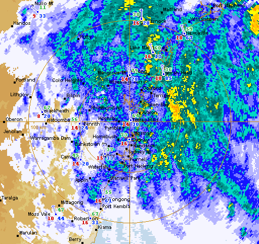
Today, however has more than doubled that figure. Rain in the form of showers arrived a bit after 5:30am this morning, initially moving in a southwesterly direction, and it has been almost unrelenting since then as the system developed into a larger, more dense area of rain. Sydney Airport has seen 73.0mm. This is easily the highest daily total of the year so far, surpassing January 27's 35.0mm. It also the highest total in six months; the previous higher total being 86.0mm on October 14 last year.
 |
| Sydney is somewhere in there! The Terrey Hills 128 km rain radar image at 6:30pm AEST on April 20 Source: Bureau of Meteorology (screenshot unedited from original image) |
 |
| Not much better. The Terrey Hills radar at 10pm Source: Bureau of Meteorology (screenshot unedited from original image) |
Wind gusts reached 70km/h yesterday at Sydney Airport, the strongest in just over four weeks. Wind speeds were around 55km/h until the late morning. By late afternoon they had increased above 70km/h. The strongest gust of today was 91km/h, not too long before midnight. That was surpassed at 12:05am on April 21 with a recording of 93km/h.
It wasn't only strong winds and rain that were felt in Sydney. Temperatures were also down. It reached a top of only 17.2C at the Airport. Coincidentally, this is the coldest maximum since October 15. Today also saw the coldest maximum for an April day at the Airport since 2009. Of the years since 2009, this is also the earliest date for such a low maximum. Maximums this low aren't typically seen for another couple of weeks. The daily minimum was the lowest seen since early November too. It dropped to 13.9C.
Sydney is in store for more of the same during the early hours of April 21 and rain and strong winds could continue until later in the day. More information to come...
No comments:
Post a Comment