Friday, 29 May 2015

Jyväskylä on the brink of summer, dry week in Sydney

The gradual arrival of summer in Jyväskylä this year has received a boost during this week. While that somewhat magical mark of 20C hasn't been surpassed yet, Monday through to Friday have seen maximums above 15C. This is the first string of five days above 15C since the middle of September last year.

The 20C barrier will surely be broken next week. Forecasts show Wednesday June 3 to be the first day. It has a current predicted maximum of 24C. The days following that are also predicted to be around 20C. With May ending on Sunday though, 2015 will be the only year since 2009 for Jyväskylä to not see a day in May above 20C.

One milestone for the year was surpassed on Wednesday May 27. The minimum at Tikkakoski held in double figures, right on 10.0C, for the first time since September 5. Compared to years since 2009, May 27 is the equal third latest. 2011 and 2012 didn't see a minimum at 10C or above until June 1 and 10, respectively. 2010, on the other hand saw the first occurrence on May 14.

Despite May 27's minimum at 10C, other minimums this week have been much lower at Jyväskylä Airport than predictions given by the Finnish Meteorological Institute last week. As a result, the overall average minimum for the month will be more than 1C lower than what had been predicted in my mid-month May progress post from May 19.

The sky over Jyväskylä on the morning of May 28

Another period of dry weather set in in Sydney this week. A run of five days of precipitation at Sydney Airport ended last Sunday and 0.2mm of rain this morning just before 8am is the only recording since then. Temperatures have also been fairly warm for this time of the year. Only Tuesday this week didn't exceed 20C. The long term average daily maximum for late May is around 19C.

The next few days will be more wintry though. May 31 through to June 5 currently don't have any predicted maximums higher than 18C and Tuesday June 2 could see morning temperatures dip to a chilly 6C. The minimum of 7.3C from May 14, one of only five minimums below 10C, remains the lowest so far this year.

Friday, 22 May 2015

Rain returns to Sydney, warmer in Jyväskylä

Rain returned to Sydney today. After a few weeks without a daily total greater than 2.2mm, the Airport picked up 19.2mm today, with most of it falling in the morning between 5am and 11am. It was the highest daily total since 27.2mm was recorded on May 2.

Very strong, gale force winds also struck the city. Southerly gusts over 70km/h were recorded from the mid morning up until the late afternoon. The strongest of 87km/h came at 12:26pm and was the strongest since the winds of the April 20-22 storm. It was also far stronger than any other gust seen in the Mays of 2013 and 2014. The previous strongest May gust since 2013 was 69km/h, recorded on the 13th of this month, only a week and a bit ago.

To round off a rather miserable day in the coastal city, temperatures were also down on previous days. It only reached 17.4C around 12:30pm at the Airport, putting it equal with May 13 as the coldest maximum of the month and the fourth lowest maximum for the year. May 20, however, saw only the second day of the month to break the 25C barrier.

The colour of green becoming more apparent at Jyväskylä's Rautpohja lake on May 21
In Jyväskylä, today has seen the third consecutive maximum above 15C for only the second time this year. After recordings of 15.7C and 15.5C on May 20 and 21, it came close to 18C today. May 6 is the only other day so far this year to go higher than 18C.

Showers drifted through Central Finland yesterday afternoon. Jyväskylä's city centre saw some rain fall around 6:30pm, but Tikkakoski didn't see any recordings. In the past month there have been only two blocks of two consecutive rain free days. May 20 and 21 was one of them along with the 4th and 5th of this month.

Temperatures will drop again tomorrow though. FMI forecasts a top of only 10C for Jyväskylä. The next 10 days still don't show any sign of breaking 20C either.

Tuesday, 19 May 2015

Contrasting averages for both cities so far this May

The first 19 days of May in 2015 have led to some contrasting averages for both Sydney and Jyväskylä compared to recent years. The two standout figures of the four are the average minimum at Sydney Airport, which has been well above figures since 2009, and the average maximum for Jyväskylä, which is on its way to the coolest recording of the past seven years.

Progressive average minimum for May at Sydney Airport for the period 2009-2015 plus the long term average

The progression of the average minimum has been unusual this year and, not surprisingly, it's above the long term average. May 2 and 3 saw the two highest minimums for May at the Airport since at least 2009. Even though May 14's 7.3C minimum was the lowest since 2011, the warm minimums have propped up the average. If those two recordings more normal, the average for 2015 would currently be sitting closer to that of 2013 and 2014. Forecasts show the average continuing to hover around 13C at least for the next week.

Progressive average maximum for May at Sydney Airport for the period 2009-2015 plus the long term average

The average maximum at Sydney Airport so far this month has been closer to normal. This is despite May 5 recording the seventh highest May temperature on record at the Airport. The 28.6C maximum was the highest May temperature since 2007. Other than 2007, only Mays in 1942, 1957 and 1994 recorded a higher maximum. It is actually the only maximum above 25C in the month so far though. The final average for the month will likely sit among the majority of recent years between 20C and 21C.

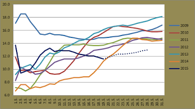
Progressive average maximum for May at Jyväskylä Airport for the period 2009-2015

Jyväskylä's relatively cool start to May has led to the average maximum dipping below all other years bar 2014 up until today. 2014's cold start made way for almost record highs on this exact day one year ago though and the dramatic increase in the average from the 16th is evident in the graph above. Unlike 2014, however, it doesn't look like Jyväskylä will be seeing any maximums at those levels. The forecast up until May 28 doesn't even show one day above 20C. If the predictions are correct, May 2015 will definitely have the lowest average since 2009.

Progressive average minimum for May at Jyväskylä Airport for the period 2009-2015

While the average maximum is on its way to the lowest of the past few years, the average minimum is looking likely to record the highest figure since 2009. Only two minimums have been below zero at this point of the month. This is lower than the whole of any May between 2009 and 2014. The 10 day forecast currently doesn't show any minimums below 5C either. Up until today, there have also been seven figures above 5C. 2010 had seen the same amount, but other years had a lower number of occurrences.

Monday, 18 May 2015

Summer still on hold in Jyväskylä, signs of winter in Sydney

Summer 2015 is taking its time to arrive in Finland. It was assured today that 2015 would record the latest date for the first temperature above 20C in Jyväskylä in the years since 2009. In the six years from 2009 to 2014, the earliest day of the year to record the first maximum above 20C has ranged from April 26 in 2011 to May 18 last year. The highest temperature so far in 2015 at Jyväskylä Airport is 18.1C, recorded on the 6th of this month.

The May 6 maximum is one of only three days above 15C so far at Tikkakoski this year. Going up to May 18, this is the lowest number of days for all years since 2009. 2009 and 2013 had seen 11 days by this point, while the average across the previous years is a bit over eight. May 16's maximum of 9.8C is a long way off the maximum of 28.3C on the same day in 2010 as well. 

The cooler temperatures are likely to continue too. The current 10 day forecast still doesn't show any days above 20C. Between 2009 and 2014, the highest respective May temperatures have ranged from 22.4C in 2011 to 29.3C last year.

In addition to the cooler weather, rain has also been around. Since May 6, only the 16th hasn't seen any precipitation recorded at Tikkakoski. The highest daily rainfall of the year was set anew on Wednesday May 13 when 22.7mm was recorded. This almost doubled the previous highest total of 11.6mm from the second day of the year. There were only four days in 2014 with a total over 22.7mm.

In Sydney, the past week has seen some early chills of winter. The past six days have failed to climb above 20C, equalling the longest run below the mark since a string of 13 days last August. The lower temperatures aren't really that unusual for this time of the year, but it's quite different from last May when some exceptionally warm weather arrived in Sydney.

Minimums for the past couple of days have also been fairly normal, in the low teens, but there was definitely a wintery feel about the afternoon of Wednesday May 13. Temperatures reached 17.4C at the Airport just after midday, but a southerly change dropped the mercury closer to 10C already before 4pm. A few showers made their way across the city as well, dropping 2.2mm at the Airport. Snow was even sighted near Goulburn, 170km southwest of Sydney. 

The late evening of the 13th saw temperatures drop below 10C for the first time this year and for the first time since mid-October last year. The following morning of May 14 recorded a minimum of 7.3C, the coldest May minimum at Sydney Airport since 2011.

After seeing 44.4mm fall on May 1 and 2, the following 16 days at the Airport have seen only 3.8mm more added to the monthly total. May 4 to 12 saw no rain and this is the second longest dry streak so far this year. 

Saturday, 9 May 2015

April 2015 Review - Sydney

April in 2015 was a month filled with exceptional weather observations in Sydney. Sydney Airport saw many extremes throughout, some of which were the highest and lowest respective figures for several years, but the key part of the month came on April 20, 21 and 22 when an extensive and damaging storm system struck the New South Wales coast. In the end, the average minimum held above the long term figure at the Airport, the average maximum was below, and the monthly rainfall total was three times the average and the highest for a month since May 2003.

The graph below shows the averages for April during the past seven years. The long term figure is also shown.

April averages at Sydney Airport for the period 2009-2015 plus the long term average

The Bureau of Meteorology recorded slightly higher averages of 15.3C and 22.6C. The failure of the average maximum to exceed the long term figure is the first occurrence since August last year. It also became the 39th month since the start of 2000 to record a below average maximum. That means almost 80% of the months since 2000 have been above the long term figure.

While the average maximum recorded a below average figure, the average minimum was once again above the long term recording. Since the start of 2009, there have been only two months, May and December in 2011, which recorded a below average average minimum.

The hottest day of the month was April 16 when it reached 32.6C at the Airport. That figure was the highest April temperature since 2006. April 2's 31.0C was also higher than any other April figure since 2006. The lateness of the 32.6C recording on the 16th was unusual too. Only once before in Sydney Airport's 77 years of April recordings has a temperature exceeding 32.6C been recorded later, but before winter, than April 16. That occurred in 2005 when 33.9C was seen on April 18.

The warmest minimum for the month was 20.1C on April 18. This was the highest figure in the years since 2009. The Bureau's differing methodology for recording temperatures limits my search for this figure, but they recorded April's highest minimum at 20.2C for the 18th and, according to their records, it is the highest since a 20.3C recording in 2009.

The two coldest days were part of the April 20-22 storm. It topped 17.2C and 17.1C on the 20th and 21st. These were also the lowest since 2009. The overall lowest temperature came on April 28. It fell to 10.6C then. It was also 10.7C on the 29th. These are the lowest April temperatures since 2012. Only three daily minimums have been below 10C in Aprils since 2009.

The April 20-22 storm accounted not only for the coldest days of the month, but also the wettest and windiest. Rainfall would have been extraordinary for any month of the year in Sydney. A total of 338.4mm fell across the calendar month of April, while the Bureau's total of 349.0mm was more than triple the long term average of 109.3mm.

Daily minimums and maximums against rainfall at Sydney Airport for April 2015

April 2015 was the second wettest April at Sydney Airport in its 86 year history of rainfall recordings and the wettest month overall since May 2003. For the month of April, only 1988's remarkable 476.2mm is higher, while only six Aprils since 1930 have exceeded 300mm. At Observatory Hill the monthly total was 366.8mm, making it the seventh wettest April there since records began in 1859 and the wettest since 1989.

At the Airport there were 21 days of rain. The longest streak was eight, from April 16 to 23, while the longest dry streak was only four, from the 12th to 15th. The wettest day was April 22 when 111.2mm fell. April 20 and 21 saw 73.0mm and 63.6mm, bringing the three day total to 247.8mm. As mentioned in a previous post, the Bureau's three day total of 241.8mm was the highest three day total in over 23 years.

Wind gusts were also quite remarkable. The maximum gusts from the storm didn't exceed those seen last October, which were over 100km/h, but April 20, 21 and 22 recorded maximum gusts of 96km/h, 91km/h and 89km/h. Direction of these gusts were south-southeasterly (96km/h) and the remaining two were southerlies. The average of maximum gusts for the month was much higher than the previous two Aprils. April 2015 saw an average of 51.9km/h, compared to 40.5km/h in 2013 and 43.3km/h in 2014.

At the other end of the spectrum, the calmest maximum gust was a case of the calm before the storm. The 26km/h east-northeasterly gust came on the 17th.

Monday, 4 May 2015

April 2015 Review - Jyväskylä

Finland saw above average monthly temperatures again in April 2015. The differences above the average weren't quite as great as those seen in February and March though. The greatest differences, 2.5C to 3.0C above average, were seen in the far north, but almost the whole southern half of the country, including Jyväskylä, saw a maximum difference up to only 1.5C. Rainfall distribution varied quite a lot across Finland during the month, but Jyväskylä recorded an almost average total.

According to the Finnish Meteorological Institute, the average temperature in Jyväskylä was 3.4C. My figures resulted in an average of 3.7C. This is against last year's 3.7C (3.3C), and the long term figure of 2.2C.

The average minimums and maximums for the past seven Aprils can be seen below.

April averages at Jyväskylä Airport for the period 2009-2015

The average minimum of -0.3C for this year is the highest of the past seven Aprils. The average maximum is also quite high in comparison to recent years, although still 2C and 1.5C lower than the respective years of 2011 and 2014. FMI records show that 14 of the past 17 Aprils in Jyväskylä have been above the 1981-2010 average.

Jyväskylä's extremes for the month ranged from -5.3C on April 6 to 14.9C on the 12th. The -5.3C figure was the second highest such figure in the years since 2009, colder only to the -5.1C seen in 2010. Aprils from 2011 to 2014 all saw a minimum below -10C. A maximum of 14.9C is right in the middle of figures from 2009 onwards. 2013 saw the lowest figure with 12.6C.

Both April 2 and 3 saw the coldest maximum of the month. It only topped 2.0C on each day. This was the equal second highest respective figure, while the highest minimum was the second lowest. April 8 saw a lowest temperature of 3.1C. Only April 2010's figure of 2.8C was lower. 2009, 2011, 2012 and 2014 all saw a figure above 4C.

The national extremes for April were, strangely enough, recorded on the same day. April 12 saw very warm temperatures in the southern half of the country. It reached 17.1C in the Southern Ostrobothnian town of Kauhava. In the Lapland town of Kittilä, however, it dipped to -15.5C.

Minimums during the month remained fairly stable and maximums only climbed slightly, as seen in the graph below. Another observation from April 2015 was the lack of cold nights, but, as mentioned above, warm nights were also uncommon. April 2015 also saw a lower difference between the average minimum and maximum than any other year since 2009.

Daily minimums and maximums against rainfall at Jyväskylä Airport for April 2015

Rainfall was distributed unevenly across the country. The south east saw the highest totals. Some locations there recorded over double the average April rainfall, but southern parts of the Finnish west coast, as well as from just south of Oulu to the far north, saw below average totals.

A total of 13 days of precipitation led to a total of 33.0mm for Jyväskylä. FMI recorded 34mm. Both are very close to the 1981-2010 figure of 35mm. April in 2014 saw only 21mm. April 23 was the wettest day for Jyväskylä. A total of 8.7mm fell at Tikkakoski. The 23rd was one of three days that saw a daily total above 5mm; the 26th and 29th being the other two. There were two three day streaks of rain; April 2 to 4 and 12 to 14. The longest dry streak was seven days from the 5th to 11th.

There was no snow left at Tikkakoski by April 15. The bare winter of 2014 meant there was no snow by the same date as well, but the average depth between 1981 and 2010 at April 15 was 19cm.

A strong low pressure and storm system moved into Finland on April 29. Only 8.0mm was recorded at Jyväskylä, some of which was wet snow, but other locations saw much higher totals. Puolanka, north of Kajaani in the Kainuu region of Finland, had 91cm of snow by the month's end. Some locations in that part of Finland saw up to 20cm of fresh snow as a result of the April 29 storm. FMI reported such high levels of snowfall as very unusual for this time of the year.

Wet run for east coast ends, up and down in Jyväskylä

Another intense low pressure system and associated trough affected Australia's east coast at the end of last week. The worst hit areas this time though were on the North Coast of New South Wales and in South East Queensland. On Friday May 1 Brisbane saw 200.2mm recorded, 100mm of which fell between 2:30pm and 5:30pm. Beerburrum, north of Brisbane saw 268.0mm. Flooding was reported across the city and led to road closures and cancellations for public transport. Rugby league's Anzac Test was also postponed to Sunday due to flooding at Brisbane's Suncorp Stadium.

There were also strong winds along the coast. Cape Moreton, on Moreton Island, saw a top gust of 109km/h. It was the strongest gust recorded there since at least the start of April last year. Inland locations were calmer.

Wet weather continued in Sydney at the end of last week as well. Easterly winds associated with the new low brought showers across Sydney between April 29 and May 2. The final two days of April saw 14.4mm and 16.6mm recorded at the Airport, while the opening two days of May saw 17.2mm and 27.2mm, bringing the four day total to 75.4mm.

With not one of the final five days of April exceeding 19.5C,  the average maximum for the month at Sydney Airport dropped from 23.3C to 22.5C. April 28 and 29 also saw lows of 10.6C and 10.7C, the former of which was the coldest April temperature at the Airport since 2012.

The start of May has already seen an unusual recording at the Airport. The minimum from May 3 of 19.0C is among the highest on record for the month of May. The Bureau of Meteorology's methods led to a recording of 18.6C for the 3rd, although this measurement was seen already before midnight on May 2. According to Bureau records (and methods), the all time record for the highest May minimum at Sydney Airport is 19.1C, recorded way back in 1942. My records dating from 2009 show a highest May minimum of 16.3C, recorded last year. In contrast, 2013 last saw a minimum above 19C before the winter on March 28.

The past six and a half weeks, or 46 days, at Sydney Airport have seen only 14 days without rain and the longest dry streak has extended for only four days. It seems that drier weather has finally arrived though. Melbourne will potentially see some wild weather tomorrow, but a series of high pressure systems will move into position over Australia in the coming days, bringing dry weather to the whole country, bar the south east, for at least the time being. The current forecast for Sydney shows only sun for the coming week.

In Jyväskylä temperatures have continued their recent up and down run. After late season snow on April 29, May Day celebrations in Jyväskylä were helped as the second highest temperature of the year was recorded, when it climbed to 13.7C at Jyväskylä Airport. Saturday May 2, however, saw the lowest daily maximum for a day in May in the years since 2009 when it reached only 5.1C. May 3 then climbed back above 10C.

Snow falling in Jyväskylä on April 29

A pattern in the rainfall in Jyväskylä can be seen in the recent week and a half. In the 12 days from April 23, there have been four three day periods in which the first two saw rain while the third remained dry. For example, April 23 and 24 saw 8.7mm and 1.6mm, but the 25th was dry. Then April 26 and 27 recorded 5.4mm and 0.3mm, before no rain fell on the 28th.

Isolated showers rolled through Central Finland on May 3 and 4.
This is Tuomiojärvi with Laajavuori in the background during the afternoon of May 3

The coming week will see a continual rise in temperatures. The first day above 15C at Tikkakoski for the year is still in waiting. In the past six years the first date for such a temperature has ranged between April 21 in 2014 to May 12 in 2010. The current forecast indicates that Wednesday May 6 will be the first day in 2015. The first day of the year above 20C doesn't appear in the current forecast yet. 2009 and 2011 had already seen their first days above 20C by this time.