So, what has been happening with the weather in Sydney and Jyväskylä during the past six weeks? Perhaps surprisingly, the period has only seen a slight shift in weather conditions as the new seasons of winter and summer draw closer.
The change between the middle of February and now can be noticed in different ways between the cities. In Sydney, it's the figures themselves that are the difference. Daily minimums and maximums are slowing dropping, with minimums dropping at a slightly quicker rate, but in Jyväskylä, it's maybe more the melting of snow and longer days, rather than the figures themselves, which, other than a week long period earlier this month, haven't been especially different.
Sydney is first up. In order to catch up with what has been happening, let's have a look at the year so far...
 |
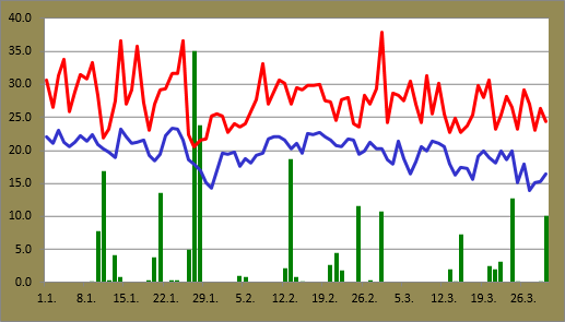
| Daily minimums and maximums against rainfall at Sydney Airport for 2015 up until March 30 |
Since the middle of February daily maximums have comfortably held around 25C and above. A downward trend in the figures is still visible though.
The tall spike is from March 1 when the temperature reached 37.9C at the Airport. This was the hottest temperature at the Airport since the 38.0C reading from November 14 last year. In terms of March extremes, this was the highest March temperature since the 40.3C recording on March 9 in 2004. It was also the seventh highest March reading at the Airport on record. 1983 saw the record of 41.2C.
March 13 saw the lowest maximum during the last six weeks with a top of 22.7C.
The decrease in minimums is a lot clearer in the graph. Since March 12, only one minimum hit the 20C mark. The average minimum for March this year is actually on track to be one of the lowest in recent years. March 27 saw it dipped to 14.0C, the lowest of the year so far, and the second time below 15C. 2010, 2011 and 2014 didn't see a minimum below 15C until April.
 |
| Blue skies over Sydney Harbour on March 7 |
Rainfall totals weren't especially high during the month and a half period. Since 18.6mm fell on February 13, the highest daily total was 12.8mm a week ago on March 24. Including that and today's 10.0mm, there were four days with figures at or above 10mm. Comparing to the same point last year, the cumulative total so far this year is slightly lower; 208.0mm against 219.0mm.
March 1 was probably the highlight day since the middle of February. In addition to the heat, the end of the day saw a very gusty southerly change and storm activity around the Sydney region. A total of 10.8mm was recorded at the Airport along with a strongest gust of 96km/h. This is the third highest strongest daily gust since the start of 2013.
 |
| Daily minimums and maximums against rainfall at Jyväskylä Airport for 2015 up until March 29 |
Most of the period while I was absent from Finland saw very little change in Jyväskylä. The 16 days from February 20 through to March 7 saw the temperature hover between a low of -1.8C and a high of 3.6C, a difference of only 5.4C.
Luckily for me, my return to the northern hemisphere on March 13 was followed by some of the nicest weather seen in Jyväskylä since last autumn. Clear skies, cold nights and warm days dominated until the 20th. Both March 17 and 18 maxed out at 11.2C. This was easily the earliest time in the year for such a temperature compared to other years since 2009. Other than last year, that kind of maximum wasn't seen until late April.
 |
| Ice of Kallavesi, north of Kuopio, on March 26 |
Daily maximums dipped quickly back closer to zero on the 20th. March 21's maximum of -3.1C was the coldest in over a month. Since my last post on February 17, there have only been three daily maximums below 0C. That's quite a remarkable number comparing to the six previous years. The same 40 day period in 2013 saw 29 days entirely below zero. 2009, 2010, 2011 and 2012 saw 25, 23, 20 and 14 days respectively below the mark. Even last year's warm late winter period saw eight such days.
March 22 saw the lowest temperature at Jyväskylä Airport since February 16 when it dropped to -14.5C, while the 28th's 0.5C reading was the first minimum above zero in almost three weeks.
Other than the exceptionally warm period in the middle of this month, which saw 10 consecutive rain free days, precipitation so far this year has been fairly consistent. As mentioned during the winter, snow depths have been much higher than last year, and while warmer temperatures have melted most of the snow on paths and roads, there is still some snow on grassed and in wooded areas. Snowfall in the past couple of days has also added to the icy remnants of winter's earlier precipitation.
 |
| Rain helped to melt the snow further on March 29 but it created muddy puddles in the process |
In terms of coming weather, the approaching cooler period for Sydney is becoming more apparent as we head into April as lower minimums and maximums continue. Since 2009, there were only three days in total that managed to hit 30C from March 30 up until the arrival of spring.
In Jyväskylä it appears that spring is on hold, with snow and wet snow, as well as temperatures only a couple of degrees above zero, continuing for the time being. These conditions actually aren't unusual for this of the year, but recent bursts of warmer temperatures have maybe given some false hope for a quick arrival of spring.
No comments:
Post a Comment