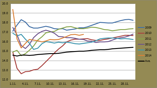
The recent figures aren't really at either the extreme end of hot or cold, but they are above average for this time of year. For some comparison though, November 27 in 2010 recorded daily figures ranging from -15.8C to -10.0C, while November 25 in 2011 recorded daily numbers of -1.9C and 7.0C.
Another interesting observation from the past couple of weeks is that since November 12, not one day has seen a difference between the minimum and maximum exceed 5C. November 20's 4.4C difference is the highest in the two week period, and excluding that figure the average difference is only 1.8C. This has meant very consistent temperatures during each day with very little fluctuation. During the whole period the lowest temperature recorded has been -5.9C, while the highest is yesterday's maximum of 2.8C, meaning a difference of only 8.7C between November 13 and 27.
The warmer temperatures this week have caused pretty much all of the snow that was on the ground to disappear. Only a few isolated clumps remain around the city. There has been a bit of drizzle around this week as well. Tuesday, yesterday and today have seen respective figures of 1.1mm, 0.6mm and 1.0mm.
 |
| Sun? Well almost. November 27 started off dry but drizzle arrived later in the afternoon. |
Sydney Airport saw its coolest day of the month today. It reached only 21.1C just before 2pm this afternoon, just below November 6's maximum of 21.2C. It also ended an eight day streak above 25C. It does mean, however, that Sydney Airport has currently not recorded a daily maximum below 20C this November.
Only twice before in the station's 76 year history has this happened for the month of November. 1997 was the most recent occurrence when the lowest daily maximum was 20.2C. 1972 was the other with a figure of 20.0C. With only a few days of the month remaining and forecasts showing daily highs at 24C tomorrow and 27C and 30C for the weekend, this will be a new record for Sydney Airport.
This current run of maximums above 20C has also extended to 37 days. The highest such streak in the second half of a year since 2009 is 50 days. November 7 to December 26 of 2010 all recorded maximums above 20C. 2013 had the second highest number with 43, while 2009 had the lowest with 25. Based on current forecasts, 2014 will at least surpass 2013's figure.
One thing that I missed last week was that November 20 was the first day with a minimum above 20C since the last summer season. March 26 was the previous occurrence. November 20 is actually the equal latest date for such a recording in the years since 2009. 2009 also recorded its first minimum above 20C on November 20. Other years recorded their first occurrence in early November, although 2013 saw it already on October 23.
Lastly, Brisbane was hit by a very powerful storm this afternoon. Very strong wind gusts, large hail and heavy rain struck the city area. There were reports of it being the strongest storm in more than a decade. The Brisbane weather station recorded almost 40mm in only 30 minutes from 4:30pm onwards. Images can be found here while some video footage can be seen below.