 |
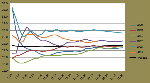
| Progressive average minimum for October at Jyväskylä Airport for the period 2009-2014 |
The average minimum has spent most of the month as the second lowest. A cold start to the month, which included four daily minimums below -3C in the first six days, has contributed greatly to the low number. October 9, 10 and 11, however, pushed the average up as each day recorded a minimum above 6C. Even with the two coldest October temperatures since at least 2009 being measured this week, the return of warmer temperatures over the weekend and early next week should push the 2014 average minimum somewhere close to that of 2010.
 |
| Progressive average maximum for October at Jyväskylä Airport for the period 2009-2014 |
As is typically seen in the few months following July, the average maximum for Jyväskylä has dropped steadily since the start of the month. Once again figures are quite similar to those seen in 2010. This week has seen two of the coldest October days since at least 2009 and the effect of that can be seen by the recent sharp dip of the orange line in the graph. As with the average minimum, forecasts suggest the average maximum will stabilise and end up close to the average from 2010.
October 2014 in Sydney has seen its ups and down, but so far it has been a rather warm month. Both the average minimum and maximum sit comfortably above the long term average.
 |
| Progressive average minimum for October at Sydney Airport for the period 2009-2014 plus the long term average |
The average minimum for October 2014 spent a few days as the highest, but the 14th, 15th and 16th quickly dropped it to more than a degree lower than 2010's figure. A recent recovery and warm forecasts suggest 2014's average minimum could surpass 2010. If it goes higher than 14.7C, it will be the warmest since 2007.
 |
| Progressive average maximum for October at Sydney Airport for the period 2009-2014 plus the long term average |
Last October in Sydney recorded the second warmest average maximum on record. October 2014 started in similar fashion and looked to challenge last year's result, but the few days around October 15, which itself recorded the lowest daily maximum since 2008, has dropped the figure closer to that of 2012. Current forecasts suggest that 2014 will record the second highest average maximum since 2007.
No comments:
Post a Comment