The last couple of days in Finland have been unusually warm. As mentioned in my last post, the low pressure system in the Norwegian Sea has been pushing warm and moist air across the Nordic region, driving up temperatures and bringing areas of rain.
Yesterday saw Finland broke its 'end of October' heat record. As this Yle article explains, a measurement of 14.2C was recorded in Kokemäki, a town slightly inland and south east of the west coast town of Pori. The previous record was from October 26 1975; a 14.1C maximum recorded in Jomala on the Åland Islands.
Jyväskylä has also seen very warm temperatures this week. After climbing above 10C on Monday, they jumped 2C higher to 12.0C on the 28th. Temperatures still hovered just under 12C in the early hours of today, giving a top of 11.8C.
Of the past six years, this is the latest time in the year for such warm weather. In the five years between 2009 and 2013, the dates for the last time a maximum at 12C or above was recorded range from September 27 (2009) to October 9 (2013). For further comparison, October 29 in 2009 and 2012 recorded daily maximums of 0.0C and 0.3C respectively.
The warmth on Tuesday wasn't enough to topple October 9's 12.9C maximum as the highest recorded this month. It was, however, the sixth day above 10C. Today made it seven above the mark, the equal second highest number of such a recording in the past six Octobers.
Jyväskylä saw its fifth straight day of rain today as well. Since Saturday October 25 and up until 10pm tonight, a total of 24.8mm has been recorded at Tikkakoski. There were 19 consecutive hours of precipitation recorded yesterday, but the daily total only reached 4.0mm. Persistent drizzle meant that not one hourly total in those 19 hours exceeded 0.5mm. Like Monday, skies cleared in the evening, and bright sun was even seen this morning before more rain arrived just before 2pm.
Wednesday, 29 October 2014
Monday, 27 October 2014
Climbing temperatures in both cities
Signs of summer have returned to Sydney again over the past few days. The past five days have all recorded high levels of sunshine and a maximum above 25C. Thursday and Friday rose to 27.6C and 28.1C respectively, before temperatures dropped slightly to 25.4C on Saturday. Sunday saw the warmest day in three weeks. It reached 30.9C. Today was also hot. Very strong northwesterly winds took temperatures up to 33.2C at Sydney Airport.
The strong winds reached gale force this afternoon. A steady coastal breeze turned to a northwesterly around 2:45pm at the Airport and average wind speeds were quickly above 50km/h. A peak gust of 83km/h was recorded at 3:03pm. So far this year there have been 11 days with a maximum gust at or above 80km/h at the Airport. Today's gust ranked as the equal sixth strongest of those. 2013 had recorded 11 such days by this time of the year also. Mount Boyce, in the Blue Mountains, had the strongest recorded gust today within the Bureau's defined area of Sydney. A westerly at 120km/h was measured there at 1:52pm.
Minimums have been more like those seen in summer too. It hasn't been below 15C since last Wednesday with morning temperatures hovering around 18C. This morning didn't go lower than 19.2C. If not for a southerly change late this evening, this would have been the first minimum above 19C since April 11, more than six months ago. Of the past six years, only 2013 had seen a minimum that warm by October 27, following winter.
A few showers were seen around Sydney on Friday and over the weekend. The Airport, however, only recorded a measly 1.0mm over the three days. A small but dangerous storm struck Sydney's west on Thursday afternoon. A total of 16.2mm fell in a very short space of time at Penrith. However, no other Sydney weather stations recorded significant falls.
Despite it being the opposite season, temperatures in Jyväskylä have also been steadily climbing. The sun hasn't made an appearance though. Since last Thursday's very cold October minimum of -13.6C, it has continuously climbed more than 20C to just over 10C today. A very large low pressure system, remnants of the Atlantic storm Hurricane Gonzalo that struck the UK last week, currently sits in the Norwegian Sea. It is generating strong winds as well as sending warm and moist air across the Nordic region.
I said last week that, despite the forecast, there was a decent chance that there wouldn't be any more days in excess of 10C for the rest of the year in Jyväskylä, but extended forecasts at the time have stayed true to their predictions. Today's maximum is the warmest seen in more than two weeks, and well above the daily maximums of -3.4C and -3.0C from October 22 and 23.
In addition to the warmer temperatures, incessant light rain and showers have affected Jyväskylä since early Saturday morning. A daily total of 6.1mm was recorded on the 25th. Yesterday followed that up with 3.4mm, pushing the monthly total above the long term average in the process. Today has also seen falls. As the sky started to clear around 4pm, 6.0mm had been recorded at Tikkakoski, taking the total to 78.4mm with four days of the month remaining.
The strong winds reached gale force this afternoon. A steady coastal breeze turned to a northwesterly around 2:45pm at the Airport and average wind speeds were quickly above 50km/h. A peak gust of 83km/h was recorded at 3:03pm. So far this year there have been 11 days with a maximum gust at or above 80km/h at the Airport. Today's gust ranked as the equal sixth strongest of those. 2013 had recorded 11 such days by this time of the year also. Mount Boyce, in the Blue Mountains, had the strongest recorded gust today within the Bureau's defined area of Sydney. A westerly at 120km/h was measured there at 1:52pm.
Minimums have been more like those seen in summer too. It hasn't been below 15C since last Wednesday with morning temperatures hovering around 18C. This morning didn't go lower than 19.2C. If not for a southerly change late this evening, this would have been the first minimum above 19C since April 11, more than six months ago. Of the past six years, only 2013 had seen a minimum that warm by October 27, following winter.
A few showers were seen around Sydney on Friday and over the weekend. The Airport, however, only recorded a measly 1.0mm over the three days. A small but dangerous storm struck Sydney's west on Thursday afternoon. A total of 16.2mm fell in a very short space of time at Penrith. However, no other Sydney weather stations recorded significant falls.
Despite it being the opposite season, temperatures in Jyväskylä have also been steadily climbing. The sun hasn't made an appearance though. Since last Thursday's very cold October minimum of -13.6C, it has continuously climbed more than 20C to just over 10C today. A very large low pressure system, remnants of the Atlantic storm Hurricane Gonzalo that struck the UK last week, currently sits in the Norwegian Sea. It is generating strong winds as well as sending warm and moist air across the Nordic region.
I said last week that, despite the forecast, there was a decent chance that there wouldn't be any more days in excess of 10C for the rest of the year in Jyväskylä, but extended forecasts at the time have stayed true to their predictions. Today's maximum is the warmest seen in more than two weeks, and well above the daily maximums of -3.4C and -3.0C from October 22 and 23.
 |
| Skies starting to clear just after 4pm on October 27 |
 |
| First break in the clouds seen in Jyväskylä for several days |
In addition to the warmer temperatures, incessant light rain and showers have affected Jyväskylä since early Saturday morning. A daily total of 6.1mm was recorded on the 25th. Yesterday followed that up with 3.4mm, pushing the monthly total above the long term average in the process. Today has also seen falls. As the sky started to clear around 4pm, 6.0mm had been recorded at Tikkakoski, taking the total to 78.4mm with four days of the month remaining.
Friday, 24 October 2014
October progress with a week remaining
Compared to some recent editions, Jyväskylä has seen a pretty cold October in 2014. While figures haven't been as low as those seen in 2009, they are currently lower than the four years between 2010 and 2013.
The average minimum has spent most of the month as the second lowest. A cold start to the month, which included four daily minimums below -3C in the first six days, has contributed greatly to the low number. October 9, 10 and 11, however, pushed the average up as each day recorded a minimum above 6C. Even with the two coldest October temperatures since at least 2009 being measured this week, the return of warmer temperatures over the weekend and early next week should push the 2014 average minimum somewhere close to that of 2010.
As is typically seen in the few months following July, the average maximum for Jyväskylä has dropped steadily since the start of the month. Once again figures are quite similar to those seen in 2010. This week has seen two of the coldest October days since at least 2009 and the effect of that can be seen by the recent sharp dip of the orange line in the graph. As with the average minimum, forecasts suggest the average maximum will stabilise and end up close to the average from 2010.
October 2014 in Sydney has seen its ups and down, but so far it has been a rather warm month. Both the average minimum and maximum sit comfortably above the long term average.
The average minimum for October 2014 spent a few days as the highest, but the 14th, 15th and 16th quickly dropped it to more than a degree lower than 2010's figure. A recent recovery and warm forecasts suggest 2014's average minimum could surpass 2010. If it goes higher than 14.7C, it will be the warmest since 2007.
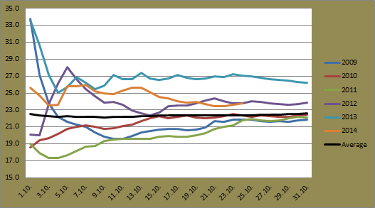
Last October in Sydney recorded the second warmest average maximum on record. October 2014 started in similar fashion and looked to challenge last year's result, but the few days around October 15, which itself recorded the lowest daily maximum since 2008, has dropped the figure closer to that of 2012. Current forecasts suggest that 2014 will record the second highest average maximum since 2007.
 |
| Progressive average minimum for October at Jyväskylä Airport for the period 2009-2014 |
The average minimum has spent most of the month as the second lowest. A cold start to the month, which included four daily minimums below -3C in the first six days, has contributed greatly to the low number. October 9, 10 and 11, however, pushed the average up as each day recorded a minimum above 6C. Even with the two coldest October temperatures since at least 2009 being measured this week, the return of warmer temperatures over the weekend and early next week should push the 2014 average minimum somewhere close to that of 2010.
 |
| Progressive average maximum for October at Jyväskylä Airport for the period 2009-2014 |
As is typically seen in the few months following July, the average maximum for Jyväskylä has dropped steadily since the start of the month. Once again figures are quite similar to those seen in 2010. This week has seen two of the coldest October days since at least 2009 and the effect of that can be seen by the recent sharp dip of the orange line in the graph. As with the average minimum, forecasts suggest the average maximum will stabilise and end up close to the average from 2010.
October 2014 in Sydney has seen its ups and down, but so far it has been a rather warm month. Both the average minimum and maximum sit comfortably above the long term average.
 |
| Progressive average minimum for October at Sydney Airport for the period 2009-2014 plus the long term average |
The average minimum for October 2014 spent a few days as the highest, but the 14th, 15th and 16th quickly dropped it to more than a degree lower than 2010's figure. A recent recovery and warm forecasts suggest 2014's average minimum could surpass 2010. If it goes higher than 14.7C, it will be the warmest since 2007.
 |
| Progressive average maximum for October at Sydney Airport for the period 2009-2014 plus the long term average |
Last October in Sydney recorded the second warmest average maximum on record. October 2014 started in similar fashion and looked to challenge last year's result, but the few days around October 15, which itself recorded the lowest daily maximum since 2008, has dropped the figure closer to that of 2012. Current forecasts suggest that 2014 will record the second highest average maximum since 2007.
Tuesday, 21 October 2014
Jyväskylä catch-up - Cold, a bit wet and first snow on the ground
There are very few leaves on trees around Jyväskylä right now as winter draws closer. Weather since October 10 has been rather cold. It has also been wet at times and mostly grey. Other than the 10.8C maximum on the 11th, the fourth day above 10C this month, temperatures have dropped to some of the lowest seen at this time of year since 2009. Only one day between October 12 and today has climbed above 5C.
As it stands, a figure of four days above 10C would be the second lowest number since 2009. October 2009 saw no days above 10C. 2013 saw 10. Forecasts for next week are fluctuating quite a bit at the moment, but it's likely that there will not be another day above 10C this year.
Cold temperatures have also been recorded during the night in the past week and a half. The current average minimum for the month sits above only 2009. October 17 had temperatures drop to -7.9C. The 18th went even further, dipping below -10C to -10.4C. This was the coldest October temperature seen since at least 2009 and it is by far the earliest date for the first recording below -10C, as shown in the image below. Today's sub-zero maximum of -0.5C is also the earliest date for a maximum below 0C.
The 10C plus temperature from October 11 was accompanied by rain also. Falls mostly in the morning accounted for 13.8mm. No rain was measured between the 13th and 18th, but Sunday October 19 saw a band of widespread rain move east across the country. Jyväskylä Airport managed to record its second highest daily figure seen this year with a total of 26.4mm. The highest daily total was recorded on May 26 when isolated storms dumped 28.1mm. The monthly total for October now stands at 62.9mm, just short of the 1981-2010 average of 66mm.
This morning saw snow on the ground in Jyväskylä centre for the first time this season. Light rain yesterday afternoon turned to snow flurries as the evening wore on. Snow was in isolated patches though and not visible on any roads or paths.
As it stands, a figure of four days above 10C would be the second lowest number since 2009. October 2009 saw no days above 10C. 2013 saw 10. Forecasts for next week are fluctuating quite a bit at the moment, but it's likely that there will not be another day above 10C this year.
Cold temperatures have also been recorded during the night in the past week and a half. The current average minimum for the month sits above only 2009. October 17 had temperatures drop to -7.9C. The 18th went even further, dipping below -10C to -10.4C. This was the coldest October temperature seen since at least 2009 and it is by far the earliest date for the first recording below -10C, as shown in the image below. Today's sub-zero maximum of -0.5C is also the earliest date for a maximum below 0C.
 |
| Dates for Jyväskylä's first minimum below -10C and maximum below 0C for the previous six winters |
The 10C plus temperature from October 11 was accompanied by rain also. Falls mostly in the morning accounted for 13.8mm. No rain was measured between the 13th and 18th, but Sunday October 19 saw a band of widespread rain move east across the country. Jyväskylä Airport managed to record its second highest daily figure seen this year with a total of 26.4mm. The highest daily total was recorded on May 26 when isolated storms dumped 28.1mm. The monthly total for October now stands at 62.9mm, just short of the 1981-2010 average of 66mm.
This morning saw snow on the ground in Jyväskylä centre for the first time this season. Light rain yesterday afternoon turned to snow flurries as the evening wore on. Snow was in isolated patches though and not visible on any roads or paths.
 |
| Snow on the ground in Jyväskylä during the afternoon of October 21 |
 |
| Barren and empty trees are visible throughout the city
The coming few days will see very cold October temperatures. It looks like it'll remain below 0C until Friday evening. A maximum of -2.0C from 2012 is the coldest such figure since 2009, but tomorrow or Thursday could beat that. Next week will see a return to warmer temperatures though as a low pressure system moves in, bringing rain along with it.
|
Monday, 20 October 2014
Sydney catch-up - Destructive storms, cooler temperatures
What a week to go on holiday. While I was enjoying the unusual autumn warmth of Slovenia, both Sydney and Jyväskylä saw some very interesting weather events last week. In order to get updated with what has happened since my last post on October 10, this is the first of two catch-up posts. So let's look at Sydney first...
The weekend of October 11 and 12 was somewhat uneventful. Both days saw warm maximums around 29C at the Airport and minimums hovered around 15C. Wind speeds picked up on Sunday with a maximum daily gust of 63km/h, the strongest in a week, but that was nothing compared with what was to come.
A severe weather warning was in place for most of New South Wales on Monday. It warned of an intense double low pressure system that included rain, strong winds and storm activity that was moving east across the state. Monday warmed up to 25.7C while northwesterly winds increased further as the front moved in.
Storm activity was building west of the city and it struck in the afternoon. Sydney's west bore the brunt of the storm, but the Airport saw 11.8mm fall, the highest daily total since August 27. The maximum wind gust was 76km/h just before 5:30pm. Temperatures quickly dropped around 7C or 8C also as the winds shifted. Images and a time-lapse of the spectacular looking storm front as it rolled across Sydney can be found here. Views from the Central Coast, north of Sydney, can be found here.
Monday's storm was quite dangerous, but Tuesday October 14 and Wednesday the 15th saw Sydney experience probably its most significant weather event so far this year. The low that had been moving east further intensified off the coast and resulted in very heavy rain and very strong southerly winds across the city.
Tuesday failed to go above 20C, the first occurrence since September 21. Very heavy falls were seen across the city throughout the day with the highest totals coming west and south west of the city. The graph below shows the totals in the 24 hours to 10am on October 15. Red areas represent more than 100mm.
Sydney Airport recorded its highest daily total of the year on the 14th with 86.0mm. That is more than 30mm higher than the previous highest of 55.2mm from June 6. The Bureau's 24 hours to 9am recording on October 15 of 101.0mm at the Airport is the highest since January 29 last year, the result of a large storm that struck on the 28th.
In addition to the heavy rain, wind speeds reached their highest levels for quite some time. October 14 saw a strongest gust of 107km/h at 9:39pm. That's the strongest since at least the beginning of last year (the oldest wind speed data I have access to). 1:52am on October 15 also recorded a gust at 102km/h. These are the only two days since the start of 2013 to record gusts above 100km/h at the Airport. Wattamolla, on the coast south of the city, recorded a 161km/h gust, or almost 45m/s.
The system also brought rare October snow to the Blue Mountains. Up to 15cm was recorded around Blackheath. Flooding was seen throughout the city, winds uprooted trees and flights were delayed. The tunnel of the M5 Motorway and other roads saw flooding as well as a number of pedestrian tunnels at various railway stations across Sydney. Images and video from the events of October 14 and 15 can be found here.
Looking at temperatures, October 15 saw the coldest October maximum since 2008. It reached only 15.4C at the Airport as strong southerly winds continued during the day. The 14th and 16th were jointly responsible for the month's lowest overall temperature also with minimums of 9.9C. It hadn't been below 10C since September 20.
The days following October 15 were also fairly cool, although a little warmer than the 15.4C recording. Yesterday reached 25.5C, the only day above 23C since the 13th. Strong winds returned today with gusts up to 80km/h and temperatures have hovered around 18C for most of the day. Warmer temperatures above 25C should return to Sydney later this week, however, and it looks set to continue in the same fashion going into early next week.
The weekend of October 11 and 12 was somewhat uneventful. Both days saw warm maximums around 29C at the Airport and minimums hovered around 15C. Wind speeds picked up on Sunday with a maximum daily gust of 63km/h, the strongest in a week, but that was nothing compared with what was to come.
A severe weather warning was in place for most of New South Wales on Monday. It warned of an intense double low pressure system that included rain, strong winds and storm activity that was moving east across the state. Monday warmed up to 25.7C while northwesterly winds increased further as the front moved in.
Storm activity was building west of the city and it struck in the afternoon. Sydney's west bore the brunt of the storm, but the Airport saw 11.8mm fall, the highest daily total since August 27. The maximum wind gust was 76km/h just before 5:30pm. Temperatures quickly dropped around 7C or 8C also as the winds shifted. Images and a time-lapse of the spectacular looking storm front as it rolled across Sydney can be found here. Views from the Central Coast, north of Sydney, can be found here.
 |
| The view from Sydney's North Head as the October 13 storm approached the city Source: Daily Telegraph |
Monday's storm was quite dangerous, but Tuesday October 14 and Wednesday the 15th saw Sydney experience probably its most significant weather event so far this year. The low that had been moving east further intensified off the coast and resulted in very heavy rain and very strong southerly winds across the city.
Tuesday failed to go above 20C, the first occurrence since September 21. Very heavy falls were seen across the city throughout the day with the highest totals coming west and south west of the city. The graph below shows the totals in the 24 hours to 10am on October 15. Red areas represent more than 100mm.
 |
| Rainfall across the Sydney region in the 24 hours to 10am on October 15 Source: Bureau of Meteorology (screenshot unedited from original) |
Sydney Airport recorded its highest daily total of the year on the 14th with 86.0mm. That is more than 30mm higher than the previous highest of 55.2mm from June 6. The Bureau's 24 hours to 9am recording on October 15 of 101.0mm at the Airport is the highest since January 29 last year, the result of a large storm that struck on the 28th.
In addition to the heavy rain, wind speeds reached their highest levels for quite some time. October 14 saw a strongest gust of 107km/h at 9:39pm. That's the strongest since at least the beginning of last year (the oldest wind speed data I have access to). 1:52am on October 15 also recorded a gust at 102km/h. These are the only two days since the start of 2013 to record gusts above 100km/h at the Airport. Wattamolla, on the coast south of the city, recorded a 161km/h gust, or almost 45m/s.
The system also brought rare October snow to the Blue Mountains. Up to 15cm was recorded around Blackheath. Flooding was seen throughout the city, winds uprooted trees and flights were delayed. The tunnel of the M5 Motorway and other roads saw flooding as well as a number of pedestrian tunnels at various railway stations across Sydney. Images and video from the events of October 14 and 15 can be found here.
Looking at temperatures, October 15 saw the coldest October maximum since 2008. It reached only 15.4C at the Airport as strong southerly winds continued during the day. The 14th and 16th were jointly responsible for the month's lowest overall temperature also with minimums of 9.9C. It hadn't been below 10C since September 20.
The days following October 15 were also fairly cool, although a little warmer than the 15.4C recording. Yesterday reached 25.5C, the only day above 23C since the 13th. Strong winds returned today with gusts up to 80km/h and temperatures have hovered around 18C for most of the day. Warmer temperatures above 25C should return to Sydney later this week, however, and it looks set to continue in the same fashion going into early next week.
Friday, 10 October 2014
Cooler few days in Sydney, rain and showers for Jyväskylä
A couple of showers hit Sydney late on Tuesday and early Wednesday morning. The Airport recorded 0.2mm on the 7th and a further 4.6mm fell on the 8th. These were the first falls recorded in a week and a half. The 4.6mm measurement from Wednesday was the highest daily total in almost a month.
Temperatures fluctuated quite a bit earlier on Tuesday. Warm and humid northerly winds pushed temperatures up in the early hours of the day. As a result, the daily maximum of 27.0C came at the unusual time of 4am. A wind directional change dropped temperatures a little after 6am and it didn't climb above 25.0C beyond 9am.
With 20.0C, Wednesday recorded the lowest daily maximum seen so far this October. 2005 was the last time an October went the first 10 days without a maximum below 20C. Minimums are also running high. October 7, with its minimum of 18.4C, is the earliest time after winter for a minimum above 18C since at least 2009. The overall average from the first 10 days sits at the highest level since at least 2009 also.
The current run without a maximum below 20C could possibly end on Tuesday the 14th. Monday will see warm temperatures across Sydney, but a change late in the day associated with the eastward movement of a low pressure system is predicted to bring showers and possibly storm activity. Rain and strong winds will hit the city on Tuesday. The Bureau is currently showing a probability of 95% chance for rain and the subsequent three days don't show a predicted maximum above 21C.
There has been more than just a couple of showers for Finland. As mentioned in my previous post, a band of rain had been predicted to approach from the south west, and the forecast was spot on. Rain arrived in Jyväskylä around 2pm on Wednesday. Steady, but reasonably light, falls for eight hours led to 6.3mm being recorded at Tikkakoski. It was the highest daily total in just over two weeks.
A smaller patch of rain followed in the early hours of yesterday. It added a further 1.3mm to the monthly total. Daylight hours yesterday were dry with the sun even coming out for a little while. However, yet another band of rain moved in from the south west later in the evening. Tikkakoski received its first measurements just after midnight. Rain was heavier this time round. The total for today stands at 10.7mm at 10pm with possibly more rain before midnight.
The moist air drove temperatures up on Wednesday, also as predicted. The 24 hours from 3pm Wednesday only saw temperatures continue to climb. Going beyond predictions, the month's highest recorded temperature was reset yesterday when it reached 12.9C. In addition to already beating the highest October temperatures of 2009 and 2010 with the 11.7C from the 2nd, 2011's maximum of 12.8C was also surpassed. Last year's 14.4C appears to be the highest October temperature seen since 2005.
Monday, 6 October 2014
Jyväskylä sees autumn settle in, more heat for Sydney
Autumn has well and truly settled in in Finland. Temperatures have been dropping further in Jyväskylä since late last week. The current high for October sits at only 11.7C, recorded last Thursday. It's possible that we'll see that beaten during the next two weeks, but if not, it'll be highest temperature seen for the remainder of this year.
Minimums have been at their lowest level for the first six days of October since at least 2009. Four daily minimums below -3C so far have contributed greatly to the current average minimum of -2.0C, just below 2009's -1.9C at the same point. In contrast, the respective figure for 2012 sat at 6.7C. Maximums have also been quite low, at the second lowest level since 2009. Saturday and Sunday only reached 9.9C and 7.4C respectively.
If current forecasts are correct and tomorrow fails to go above 10C, it will be the first instance of four consecutive days below that mark since early May. It should be a little warmer later in the week though, around 10C or 11C, thanks to an approaching warm front from the south west. The front should also bring rain.
Precipitation has been scarce so far this month. Saturday saw a few showers move east across the lower half of the country. Rain was light and only led to a total of 1.4mm at Tikkakoski. Of the whole country, only a small area around Helsinki and up to Lahti has seen more than 5mm since the month began.
 |
| The view at Jyväskylä's Harju on October 6 |
 |
| A carpet of yellow leaves in Viitaniemi on October 6 |
It was a hot day in Sydney yesterday. Temperatures soared above 30C, surpassing September 30's 34.2C by 0.2C, taking its place as third highest maximum seen so far this year in the process. The 34.4C figure from yesterday doesn't rank that highly for an October maximum, but the fact that it came within the first five days of the month is a little unusual. Another statistic surrounding warm days at the Airport is that 2008 was the last time there had been three days with maximums above 33C recorded this early after the conclusion of winter.
A southerly change arrived yesterday evening. Across the city temperatures dropped more than 10C in only half an hour. The change also brought strong wind gusts. The Airport recorded a 72km/h gust just before 8pm. That was the strongest seen in more than two weeks.
Winds turned northerly again this morning though, leading to a warm day. The Airport got to an even 26.0C. The daily minimum today was also rather high. The last time a minimum above 17.2C was recorded was the 19.0C figure from April 11, almost six months ago.
Dry conditions today extended the current rain free streak to nine days. Tomorrow currently shows a 50% chance for rain with possible showers developing during the day, but other than that, no solid predictions for rain can be found for the next week.
Friday, 3 October 2014
September 2014 Review - Jyväskylä
Jyväskylä saw a rather warm September in 2014. Most of the month was dominated by sun and clear skies. Those clear skies, however, also led to cold overnight temperatures. As a result, the average minimum was the lowest seen since at least 2009. A cold change eventually arrived late in the month and the rare sight of September snow came along with it.
With only three rain days in the first three weeks, it looked like the month might have been on its way to the driest September on record, but rain associated with the cold change late in the month prevented that from happening. Rainfall was still well below average though.
September averages from the past six years can be seen below.
FMI's September report and other climate graphs indicate that only a very small part in the far north of Finland recorded a below average September. The southern coast as well as the mid-western coast saw temperatures more than 1.5C above the average. Jyväskylä saw a figure almost 1C above the long term average of 8.8C.
A consistent run of high pressure systems over Northern Europe and Western Russia led to warm, sunny and dry weather in Finland. There were five days that topped 20C in Jyväskylä this September. The previous five Septembers saw only six days above the mark. In contrast, this September also saw only two minimums above 10C. This was the lowest number since 2009. 2011 saw eight minimums above 10C.
The clear skies and dry conditions were evident in the monthly extremes as well. The highest temperature of the month was seen on September 5. It climbed to 21.6C then. Only two days recorded in September 2009 were higher than this in the past six years. The 5th was also responsible for the highest minimum of 10.4C. This was the lowest such recording in the past six years.
The overall minimum came on September 25. It dropped to -1.6C then. Again, only two measurements from 2009 were lower than this in the past six years. September 23 saw the lowest daily maximum. The 3.0C recording then is 2.3C lower than the next lowest respective figure seen since at least 2009.
The highest temperature seen in Finland during September 2014 was 23.1C. That was recorded on both the 8th and 9th days of the month, at Kokemäki and Kruunupyy respectively. The lowest temperature was -9.7C, recorded in the north at Saariselkä on the 22nd.
As mentioned, the first three weeks in Jyväskylä were exceptionally dry. The first 20 days saw only 1.6mm of rain. Including August 31, on which no rain fell, this is easily the driest three week period seen this year.
FMI reported a total of 28mm at Tikkakoski, compared to my total of 26.6mm. The 1981-2010 average is 55mm. The 26.6mm total was accumulated across nine days of rain. September 21 to 24 was the longest rain period. Rain totalled 18.3mm across those four days. It also included the highest daily total of 13.8mm on the 22nd. The nine day stretch between September 3 and 11 was the longest precipitation free period.
Interestingly, while rainfall was around 50% of the long term average for Jyväskylä, and in fact most of the western half of the country, areas around Joensuu in Eastern Finland and Kemijärvi in the north saw above average totals.
Rare heavy snowfall was seen in Eastern Finland on the 23rd. Joensuu and surrounding areas saw more than 10cm, while Posio, between Kemijärvi and Kuusamo, had a recording of 25cm on the 25th. The previous time a greater snow depth was recorded in September was at Sodankylä all the way back in 1968. Jyväskylä also saw wet snow during the afternoon and evening of September 23, but it quickly melted overnight.
With only three rain days in the first three weeks, it looked like the month might have been on its way to the driest September on record, but rain associated with the cold change late in the month prevented that from happening. Rainfall was still well below average though.
September averages from the past six years can be seen below.
 |
| September averages at Jyväskylä Airport for the period 2009-2014 |
FMI's September report and other climate graphs indicate that only a very small part in the far north of Finland recorded a below average September. The southern coast as well as the mid-western coast saw temperatures more than 1.5C above the average. Jyväskylä saw a figure almost 1C above the long term average of 8.8C.
A consistent run of high pressure systems over Northern Europe and Western Russia led to warm, sunny and dry weather in Finland. There were five days that topped 20C in Jyväskylä this September. The previous five Septembers saw only six days above the mark. In contrast, this September also saw only two minimums above 10C. This was the lowest number since 2009. 2011 saw eight minimums above 10C.
The clear skies and dry conditions were evident in the monthly extremes as well. The highest temperature of the month was seen on September 5. It climbed to 21.6C then. Only two days recorded in September 2009 were higher than this in the past six years. The 5th was also responsible for the highest minimum of 10.4C. This was the lowest such recording in the past six years.
The overall minimum came on September 25. It dropped to -1.6C then. Again, only two measurements from 2009 were lower than this in the past six years. September 23 saw the lowest daily maximum. The 3.0C recording then is 2.3C lower than the next lowest respective figure seen since at least 2009.
The highest temperature seen in Finland during September 2014 was 23.1C. That was recorded on both the 8th and 9th days of the month, at Kokemäki and Kruunupyy respectively. The lowest temperature was -9.7C, recorded in the north at Saariselkä on the 22nd.
 |
| Daily minimums and maximums against rainfall at Jyväskylä Airport for September 2014 |
As mentioned, the first three weeks in Jyväskylä were exceptionally dry. The first 20 days saw only 1.6mm of rain. Including August 31, on which no rain fell, this is easily the driest three week period seen this year.
FMI reported a total of 28mm at Tikkakoski, compared to my total of 26.6mm. The 1981-2010 average is 55mm. The 26.6mm total was accumulated across nine days of rain. September 21 to 24 was the longest rain period. Rain totalled 18.3mm across those four days. It also included the highest daily total of 13.8mm on the 22nd. The nine day stretch between September 3 and 11 was the longest precipitation free period.
Interestingly, while rainfall was around 50% of the long term average for Jyväskylä, and in fact most of the western half of the country, areas around Joensuu in Eastern Finland and Kemijärvi in the north saw above average totals.
Rare heavy snowfall was seen in Eastern Finland on the 23rd. Joensuu and surrounding areas saw more than 10cm, while Posio, between Kemijärvi and Kuusamo, had a recording of 25cm on the 25th. The previous time a greater snow depth was recorded in September was at Sodankylä all the way back in 1968. Jyväskylä also saw wet snow during the afternoon and evening of September 23, but it quickly melted overnight.
Wednesday, 1 October 2014
September 2014 Review - Sydney
It was a rather cool September for Sydney in 2014 - or at least it was until the final three days of the month. The month had been on track to record the lowest average maximum for a September since 1997, but late warm temperatures, especially on the final two days, pushed the average to similar levels seen since 2000. Both the average minimum and maximum were comfortably above the long term average. Rainfall, on the other hand, was below average.
The graph below shows that the averages for September 2014 weren't too far off figures seen in recent years.
Cold weather seen in August continued into the first week of September. The first seven days of the month at Sydney Airport had an average maximum of only 17.7C. This was almost 3C lower than the 20.4C measurement from the same period in 2010, the next lowest since 2009. In contrast, last year saw an average of 25.8C during the same period.
The average maximum after September 27 sat at 20.4C, but the final three days increased the average to 21.5C. Based on that, it's not a surprise that September 2014's highest temperature at the Airport came on the very last day of the month. The 34.2C recording was the equal sixth highest September temperature since records began in 1939. The all time record is 35.6C from 2000. The 29th saw the 12th highest on record with 33.5C. This was the first instance on record for two consecutive September days above 32C.
The highest minimum came on September 25. The 15.9C recording was in the middle of respective figures since 2009.
The lowest temperature of the month was shared by the 2nd and 20th. It dipped to 8.7C on both days. This was the equal second highest such figure since 2009. The lowest maximum was seen on the 3rd. It reached only 15.1C then. As mentioned in a previous post, the period across September 3, 4 and 5 was the first instance of three consecutive September days below 15C since 1995.
With a long term average of 60.2mm, September is historically the driest month of the year at the Airport. The start of September this year showed signs that the average might be surpassed, but despite recording 14 days of rain during the month, the monthly total of 41.6mm was only about two-thirds the long term average. Since 1996, only one September has recorded more than 100mm; 2006 saw 144.2mm.
The longest rain day streak was eight, with those days tallying 30.0mm. That was from the very start of the month. It was also part of the remarkable run from mid-July that included only one dry day across a 24 day period. September 6 and 7 both saw 9.2mm, the highest daily total for the month. Only one other day saw more than 5mm of rain; September 10 with 5.6mm. The longest streak of dry weather was the four day period from the 17th to the 20th.
Once again the average for the highest daily gusts was down on last year's figures. An average of 48.2km/h was the figure for 2014, compared to 50.1km/h last year. The strongest gust of the month came on the 3rd, a 83km/h south-southwesterly. There were four days with a maximum gust above 60km/h, compared to seven in September last year. The 14th and 19th shared the weakest maximum gust figure of the month at 31km/h.
The graph below shows that the averages for September 2014 weren't too far off figures seen in recent years.
 |
| September averages at Sydney Airport for the period 2009-2014 plus the long term average |
Cold weather seen in August continued into the first week of September. The first seven days of the month at Sydney Airport had an average maximum of only 17.7C. This was almost 3C lower than the 20.4C measurement from the same period in 2010, the next lowest since 2009. In contrast, last year saw an average of 25.8C during the same period.
The average maximum after September 27 sat at 20.4C, but the final three days increased the average to 21.5C. Based on that, it's not a surprise that September 2014's highest temperature at the Airport came on the very last day of the month. The 34.2C recording was the equal sixth highest September temperature since records began in 1939. The all time record is 35.6C from 2000. The 29th saw the 12th highest on record with 33.5C. This was the first instance on record for two consecutive September days above 32C.
The highest minimum came on September 25. The 15.9C recording was in the middle of respective figures since 2009.
The lowest temperature of the month was shared by the 2nd and 20th. It dipped to 8.7C on both days. This was the equal second highest such figure since 2009. The lowest maximum was seen on the 3rd. It reached only 15.1C then. As mentioned in a previous post, the period across September 3, 4 and 5 was the first instance of three consecutive September days below 15C since 1995.
 |
| Daily minimums and maximums against rainfall at Sydney Airport for September 2014 |
With a long term average of 60.2mm, September is historically the driest month of the year at the Airport. The start of September this year showed signs that the average might be surpassed, but despite recording 14 days of rain during the month, the monthly total of 41.6mm was only about two-thirds the long term average. Since 1996, only one September has recorded more than 100mm; 2006 saw 144.2mm.
The longest rain day streak was eight, with those days tallying 30.0mm. That was from the very start of the month. It was also part of the remarkable run from mid-July that included only one dry day across a 24 day period. September 6 and 7 both saw 9.2mm, the highest daily total for the month. Only one other day saw more than 5mm of rain; September 10 with 5.6mm. The longest streak of dry weather was the four day period from the 17th to the 20th.
Once again the average for the highest daily gusts was down on last year's figures. An average of 48.2km/h was the figure for 2014, compared to 50.1km/h last year. The strongest gust of the month came on the 3rd, a 83km/h south-southwesterly. There were four days with a maximum gust above 60km/h, compared to seven in September last year. The 14th and 19th shared the weakest maximum gust figure of the month at 31km/h.
Subscribe to:
Posts (Atom)