The average progression graphs below show an unusual mirror. Sydney was the city that started off warm with the second highest September 1 maximum in the past six years. Jyväskylä, on the other hand, saw the coldest September 1 maximum since 2009.
Minimums at Sydney Airport so far this September have been quite low. The highest daily minimum has been 14.8C, which was only recorded today. In the years between 2009 and 2013, only 2011 hadn't recorded a minimum higher than that by September 16.
As with other years, forecasts show the 2014 average minimum to stabilise over the coming week. It'll probably end up somewhere around the 2011 figure, perhaps slightly higher.
 |
| Progressive average minimum for September at Sydney Airport for the period 2009-2014 plus the long term average |
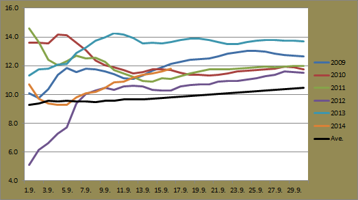
Other than the cold start to September in 2012, it's clear to see from the progressive average maximum graph below that daily maximums from 2014 have been unusually low so far this month. As mentioned in a previous post, Sydney Airport recorded three consecutive September days below 16C for the first time since 1995. September 8, 9 and 10 helped to increase the average by 1.8C though. The average has somewhat stabilised since then, increasing only slightly in the past couple of days.
Bureau of Meteorology forecasts up until September 23 show the average maximum holding steady alongside the long term average. The long term average maximum for September is 20.6C. If 2014 records the same value or lower, it will be the coldest since 1997. A couple of days in the high 20s towards the end of the month, something almost expected for Sydney during September, will change that though.
 |
| Progressive average maximum for September at Sydney Airport for the period 2009-2014 plus the long term average |
The minimum progression graph for Jyväskylä shows the average to be the lowest after 16 days of the month. Clear skies and dry conditions associated with recent high pressure systems over Finland have led to some rather cold overnight temperatures in the past few days. The past four minimums have measured between -1.4C (September 16) and 1.7C (September 13) leading to a noticeable dip in the average. While it's not the lowest September temperature since 2009, the -1.4C measurement from this morning is the earliest date after summer for the first recording below -1C.
Current forecasts show the average minimum for this September to close the month as the coldest since at least 2009.
After the first two days, which didn't climb above 14.3C, Jyväskylä has seen exceptional autumn warmth this September, especially considering the cold end to August. Only figures from 2013 rival this year, and the 2014 figure sits more than 4C higher than that of 2012.
 |
| Progressive average minimum for September at Jyväskylä Airport for the period 2009-2014 |
After the first two days, which didn't climb above 14.3C, Jyväskylä has seen exceptional autumn warmth this September, especially considering the cold end to August. Only figures from 2013 rival this year, and the 2014 figure sits more than 4C higher than that of 2012.
Temperatures will drop over the next week and based on current forecasts, we're likely to see the final average maximum end up as the second highest figure, somewhere between the 2009 and 2013 figures.
Something else to point out for Jyväskylä so far this September is that it has been exceptionally dry. After 16 days of the month, only 1.6mm has been recorded at Tikkakoski. The 1981-2010 monthly average is 55mm and September 2012 saw 101mm recorded. The record low for Jyväskylä is 8.8mm, from more than 100 years ago in 1901. No significant falls are forecast in the next 10 days either.
 |
| Progressive average maximum for September at Jyväskylä Airport for the period 2009-2014 |
No comments:
Post a Comment