Typically, summer in the Northern Hemisphere includes the months of June, July and August. For the sake of this post and analysis I've included May as well. The reason behind this is that May in Finland is very capable of producing warm days similar to those seen during the normal summer months. As some sort of support to that statement, Jyväskylä's highest temperature in 2009 was actually recorded in May.
The summer of 2014 in Jyväskylä was very warm. However, the overall figures and monthly averages between May and August don't necessarily tell the whole story.
May started off very cold. Then temperatures suddenly climbed to record highs, before quickly dropping just before the end of month. The average maximum for May was the lowest since at least 2009 and FMI figures put May 2014 very close to the 1981-2010 average.
After the first three days of June, temperatures briefly returned to those seen in mid-May. Just as quickly as they had arrived, they disappeared. The second half of June was cold, wet and generally quite miserable. FMI put June 2014 as the coldest since 2004.
Then came July. The first two days struggled to 15C, but real summer weather arrived on the 3rd. July 7, 8 and 9 each climbed above 26C. The rest of month saw beautiful, warm summer temperatures with any rainfall only associated with storm activity. The month wasn't quite as warm as that seen in 2010, but it was the sixth warmest since at least 1961.
August continued July's good run of warm temperatures, but they fell away quickly after the first two weeks. The average maximum from the first 15 days was 8.5C higher than that of the final 16. The early warmth helped August 2014 claim its place as the eighth warmest since at least 1961.
It was a summer of extremes; there were distinct periods of unusually cold temperatures along with periods of warm, and at times record, highs. The graph below shows the daily minimums and maximums at Jyväskylä Airport from the start of May until the end of August. The specific cold and warm segments of the summer are quite clear. For some comparison, the dotted line represents the averages from daily figures between 2009 and 2013.
 |
Daily minimums and maximums at Jyväskylä Airport between May and August 2014.
Dotted line represents daily averages from 2009-2013. |
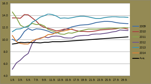
If we go deeper in looking at how the summer of 2014 compared to previous years, we can turn to the number of days with minimums above and below 10C. The graph below shows this.
 |
Jyväskylä minimums between May and August in the years between 2009 and 2014.
Blue represents minimums below 10C while orange represents minimums above 10C. |
This year was quite similar to 2010. There was an early block of days in May and an extended period from July into August where temperatures remained above 10C. In 2010's case, this period lasted 33 days. 2014 recorded 30 consecutive days above 10C. 2009 and 2012's lack of consecutive days above 10C is quite clear also.
 |
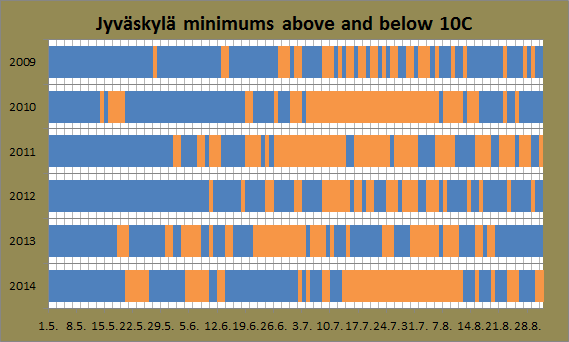
Jyväskylä maximums between May and August in the years between 2009 and 2014.
Blue represents maximums below 20C while orange represents maximums above 20C. |
If we look at maximums above 20C, 2014's distinct warm and cold periods clearly stand out. Unlike 2011, for example, where temperatures fluctuated a lot more, 2014 saw consistent runs of days above or below 20C.
It's also interesting to see how many days with a maximum above 20C that also climbed above 25C. 2009 and 2012, especially, had the highest number of days that failed to convert 20C days into 'hellepäivät'.
 |
Jyväskylä maximums between May and August in the years between 2009 and 2014.
Blue represents maximums below 25C while orange represents maximums above 25C. |
I think this graph in particular is a great indicator of whether the summer was a good one. 2009 and 2012 were clearly not great summers, recording only 2 and 8 days above 25C respectively. On the other hand, 2010, 2014 and even 2011 and 2013 were rather good summers. There plenty of days above 25C, and they occurred at different times during the summer.
Looking at the graph, you can't help but once again compare 2014 to 2010. Both had good runs of days above 25C. This time 2014 recorded the higher number of consecutive days, a total of 12 in July. Another run of 10 days above 25C was also seen. 2010's highest streak was 10.
Some statistics for summer 2014 include:
- Highest temperature at Jyväskylä Airport of 30.3C on July 25. (Finland's highest temperature was 32.8C in Pori on August 4)
- Lowest temperature at Jyväskylä Airport of -6.4C on May 7.
- Wettest day was May 26 with 28.1mm.
- The overall high from each month from May to August was above 28C, something not seen in the years between 2009 and 2013.
- The weather stations of Helsinki Kumpula, Kouvola Utti and Hattula Lepaa all broke the record for the longest streak of days above 25C. With recordings dating back to 1959, the record had been 22 from the summer of 2003. Now it stands at 26.
In the end, 2014's summer was an exceptionally good one. Despite some of the cold temperatures seen, warm days were fairly evenly spread and July and early August were especially good. Now we head towards the cold of winter...