In addition to the heavy falls, temperatures were also down. Sydney Airport's maximum of 22.6C at 1:30pm is the lowest of the month so far, and coldest since February 28. Within 20 minutes of that recording the storm had struck and the temperature dropped to 16.8C.
A storm had been threatening the city since the morning. Forecasts had also predicted heavy falls up to 45mm. In the end Sydney Airport received 39.8mm, eclipsing the March 13 total of 32.0mm. The graph below shows the cumulative rainfall during the afternoon. The first hour, especially, dumped a large amount of rain. This led to flash flooding in suburbs surrounding the Airport.
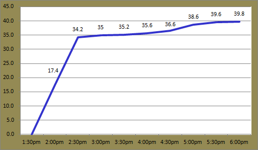 |
| Rain accumulation at Sydney Airport on March 24 2014 |
The highest rainfall recording in the Sydney region today was at Lucas Heights, south west of the city. 72.0mm fell there between 1:30pm and 8:15pm. The city avoided the worst of the rain; Observatory Hill recorded a comparatively low total of 6.8mm.
Sadly, one man lost his life at Lucas Heights after he was sucked into a drain while trying to clear it of debris. Two men were also struck by lightning in separate incidents in Cronulla and Mascot. More information plus photos of flooding can be found here.
Winds were also initially quite strong at the Airport. A gust of 72km/h was recorded at 2pm. This was the strongest gust since February 10. Showers and storm activity are likely to continue throughout much of New South Wales tomorrow.
The weekend in Jyväskylä saw mixed weather. Saturday was warm and dry. It reached 7.4C in the afternoon. Yesterday saw a few hours of rain though with 3.8mm falling at Jyväskylä Airport. Temperatures were also much lower; it only got to 2.4C.
Like Saturday, today was a dry and warm spring day. The mercury topped 8.7C and the skies were clear for almost the whole day. The rest of the week should see similar conditions with hardly a cloud in sight and maximums around 6C. Night time temperatures though could dip below -5C.
No comments:
Post a Comment