Monday, 31 March 2014

Month ends with more rain in Sydney, still dry in Jyväskylä

Once again a large storm hit Sydney yesterday evening. The worst affected areas of the city were from Bankstown extending north between Parramatta and Penrith and up to Hornsby. There were two particularly dangerous storm cells. One was situated in the Blue Mountains and moved north through Katoomba, while the other moved north just west of Parramatta.

The warning below was issued by the Bureau as the storm developed.
"The Bureau of Meteorology warns that, at 8:15pm, severe thunderstorms were detected on the weather radar near Parramatta, Katoomba and Richmond. These thunderstorms are moving towards the north. They are forecast to affect Hornsby, Blackheath and Glenorie by 8:45pm and Bilpin, Berowra and Wisemans Ferry by 9:15pm.
Large hailstones and heavy rainfall that may lead to flash flooding are likely.
32mm of rain was reported in 30 minutes to 7:35pm at North Richmond. 20mm was reported in 10 minutes to 8:10pm at Erskine Park. Golf ball sized hail reported from St Clair."
The radar image below shows the severity and size of the storm. The two main cells are clearly visible.

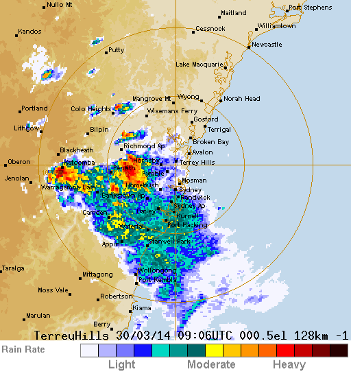
Terry Hills 128km rain radar image at 8:06pm AEST on March 30 2014
Source: Bureau of Meteorology (screenshot unedited from original image)

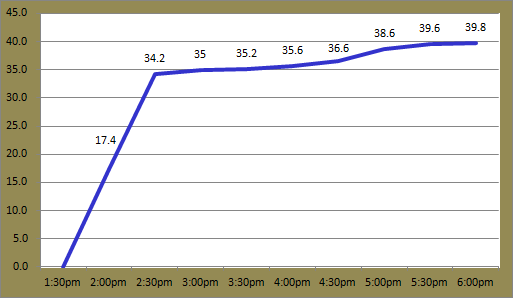
Sydney Airport and the city didn't receive a large amount of rain from the storm; 2.6mm and 3.6mm were recorded at the Airport and Observatory Hill respectively. Badgerys Creek in the west though had a recording of 39.8mm. Another 0.2mm fell this morning at the Airport, making it the 11th consecutive day of rain being recorded.

Jyväskylä continued its dry run with a pleasant weekend. Saturday got to 12.1C, the month's highest temperature. Highlighting that this is quite unusual is the fact that the highest temperature recorded in April last year was only just above that mark at 12.6C. Yesterday was much cooler though topping only 4.6C and today barely climbed above 2C. The dry spell endured its 8th consecutive day today, something not too common in Finland.

The next few days look to be a little cool like today, but the dry weather will continue before warming back up to 8C by Saturday.

Thursday, 27 March 2014

Similar weather continues in both cities

It might seem like Jyväskylä has stolen the sun from Sydney this week. Warm and sunny weather has continued throughout most of Finland while wet weather has continued on Australia's east coast.

Today was another sunny spring day in Central Finland. Temperatures climbed above 10C for the first time in almost 5 months. Today has also seen the biggest temperature difference since May 16 last year. It was -8.5C this morning, making it a minimum to maximum difference of almost 19C.

In the previous 5 editions of March, the highest temperature was 7.2C in 2011. Including today, there have been 7 days this month above that mark. Compared to March last year, this year currently has an average maximum almost 7C higher.

Clouds have almost been non-existent since the start of the week. Only this morning has seen any cloud in the last 72 hours. Even then the highest coverage across a 4 hour period was 5 oktas. Similar weather will continue tomorrow and on Saturday but a change on Sunday will bring cooler temperatures heading into next week.

Sunset on Tuomiojärvi, Jyväskylä on March 25 

Tuomiojärvi in the evening of March 25

Sydney's run of wet weather pushed into its 7th consecutive day today. A total of 17 out of the 27 days so far this month have seen rain recorded. After some smaller falls in the late morning yesterday, a large band of rain swept south through the city in the late evening and continued for most of the night. The radar image below was taken at 7:30am this morning. Rain continued for most of the day also.

Terry Hills 256km rain radar image at 7:30am AEST on March 27 2014
Source: Bureau of Meteorology (screenshot unedited from original image)

Despite the prolonged period of rain, measurements at Sydney Airport in the past couple of days haven't been greater than Monday's 39.8mm. Yesterday saw 17.2mm recorded and today added another 9.8mm to the monthly total, which now stands at 147.2mm.

Temperatures since the start of the week have also been lower than the previous few weeks. The past 4 days have an average maximum of 24.2C, compared to the overall monthly figure of 27.0C. Yesterday's 25.6C has been the highest this week.

Rain is forecast to continue tomorrow, although it shouldn't be as heavy as the previous couple of days.

Monday, 24 March 2014

Another big storm in Sydney, dry and sunny week ahead for Jyväskylä

Storms continued today in Sydney. Widespread heavy rain and lightning hit the city from just after midday. All weather stations throughout the Sydney region recorded rain with locations south of the city experiencing the biggest falls.

In addition to the heavy falls, temperatures were also down. Sydney Airport's maximum of 22.6C at 1:30pm is the lowest of the month so far, and coldest since February 28. Within 20 minutes of that recording the storm had struck and the temperature dropped to 16.8C.

A storm had been threatening the city since the morning. Forecasts had also predicted heavy falls up to 45mm. In the end Sydney Airport received 39.8mm, eclipsing the March 13 total of 32.0mm. The graph below shows the cumulative rainfall during the afternoon. The first hour, especially, dumped a large amount of rain. This led to flash flooding in suburbs surrounding the Airport.


Rain accumulation at Sydney Airport on March 24 2014

The highest rainfall recording in the Sydney region today was at Lucas Heights, south west of the city. 72.0mm fell there between 1:30pm and 8:15pm. The city avoided the worst of the rain; Observatory Hill recorded a comparatively low total of 6.8mm.

Sadly, one man lost his life at Lucas Heights after he was sucked into a drain while trying to clear it of debris. Two men were also struck by lightning in separate incidents in Cronulla and Mascot. More information plus photos of flooding can be found here.

Winds were also initially quite strong at the Airport. A gust of 72km/h was recorded at 2pm. This was the strongest gust since February 10. Showers and storm activity are likely to continue throughout much of New South Wales tomorrow.

The weekend in Jyväskylä saw mixed weather. Saturday was warm and dry. It reached 7.4C in the afternoon. Yesterday saw a few hours of rain though with 3.8mm falling at Jyväskylä Airport. Temperatures were also much lower; it only got to 2.4C.

Like Saturday, today was a dry and warm spring day. The mercury topped 8.7C and the skies were clear for almost the whole day. The rest of the week should see similar conditions with hardly a cloud in sight and maximums around 6C. Night time temperatures though could dip below -5C.

Thursday, 20 March 2014

Colder in Jyväskylä, not too much change in Sydney

Jyväskylä has seen a few cooler days this week compared to the previous month and a half. The past 5 days have all had daily maximums below 0C, the first 5 day period below 0C since January 29 to February 2.

After Monday's -17C, Tuesday morning was also quite cold, dropping just below -15C. It has been warming up during the days in comparison though. Yesterday was the coldest of the month so far with a maximum of -3.2C.

A decent amount of snow fell in Central Finland on Tuesday. A depth of 9cm was the recording yesterday morning. More snow is falling right now and it should continue until the early hours of tomorrow, but warmer temperatures up to 7C in the coming days mean the snow is unlikely to stick around for long. With 6C predicted and fresh overnight snow, it sounds like it'll be quite wet and sloshy in the city tomorrow.

Sydney Airport saw its warmest day of the month on Tuesday. It reached 30.8C making it the warmest day in 3 weeks. Yesterday was slightly cooler, down to 24.3C, but today was warmer again with 27.3C.

There has been some rain and storm activity around inland New South Wales and off the coast in the past few days but no falls have been recorded at the Airport or Observatory Hill. Some suburbs in Sydney's south west received falls yesterday. Locations in the Southern Highlands just south west of Wollongong received over 100mm.

The debate over whether to have the brolly handy or not looks like it will rage over the coming days if the current forecast is anything to go by. There is the potential for storms and rain throughout the Sydney region all the way into next week.

Monday, 17 March 2014

Chilly start to the day

Sydney and Jyväskylä had their coldest mornings for quite some time today.

Sydney Airport saw its lowest temperature in over 3 months. You have to go back to December 7 to find a colder day. It dropped to 15.3C at the Airport around 6am. This consistent run of warm days continued though as it hit 28.0C just after 3pm. Only 1 of the last 11 days hasn't had a maximum between 28.0C and 29.5C.

I wasn't able to check the temperature outside before I rode my bike to work this morning, but it certainly felt a lot colder than the past month or so. When I finally managed to look on the FMI website I was quite surprised to see that not too long beforehand it had dropped below -17C at Jyväskylä Airport. It was slightly warmer in the centre of Jyväskylä though, somewhere around -12C.

For Jyväskylä, this morning was colder than any day in February, typically the coldest winter month. January 31 was the last day below this morning's mark. It's a remarkable turnaround from last Thursday when it reached 9.4C, a difference of more than 26C.

Tomorrow will see a cold start in Jyväskylä again, but Sydney should return to minimums above 18C for the next week.

Sunday, 16 March 2014

Jyväskylä turns white again, more storms for Sydney

Jyväskylä woke up to the sight of white this morning. Like the revised forecasts predicted, Jyväskylä avoided most of the snow that fell in Finland yesterday.

The south of the country received decent falls. It fell as rain and wet snow early, but turned to snow later in the day. A bit over 10cm was recorded in some places like Lahti and around Helsinki. Jyväskylä didn't receive any snow until later in the night. A depth of 4cm was the measurement at Tikkakoski Airport this morning.

Also as predicted, temperatures have been much lower than previous weeks. It dipped to -5.0C this morning, the coldest temperature since February 26, two and a half weeks ago. Yesterday got to 3.4C, but it doesn't look like it'll go above 1C for possibly the next week.

Kauppakatu, Jyväskylä on the morning of March 16

There has been plenty of storm activity around New South Wales in the past few days. A brief but intense storm hit Sydney yesterday afternoon and a smaller one hit today. Sydney Airport recorded 9.6mm in about 30 minutes from 5:20pm yesterday. At Sydney Olympic Park 16.2mm fell in a similar time frame. Lightning interrupted the AFL game there as it passed through the area.

Strong and localised wind gusts accompanied the storm also. The weather station at Fort Denison in Sydney Harbour recorded a wind gust of 91km/h just after 5:30pm.

Storm front in Sydney on March 15
Source: User VeinyPickle, Reddit

Today's rain was not as intense as yesterday. It hit earlier in the day also. After hitting a maximum of 29.3C just after 11:30am, the reading at midday at the Airport was 28.0C. By 12:45pm though, it had dropped to 20.8C. A total of 3.8mm was recorded. Sydney Olympic Park again received one of the highest totals in the Sydney region with 7.4mm. Temperatures climbed again in the late afternoon around the city; it read 27.2C at the Airport at 5:30pm.

The next few days in Sydney look to be quite good. Sunny and warm conditions are expected.

Thursday, 13 March 2014

Heavy rain in Sydney this morning, forecast backflip for Jyväskylä

The early hours of this morning saw very heavy falls in Sydney's east. In only a matter of just over 4 hours, Sydney Airport received its highest daily rainfall total in almost 4 months. A total of 32.0mm fell from just before 1am until 5am; 20.6mm of that fell within the first 30 minutes or so.

Residents of Sydney may have noticed a fair amount of shower and storm activity off the coast in the past couple of weeks. A few hundred millimetres worth of rain has fallen 50-100km out to sea since the start of the month.

This morning, over 100mm fell off the coast between Sydney and Wollongong. On land, Observatory Hill recorded 27.8mm to 9am, also the highest 24 hour total since November, and Canterbury received a drenching with 48.6mm. That was the highest daily recording there since June 30 last year.

Temperatures were a bit cooler today at the Airport, breaking a 6 day streak above 28C. Observatory Hill managed to top 27.0C, but southerly winds kept the maximum down to 24.1C at the Airport. The daily minimum of 18.3C was also the lowest in more than a week.

Colder weather is still on the way for Finland, but revised forecasts today predict that Jyväskylä will miss the majority, if not all, of the snow that will arrive in the country's south on Saturday. In fact, FMI doesn't predict any snow for Jyväskylä in its current 5 day forecast.

Warm weather continued today. Temperatures this afternoon at Jyväskylä Airport managed to top yesterday's figure. It was 9.4C around 3:30pm. Today was the fifth consecutive day above 5C. The earliest time for such an achievement in the previous 5 years was the 5 day period between April 8 and 12 in 2010. 2009 didn't see such a 5 day period until April 21 to 25.

Tomorrow looks to be the last day above 5C for at least a week and a half. Winds should be a little stronger than normal as well.

Wednesday, 12 March 2014

Cool change on the way for Jyväskylä

Finns probably shouldn't get the outdoor furniture ready just yet. The current streak of warmer than average temperatures and the feel of spring looks like it will come to an end this weekend. There are only a few clumps of snow left in Jyväskylä and most of the roads and paths are dry thanks to 6 consecutive days above 4C.

Today has been the warmest of the month so far and the warmest since October 29 last year. It reached 8.5C just before 3pm. Yesterday got to 5.9C while tomorrow should also reach 8-9C. Not a single March day between 2009 and 2013 had a temperature recorded above 8C in Jyväskylä.

Elsewhere in Finland today, weather stations in Tampere and at Helsinki-Vantaa Airport almost hit 11C and at Jomala in the Åland Islands it got to 13C.

The gravel and small rocks placed on footpaths during the winter have been drying out over the last week. As a result, it has been incredibly dusty in Jyväskylä, and elsewhere in Finland. Warnings about poor air quality have been issued throughout this week while efforts to clean the streets have already started, something not typically done until late April. Air quality warnings can be seen via the Ilmanlaatuportaali website.

Those small rocks might come in handy this weekend though. Forecasts are predicting a cold change to hit some time on Saturday. Westerly winds should pick up on Friday before shifting to the east on Saturday and later to cold northerly winds during Saturday night. Temperatures will drop below zero and there should be snow throughout most of the southern half of the country from late Saturday and potentially all the way into early next week. I've seen reports predicting as much as 20cm of snow in some locations in the south.

Next week will be much cooler than the past few with long term forecasts showing temperatures dipping below -5C during the nights and up to only -2C during the day.

Monday, 10 March 2014

Warm weather continues

Both Sydney and Jyväskylä enjoyed warm weather during the weekend and today, although on a slightly different scale.

Today was the fourth day in a row above 28C at Sydney Airport. After Saturday's 28.6C, it was only just lower at 28.2C yesterday. Although still below 30C, today went a little higher to 29.5C. Today's minimum of 21.8C is now the warmest of the month, equal third warmest of the year, and the highest since February 12.

Wind speeds were moderate for most of today along the coast. Sydney Airport recorded a top gust of only 41km/h. There was a brief shower early yesterday morning, but otherwise no falls have been recorded in the past few days.

After the rain and wet snow of Saturday morning, the rest of the weekend turned out quite nicely for most of Finland. Temperatures topped 4.8C at Jyväskylä Airport on Saturday. It was warmer, and especially sunny in the afternoon, on Sunday with 6.6C. Today also reached 6.6C.

Continuing on from recent weeks, these temperatures have been well above average. As a comparison, March 9 last year ranged between -20.6C and -8.9C. In the past 6 years, this is earliest time for such temperatures as well. The 10C barrier was broken in Kokemäki yesterday, 40km south east of Pori. This was the first time in Finland so far this year. It reached 10.8C there in the late afternoon.

Forecasts of 7C and 8C for Jyväskylä are still valid for the remainder of the week. Early forecasts for next week though show a return to more typical March temperatures around 0-2C.

Saturday, 8 March 2014

No change for Jyväskylä, warm and slightly unsettled in Sydney

I feel like I've been saying it for quite a while now, but Jyväskylä's mild weather hasn't let up in the last few days. It reached 2.3C on Thursday and yesterday topped 4.7C. Cloud has been around for most of this week and humidity rose yesterday morning to around 90%.

A mixed front moved east across Finland yesterday between Oulu and Jyväskylä. In Jyväskylä there was a hint of rain in the air, but only 0.5mm was recorded at the Airport. Rain was mostly affecting areas north of the city where the front passed through.

Yesterday's daily minimum of 1.4C was also unusually high. Including yesterday there have been 9 days so far this year with minimums at or above 0C. That's compared to 2 in 2009 up until March 7, 1 in 2013 and none for 2010, 2011 and 2012.

Another band of precipitation moved east early this morning. Jyväskylä has seen more falls this time round. Between 3am and 8am 4.6mm fell and there is more on the way in the coming hours.

The next few days will see even higher temperatures. It could go as high as 7C in Jyväskylä in the coming couple of days and 8C is currently forecast for next Wednesday. The sun should also make a welcome appearance.

The typical, unsettled weather that Sydney usually sees towards the end of summer has finally been around during the last few days. There was some more storm activity in the Sydney region yesterday.

The 7 days prior to yesterday saw falls at the Airport. The Airport and city didn't see any falls yesterday, but a Severe Thunderstorm Warning was issued for suburbs in Western Sydney in the afternoon. Horsley Park received 13.0mm and 10.4mm was recorded at Badgerys Creek. Locations in the Blue Mountains received fairly heavy falls also. Mount Boyce, just north of Blackheath, received 38.2mm, the highest daily recording there since June 26 last year.

It reached 28.1C at the Airport yesterday and it was still almost 24C at midnight. Today got to 28.6C. The next few days should see pretty similar weather. There is the chance of showers and storms until mid-week.

Wednesday, 5 March 2014

Dangerous storm hits Sydney's Eastern Suburbs

Today was one of those days I wish I was in Sydney. It was a nice, warm day that topped 30.7C at the Airport and it ended with a spectacular and menacing looking storm.

A low pressure trough moved north-east across New South Wales today generating showers and storm activity throughout the state. Warm northerly winds took the temperature up in Sydney during the middle of the day, but around 4:30pm a southerly change preceded an intense storm.

As a storm cell developed south west of the Airport, the Bureau issued a Severe Thunderstorm Warning for suburbs surrounding Sydney Airport warning of lightning strikes, heavy rain and potential flash flooding. The screenshot below is of the Sydney rain radar image at 4:36pm.

Terry Hills 128km rain radar image at 4:36pm AEST on March 5 2014
Source: Bureau of Meteorology (screenshot unedited from original image)

To get an idea of what the storm looked like, check out the photos in this Daily Telegraph gallery.

Sydney Airport received 13.0mm in the hour between 4:30pm and 5:30pm and experienced wind gusts up to 59km/h, the strongest since February 10. Only 1.6mm fell at Observatory Hill as the Eastern Suburbs were the worst affected. Aircraft enroute to Sydney were also kept in a holding pattern until the storm moved on.

There may be more shower and storm activity for Sydney early tomorrow morning.

Tuesday, 4 March 2014

February 2014 Review - Jyväskylä

Jyväskylä experienced one of the warmest Februaries on record in 2014. Temperatures throughout Finland were well above average for pretty much the whole month. This article released by the Finnish Meteorological Institute states that southern and central parts of the country were 6-8C warmer than normal, while some places in the north were even 9C above average. Rainfall was fairly average, but because of such high temperatures, snow depths were some of the lowest on record.

The graph below shows February averages at Jyväskylä Airport during the last 6 years.

February averages at Jyväskylä Airport for the period 2009-2014

February 2014 was easily the warmest of the last 6 years. In fact, Jyväskylä saw its second warmest February since at least 1961. The average temperature of -1.4C was 7.1C higher than the 1981-2010 figure of -8.5C. Only 1990 had a higher average temperature.

The warmest temperature of the month of 5.8C came on February 24. That was the earliest date for such a high temperature in the past 6 years. The warmest minimum of 3.1C, also recorded on the 24th, was the highest figure of the past 6 years as well.

Cold days were rare. February 1 was responsible for both the lowest monthly temperature and the lowest daily maximum, -10.6C and -6.8C respectively. And as I mentioned previously, that was coming off the back of the 3 week cold snap in January.

The dates above were also responsible the highest and lowest monthly temperature at a national level. The highest temperature was recorded in Pori on February 24 when it reached 8.1C. The lowest monthly temperature was -37.5C, recorded at Kiutaköngäs, north of Kuusamo, on February 1.

There were 2 key observations during the month that really stand out. One was the lack of days below -10C, and the other was the number of days above zero. The graph below highlights this.

Number of  February days below -10C and above 0C for the period 2009-2014

Precipitation was slightly below average for the month. I made a plan at the beginning of the year to start recording daily precipitation for both Sydney and Jyväskylä, but there appeared to be some problem with the equipment at Jyväskylä Airport and the measurements via the FMI website were unavailable for most of the month.

Looking at the FMI records though, 25mm was recorded. That is compared to 22mm last year and the 1981-2010 average of 32mm. Due to the warm temperatures seen throughout this winter snow depths have been unusually low. On February 15 the depth was only 12cm, well below last year's 49cm and the average of 42cm. By the end of the month, most paths were clear of snow and were even dry.

Monday, 3 March 2014

February 2014 Review - Sydney

Temperatures in Sydney for February were slightly above average for 2014. It was slightly warmer than both 2012 and 2013, but cooler than 2010 and 2011. It was a little dry though with Sydney Airport recording just under half the long term average. Despite being rather dry, the average daily sunshine of 6.5 hours was below the long term average of 7.1.

The graph below shows February averages at Sydney Airport during the last 6 years.

February averages at Sydney Airport for the period 2009-2014 plus the long term average

Both the average minimum and maximum were the third highest since 2009. Like the previous 5 years, February 2014's averages were also above the long term figures of 19.0C and 26.4C.

February's warmest day was the 26th when it got to 34.9C, one of only 3 days of the month above 30C. The highest minimum of 22.3C came on February 12. This was the lowest of the past 6 years. The lowest monthly temperature of 15.9C, the second lowest of the past 6 years, was recorded on the 7th. The last day of the month was responsible for the coolest daily maximum of only 21.9C.

Sydney Airport saw a monthly rainfall total of 56.0mm, just under half the long term average of 113.3mm. It was the third driest February out of the last 10. Observatory Hill recorded 61.0mm, just over half the long term average of 118.3mm. The graph below shows the daily rainfall totals for the month.

Daily rainfall totals during February 2014

There were 11 days on which rain was recorded at the Airport. The wettest day was February 19 when a total of 23.2mm fell. That was due to a large storm that affected Sydney and surrounding regions late in the afternoon.

Only 3 days of the month recorded wind gusts over 60km/h. The 76km/h south-southwesterly gust on February 10 was the strongest of the month. This is the strongest of the year so far, but was below February 2013's strongest of 91km/h. Both February 14 and 18 recorded the weakest daily gust of 31km/h.

Sunday, 2 March 2014

Dry in Jyväskylä, wet in Sydney

Dry weather has continued in Jyväskylä during the last few days. Temperatures haven't been quite as high as early last week, but March has still seen an above average start to the month. The sun was out for most of yesterday as it reached 2.8C.

I said more than a week ago that the ice thickness has been decreasing, but as I found out yesterday, the ice on Jyväskylä's Jyväsjärvi is still thick enough to walk on.

Ice on Jyväsjärvi on March 1

Testing out the ice

Interesting patterns from old footprints

In Sydney it has been a wet weekend. Sydney Airport saw one of the lowest 3 day totals in the Sydney region. Since Friday 12.6mm has fallen there. Elsewhere in Sydney, Observatory Hill has seen 21.6mm since Friday while Bankstown Airport and Penrith saw greater 3 day totals of 39.6mm and 35.4mm respectively.

On the Central Coast north of Sydney there was flash flooding in localities around Lake Macquarie on Friday morning. The weather station at Cooranbong just west of the Pacific Motorway recorded a staggering 222.2mm throughout the day; 206.2mm of that fell in the 9 hours between midnight and 9am.