Monday, 29 December 2014

Cold in Jyväskylä but change coming, temperatures steady in Sydney

Cold conditions continued in Jyväskylä during the weekend and today. It has been mostly dry as well, with light snow on Saturday the only recorded precipitation since December 21.

In the far north, Inari saw a low of -36.4C around midday today. This is the coldest temperature seen in Finland this winter. Cold temperatures extended south all the way to Helsinki too. Helsinki-Vantaa Airport saw it drop below -20C this evening.

As for temperatures in Jyväskylä, since December 23, only Boxing Day saw the mercury climb above -5C. Even then it was only to -4.9C. Yesterday saw the third lowest daily minimum of the year. January 23 and 24 are the only days of the year to have dropped below -25C, to -27.3C and -27.7C respectively, but December 28 came fairly close. It dipped to -24.5C just before 11pm last night. 

Temperatures today didn't climb above -15C at Jyväskylä Airport until just after 6pm. A warm front will push east across Finland during tonight causing temperatures to climb across the next 30 hours. The climb will be fairly dramatic with forecasts predicting it to be 2C already in the early hours of Wednesday.

The front is also predicted to bring snow from around 2am or 3am tomorrow. Tikkakoski's snow depth still sits at 16cm but it remains to be seen how much will be left after the warmer temperatures arrive. Mild weather is forecast from Wednesday until Saturday morning, before temperatures should drop once again.

Sun accompanied the cold temperatures on December 29

Daytime temperatures hovered around -18C in Jyväskylä

Conditions have remained quite similar in Sydney during the past few days. The second half of December has seen the odd cooler day among warmer days, and the past weekend started in the same way. After a top of 27.4C at the Airport on December 26, Saturday only got to 22.2C, the second lowest daily maximum for the month. 

Yesterday saw a return to temperatures above 25C with a top of 26.2C, and today also reached 28.5C. Minimums have remained above 18C for just over a week now. The average minimum sits at 19.0C. It can drop to 18.9C in the final days of the month and it will still be the warmest average minimum for a December since at least 2009.

The coming week looks good. Other than New Year's Eve, which is still forecast to reach 24C, other days are all likely to reach maximums between 27C and 30C.

Thursday, 25 December 2014

Christmas weather in Sydney and Jyväskylä

Warm daytime temperatures and afternoon and evening storm activity returned to Sydney for Christmas Day this year. Despite Christmas Eve only just topping 23C at Sydney Airport, the rest of this week has seen maximums above 28C. It got to 29.4C today, the warmest temperature since December 8.

Minimums have also been up on figures from last week. Tuesday's 21.4C minimum was the highest since March 10's 21.8C. While the 21.4C minimum is the highest so far this month, compared to the previous five Decembers, only 2011 had a lower respective figure.

Storm activity built west of the Blue Mountains this afternoon. Penrith saw its first rainfall around 4pm as the front moved east. The rain reached Sydney Airport just over an hour later. At the forefront of the rain was a weak southerly change which dropped temperatures at the Airport around 6C in the hour following 4:30pm.

Rain wasn't especially heavy and therefore totals weren't high initially, but a steady flow of showers throughout the evening helped the Airport record 13.0mm by midnight. This is the highest daily total in two and a half weeks. Other locations around Sydney saw higher totals though. Terry Hills recorded 36.8mm, 35.4mm fell at Camden and Observatory Hill also saw a higher measurement with 28.6mm.

After a black Christmas for much of Finland in 2013, almost the whole country has seen a white one this time around. Even southern locations like Helsinki and Turku saw snow, some of it falling on Christmas Eve, the traditional day for Finns for celebrate Christmas. Jyväskylä's snow depth has remained around 15cm since the weekend. The precipitation streak ended at 17, and no days this week have experienced any falls.

Temperatures in Jyväskylä climbed from below -20C to just above -10C on Christmas Day

Lake ice has thickened quite a bit since temperatures dropped below -5C on December 22

As predicted, a high pressure system arrived over Finland earlier this week and temperatures have dropped dramatically since the weekend. Last Saturday, December 20, the maximum was 0.8C. Early this morning temperatures dropped below -20C at Tikkakoski for the first time since January 31. Yesterday's high of -12.5C was also the coldest maximum since January 30.

The past five days have seen the average minimum drop from -1.9C on the 20th to -4.4C by today. The average maximum has also dropped from 1.4C to -0.2C.

Clear skies are typically associated with these colder temperatures, and there have been a few breaks, but cloud has mostly dominated the past few days. Temperatures should remain cold until next week. At the moment it looks like the New Year will see a return of warmer weather, possibly back above zero.

Saturday, 20 December 2014

More snow in Jyväskylä, windy in Sydney

Jyväskylä continued its consecutive run of daily precipitation today. Snow this morning made it the 16th straight day on which rain or snow has fallen at Tikkakoski. The past few days have mostly seen snow and, as a result, the snow depth now sits at 16cm. This is the highest depth for the season so far. During the 2013/14 winter only a brief period in February had a greater depth. The maximum snow depth for the whole season was only around 18cm.

Despite 16 straight days of precipitation, totals haven't been especially high. Only December 6 and 17 so far have recorded a daily total above 4mm. The 17th had the highest with 5.4mm. The graph below shows the steady increase of the monthly total which now sits at 42.2mm up until 11am today.

Cumulative rainfall for December at Jyväskylä Airport up until 11am December 20

Temperatures have still been hovering close to zero, although more so on the minus side compared to the month's first couple of weeks. Thursday saw the temperature reach a top of -1.6C, the lowest maximum since November 22, while the minimums for the 17th and 18th were -3.3C and -3.0C, the lowest since December 2.

Earlier forecasts that predicted a cold change this weekend were slightly off by a couple of days. However, temperatures will drop at the start of the coming week and, at least for Central Finland, Christmas 2014 should be a white one. Additional snow is predicted to fall later today and tomorrow and with temperatures dropping and remaining below zero from today onwards, the snow will surely stick around. Forecasts currently show drops to -18C or so towards the end of next week.

Sun briefly peeked through the clouds on December 18

Dry conditions have lasted a week in Sydney, but more typical summer temperatures haven't really been seen since earlier in the month. At Sydney Airport, only four of the 12 days from December 9 reached or exceeded 26C. A maximum of 28.4C on the 15th is the highest from the period. 

Yesterday saw the eighth day so far this December with a strongest wind gust above 65km/h at the Airport. As shown in the graph below, since the start of last year only the month of October 2013 recorded more with nine. A gust of 80km/h from December 11 remains as the strongest of the month to date.

The monthly number of maximum daily wind gust recordings above 65km/h at Sydney Airport
(1 January 2013 to 17 December 2014)

Monday, 15 December 2014

Warm start to December in both cities

Both Sydney and Jyväskylä have seen an above average start to December. Warm and sticky weather punctuated by storms has been seen in Sydney, while temperatures in Jyväskylä haven't been anywhere near the lows typically experienced at this time of the year.

Three of the four progressive averages as seen below are the highest among the past few years. The average minimum for Sydney is the second highest.

Progressive average minimum for December at Sydney Airport for the period 2009-2014 plus the long term average

The average minimum for Sydney had continually been above 19C until yesterday, the 14th day of the month. Yesterday saw the coldest temperature so far this month, a minimum of 15.6C. Since 2009, 2010 was the only other year not to see a temperature below 15C in the first half of December.

Currently forecasted minimums for the coming week put 2014's line above that of 2010. The forecasts for recent days, however, have been slightly off. For example, the prediction for yesterday was for a low around 18C, yet it dropped more than 2C below that.

Progressive average maximum for December at Sydney Airport for the period 2009-2014 plus the long term average

Other than 2011, which holds the record for the lowest average maximum with 22.6C, other years saw fairly similar progress after the first two weeks and a similar final figure above the long term average. December this year saw the first eight days of the month surpass 28C at the Airport and the average held above 30C for a week long period after the 2nd. Temperatures have been a little cooler since the middle of last week though. The highest temperature between the 11th and 13th was only 23.5C.

Based on current forecasts, the average maximum will remain above the previous five years until December 20 when it dips below 2013's figure. There'll have to be plenty of hot days towards the end of this December for it to achieve record levels though. 2005's 29.5C is a fair way off the projected 27.3C by the 22nd.

Progressive average minimum for December at Jyväskylä Airport for the period 2008-2014

After two minimums below -5C to the start the month, the only two such recordings so far, the average minimum at Jyväskylä Airport has climbed to the top of respective figures after the first half of December. The lack of cold temperatures is clear. All of the remaining 15 days so far have failed to go below -3C. 2008 and 2011 saw the next nearest number with 9 days above -3C. 2010 and 2012 saw no minimums higher than -3C for the same period.

Cold temperatures may finally be on the way though. Forecasts have again been fluctuating quite a lot for the coming 10 days, but temperatures could drop to -15C or lower next Monday or Tuesday. If this forecast is correct the average minimum will drop below the figures from 2008 and 2011.

Progressive average maximum for December at Jyväskylä Airport for the period 2008-2014

For the average maximum, the orange line sits above the others once again. December 2014's warm start has seen only two days that remained below zero. And even then the coldest so far was December 1's -0.6C. For some comparison, in the first 15 days of December in 2009, 2010 and 2012 the coldest respective maximums were -17.8C, -18.9C and -18.8C.

The next few days should remain fairly mild with temperatures hovering around 0C or just below. A high of -8C is currently predicted for December 23 and that would help the average drop below that of 2011 and 2013. As I said though, the forecasts have been changing rather quickly in the past couple of days and there is a lot of uncertainty over temperatures following the end of this week. For example, yesterday the predicted maximum for December 23 sat at 3C.

Saturday, 13 December 2014

Remnants of Alexandra bring snow to Jyväskylä

Alexandra, the storm associated with a low pressure system in the North Sea during the week, has weakened in the past 48 hours while moving east, but it did bring an additional band of precipitation to Finland late last night and today. The southern half of the country has received the bulk of falls, which have included rain, wet snow and snow.

In Jyväskylä it was snow that fell. The snow depth at Jyväskylä Airport is currently sitting at 8cm. Only November 7 had seen a depth that great so far this winter season. Up until 5pm this afternoon 2.6mm of precipitation had been recorded at Tikkakoski. Today is the ninth consecutive day of precipitation, equalling the current highest run this year. Wind warnings were also in place yesterday evening, but gusts in Jyväskylä weren't especially strong.

Temperatures held above zero after midnight, but they dipped below the mark just after 9am this morning. Snow began falling after 8am and has continued for most of the day. The mercury hasn't dropped that much though, only as low as -0.8C so far today.

Light snow also fell during the early hours of December 12

Snow in Viitaniemi during the afternoon of December 13

Tomorrow could be the first day entirely below zero since the first day of month, but Monday through to Friday are likely to see plus temperatures again. Current forecasts are predicting a sharp drop in temperatures late next Saturday, or possibly Sunday morning. Whether that forecast holds until then remains to be seen.

Thursday, 11 December 2014

Mild December continues for Jyväskylä, cooler in Sydney

The start of December for 2014 has been rather warm for Jyväskylä compared to historically typical weather seen at this time of the year. Persistent and mild southerly winds have kept temperatures up and precipitation has been seen on nine of the 11 days so far.

Current averages for Jyväskylä are sitting at their highest level in comparison to the first 11 days of Decembers between 2008 and 2013. Only December 1 failed to go above zero and with every other day surpassing 1C, the average maximum sits at 2.2C. After 11 days of December only 2011 in the years since 2008 had seen a comparable figure of nine days above 0C. 2010 and 2012 didn't see any.

December 4's daily maximum of 4.3C sits as the highest of the month so far. It was the highest temperature seen in three weeks. 2009, 2012 and 2013 all recorded December maximums higher than that though.

Similar to those seen in November and December last year, a strong storm associated with a low pressure system has been causing dangerous weather conditions in the North Sea. The storm, named Alexandra, has been moving from Greenland in a southeasterly direction since earlier this week. It brought very heavy snow and wild winds over 150km/h to Iceland yesterday. The capital, Reykjavik, recorded a gust at 111km/h. This video taken there yesterday shows the blizzard conditions experienced.

Synoptic chart and temperatures for Europe at 2pm Finnish time on December 10
Source: Finnish Meteorological Institute

The United Kingdom and Ireland have been seeing the effects of the storm as well with strong winds, damaging waves and rain and snow. In Finland, strong southerly winds are being experienced throughout most of the country. Wind gusts in Jyväskylä topped 50km/h yesterday evening, some of the strongest seen for quite some time. Areas of Vaajakoski, 10km from the centre of Jyväskylä, lost power as a result of the winds.

Snow fell in Jyväskylä last night but temperatures above 2C today have melted almost all of it. Today is the seventh consecutive day on which precipitation has been recorded. So far this year there have been four other periods of seven or more consecutive days of precipitation at Tikkakoski. Falls haven't been especially high though. December 6's 5.1mm stands as the highest daily total of the month at the moment.

Strong southerly winds were experienced in Sydney today also. A gust of 80km/h was recorded at the Airport this afternoon at 1:36pm. It was the strongest since November 16. The winds helped keep temperatures down too. With a top of 23.1C, it was the coolest maximum in two weeks. Late evening temperatures dropped to 17.1C, also the coolest minimum seen since late November.

The cooler temperatures were accompanied by showers as well. Sydney Airport recorded 6.8mm late yesterday evening and a further 9.8mm has fallen today. Sydney Olympic Park continued its run as one of Sydney's top receivers of rain for the month with a further 11.2mm and 29.2mm yesterday and today.

Tuesday, 9 December 2014

Wrap-up of Sydney's early December storms

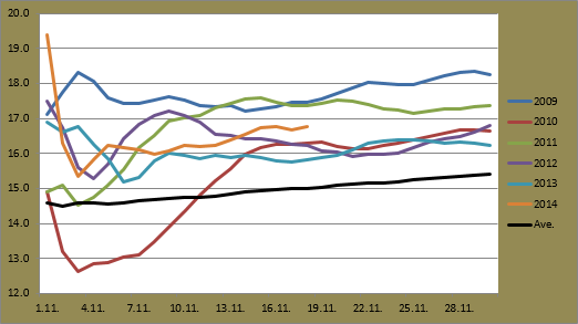
It has been a very warm start to December this year. Today, the ninth day of the month, was the first that failed to top 28C at Sydney Airport. Of the other eight, only December 6 didn't go above 29C and now the average maximum after nine days sits at 29.8C. The previous respective figure above that was in 2005 when the first nine days of December had an average maximum of 30.3C.

Today's maximum of 24.6C ended not only a run of 10 straight days above 25C, the longest since a 12 day run from January 10 to 21 earlier this year, but also a 10 day run above 27C. The previous higher number of consecutive days above 27C was 12, from January 28 to February 8 back in 2009.

The month so far has been characterised by these very warm temperatures, but also by the build up of storms west of Sydney and their subsequent movement towards the coast in the late afternoon or evening. The week-long period between December 2 and 8 has seen strong wind gusts, hail, very heavy, localised rain and flash flooding across the city. Some figures and more information from the past week are below.

December 2
The month's second day saw falls in the early hours of the morning. A total of 6.2mm was recorded at the Airport, the highest daily total since October 15. It reached 31.2C in the afternoon, making it the first day above 30C in just over a week.

December 3
December 3 saw storm activity build during the early afternoon. Maximums around the city for what is the warmest day of the month so far included 33.1C at Sydney Airport, 36.5C at Badgerys Creek, while Richmond saw the highest temperature of the Sydney region with 37.7C.

Storms arrived just before 5pm in the west. Richmond saw an 80km/h wind gust at 5:02pm. A gust of 72km/h was also seen at the Airport 25 minutes later at 5:27pm. There were heavy falls in the west. Horsley Park, about 35km west of the city, saw the highest total in the region with 46.4mm. Sydney Olympic Park recorded 36.6mm while Observatory Hill saw 23.6mm. Only 9.2mm fell at the Airport.

December 4
Temperatures fell just short of 30C on Thursday December 4. Storms built more slowly and from a later point in the day compared to Wednesday. Their arrival to the Sydney region wasn't until later in the evening. From 10:30pm to 12:30am December 5, Sydney Airport recorded 21.4mm.

December 5 
Friday afternoon saw a very menacing looking storm hit the city. The Airport was spared heavier falls though as only 0.8mm was recorded there during the whole day.

December 5's storm approaching the city as viewed from Bondi Junction
Source: Reddit user h3ndofry - Imgur

The view of the storm from Circular Quay as it charged east over Sydney Harbour
Source: Reddit user kalvin74 - Imgur

The leading edge of the storm in Mona Vale on Sydney's Northern Beaches
Source: Reddit user It_Is_Known - Imgur
December 6
The weekend continued in the same fashion as the previous few days. It reached only 28.5C at the Airport, breaking a run of six days above 29C. Once again storms built in the mountains, this time to the north west of Sydney and headed in a southeasterly direction. Many locations around Sydney recorded their highest daily totals of the month so far. Sydney Olympic Park saw 39.4mm between 9am and midnight. Richmond recorded 33.6mm and the Airport 16.4mm.

A total of 49.6mm fell at Penrith. The Bureau of Meteorology's 49.6mm recording to 9am on December 7 was the highest 24 hours to 9am total there since January 29 last year.

December 7
Sunday was rather similar to Saturday with a storm in the late afternoon. Homebush again bore the brunt of the heavy ran with 44.2mm; 41.6mm of which fell between 4:30pm and 5:30pm. The Airport received 23.8mm in the hour between 5pm and 6pm. 24.2mm had fallen by midnight, the highest daily total of the month so far.

Earlier in the day, just after 12:30pm, Camden saw wind gusts up to 89km/h. The previous strongest gust was recorded almost exactly a year ago; December 5 2013 saw a gust of 106km/h.

December 8
Monday December 8 finally saw some respite for the city. A few showers were around in the morning and the Airport recorded 1.6mm between 6:30am and 8:30am. Temperatures climbed to 32.7C just before 1pm. A brief storm added a further 1.2mm to the daily total and a 76km/h wind gust was also recorded.

The seven day period above is the longest rain period since the beginning of September. With the monthly total at the Airport now standing at 81.2mm, it is also the wettest start to a December since 1992. Over 100mm was recorded in the first eight days then.

Other totals around the city so far this month include 162.0mm at Sydney Olympic Park, 137.8mm at Richmond, 111.6mm at Penrith and 103.2mm at Camden. Observatory Hill has escaped some of the heavier falls and its total currently sits at 65.8mm.

The coming week should see further falls around Sydney with showers increasing tomorrow to rain by Thursday. Temperatures will be a little cooler, but should still be comfortably above 20C.

Friday, 5 December 2014

November 2014 Review - Sydney

It was a very warm and dry November for Sydney in 2014. More than half of the month saw daily maximums exceed 25C and a new record for the lowest daily maximum helped Sydney Airport record the fourth warmest average maximum on record. The threat of storms was evident at times during the month but the Airport escaped heavier falls like those seen in Western Sydney. This led to November 2014 being the fifth driest on record.

The average minimums and maximums from the past six years plus the long term average are shown below.

November averages at Sydney Airport for the period 2009-2014 plus the long term average

At 2.3C above the long term average, 2014's average maximum was the fourth warmest for a November since 1939. 2009 holds the record with 27.2C. The figures of 26.7C from 1968 and 26.5C from 1957 are the second and third warmest. Using Bureau of Meteorology methods, the average minimum for the month sat at 17.9C. This is the second highest on record. 2009 also holds this record with a figure of 18.5C.

The coldest temperature of the month was, unsurprisingly, earlier on. The morning of November 2 dipped to 13.2C. Of the past six years, 2009 and 2011 recorded warmer figures. The highest minimum came on the 24th. It never dropped below 21.0C then. Again 2009, as well as 2010, had a warmer respective figure.

The month's hottest day was November 14 as it reached a top of 38.0C. November 1 and 21 also passed 35C, with both on their way to 37.0C. The 38.0C recording was the hottest November temperature since 42.5C was recorded on November 22 back in 2009. 2009 also recorded another day above 38C, but you have to go back a few more years to 2006 to find the next occurrence prior to that.

The new record set for November at Sydney Airport was the lowest daily maximum. The 27th was the coolest day reaching only 21.1C. Only two Novembers since 1939 had seen a lowest maximum at 20C or above. The previous record was held by 1997 when the coldest day was 20.2C.

The month saw six days top 30C at the Airport. As mentioned above, three of those six climbed above 35C. The record number of days above 35C for a November is four, jointly held by 1957, 1967 and 1968. Of the Novembers since 1968, 1980, 2002, 2004 and 2009 also recorded three days above 35C.

Daily minimums and maximums against rainfall at Sydney Airport for November 2014

The month was very dry at the Airport. The calendar month saw 15.2mm recorded. The Bureau's recording of 13.2mm (2.0mm recorded against December 1) is the fifth lowest since 1929. 1956 holds the record there with only 5.7mm, and this year's figure (13.2mm) was the lowest since 1962. Other locations around Sydney, especially in the west, saw greater monthly totals due to isolated storm activity. Sydney Olympic Park recorded 38.0mm while Penrith saw 40.0mm, 30.0mm of which came in the 24 hours to 9am on the 6th.

There were only seven days of rain. The 16th was the wettest day, but only 5.8mm fell then. In 2014, only January and July have had a wettest day of the month drier than that. November 6 to 15 saw no rain and that 10 day period was the longest dry streak. It was also the longest dry streak since the 22 day run from late June into early August. There were two occurrences of two consecutive rain days, November 1 and 2 and the 24th and 25th. They only accounted for 1.2mm and 2.4mm respectively though.

Winds were down on last year's figures once again. The average maximum daily wind gust for November 2014 at the Airport was 52.4km/h and there were six days with a maximum gust above 60km/h. This is compared to 53.9km/h and nine days last year.

The strongest gust of the month, however, was stronger. The 16th recorded a maximum gust at 85km/h from the west. Two days earlier, a south-southwesterly gust at 83km/h was also measured. November 2013's strongest gust was 78km/h. The calmest day was the 24th when the strongest gust was only 35km/h from the east.

Wednesday, 3 December 2014

November 2014 Review - Jyväskylä

Jyväskylä experienced a cooler November in 2014 compared to some recent years, but figures were still above the long term average. Large portions of the month were spent hovering just above or below zero and it saw only a few minimums below -5C. Other than November 1 and 30, there was no sign of sunshine, but even with the increased cloud cover, precipitation was slightly below average.

The average minimums and maximums for November since 2008 are shown below.

November averages at Jyväskylä Airport for the period 2008-2014

November 2010 is clearly different from other Novembers since 2008. For reference, the overall average from 2010 was 2.5C below the 1981-2010 average of -2.0C. The Finnish Meteorological Institute reported that the average for November 2014 in Jyväskylä was 0.1C, 1C less than last year's 1.1C. 2014 is the fourth consecutive year with an average more than 2C above the long term figure. In fact, 2010 is the only year to record a below average figure since 2005. 2014 was, however, cooler than 2008, 2009, 2011, 2012 and 2013.

The highest temperature of the month came on both November 3 and 4. Warm and wet conditions saw 9.7C recorded either side of midnight on both days. This was the third highest temperature seen in a November since at least 2008. The first two days of November 2011 saw highs of 10.5C and 10.6C. The figures from other years sit between 7.2C and 7.9C.

November 3 also saw the highest minimum with 8.3C. Along with November 4's low of 7.4C, these were warmer than any minimum seen during a November since 2008. 2011 was the only other year to see a highest minimum that wasn't 5C or below.

As Jyväskylä headed into winter, it was strange to see that the first day of the month was responsible for the coldest temperature. It dipped to -9.5C then. Every November since at least 2008 recorded a minimum below -10C. Even the past October saw three minimums below the mark. The coldest day did come later in the month though. The 21st saw a top of -3.9C. This was still rather warm compared to other years though. Only the coldest November days from 2009 and 2013 were warmer.

As the graph below shows, temperatures fluctuated very little in the second half of the month. So while there were 22 days with a minimum below 0C, the second highest such figure since 2008, there were very few really cold minimums. There were only five minimums below -5C. Only 2012 saw fewer. On the other hand, the number of days that failed to top zero, 12, was also the second highest in the past seven years.

Daily minimums and maximums against rainfall at Jyväskylä Airport for November 2014

Cloud dominated the month (there was less than eight hours of sunshine), but the 50.6mm monthly total was below the 1981-2010 average of 54mm. FMI recorded 43mm for Jyväskylä, compared to 75mm last year. Most of the precipitation fell as rain or wet snow, but there were a few days with proper snow, especially earlier in the month. November 7 recorded a snow depth of around 8cm. The depth never went above 10cm though.

There were 17 days on which falls were recorded at Tikkakoski. November 4 and 11, with totals of 10.1mm and 10.2mm respectively, were the wettest days and accounted for 40% of the monthly total. The highest consecutive number of rain days was seven, from the 9th to the 15th, and accounted for 17.0mm. The following six day period to the 21st was the longest dry streak.

The month ended fairly warm. If we try to compare November 2014 to one from the previous six years, the closest would be either 2008 or 2012. The mildness of November 2008 carried on into December, but 2012 saw temperatures drop fairly dramatically around the turn of the month. What will happen in December this time?

Monday, 1 December 2014

November ends with sun in Jyväskylä, unsettled weather in Sydney

The sun still exists! It was finally sighted once again in Jyväskylä during the weekend. Yesterday was the first day that the sun shone in just over four weeks. Funnily enough, the first and last days of November were the only days of the month on which Jyväskylä was bathed in sunshine.

If people in Central Finland had been thinking it was a cloudy and grey November, they were right. As this YLE article points out, Jyväskylä saw just under eight hours of sun, less than a third of the average sunlight hours for November. Helsinki was also well below average, but in the north, Sodankylä experienced an above average amount with 23 hours.

The clear skies dropped temperatures in Jyväskylä to -4.0C yesterday morning. That was the coldest temperature seen in a week and interrupted a run of four consecutive days at or above zero. November 27, 28 and 29 all saw very similar maximums; 2.0C, 1.9C and 1.8C respectively. It wasn't until Saturday evening that the temperature dipped closer to zero. The final three days of the month remained dry also.

The start of December doesn't look to be very good weatherwise. Temperatures will hover around zero in Jyväskylä, possibly climbing over 3C on Wednesday and Thursday, and minimums currently aren't expected to drop below -3C for the coming 10 days.

The last day of November saw blue sky in Jyväskylä for the first time since November 1

Frost also accompanied the sun

Unsettled conditions are being experienced in Sydney at the moment. A series of low pressure troughs developed across the country during Thursday and Friday last week and have been moving east over the weekend. As is typical with low pressure troughs, storms and showers have been associated with their eastward movement.

Sydney Airport saw 2.0mm during the evening of November 30 as storms passed through the city. Locations in the west saw more intense falls. Richmond and Camden recorded 18.2mm and 17.6mm respectively.

The last parts of this evening's storm are currently moving through the city. No rain fell before midnight at the Airport, but 4.8mm had been recorded by 4:30am on December 2. Interior parts of Western Australia, South Australia and the Northern Territory are seeing very large storm fronts with lightning and rain also as these troughs head east.

More falls are likely in the coming days in Sydney as warm and moist air crosses New South Wales. Forecasts predict similar conditions to those seen yesterday and today, with daily maximums just below 30C for the next four days. The threat of afternoon and evening storms and rain is also clear. In fact, while the coming weekend looks to be a little cooler, down to 25C, the next seven days each show at least a 60% chance of rain.

Thursday, 27 November 2014

Slight change in temperatures this week

After a decent run below zero, temperatures in Jyväskylä climbed above the mark earlier this week on Monday. Other than a brief drop to -0.1C on Tuesday, they've remained on the plus side of the scale since then. Tuesday's 2.0C maximum was the warmest since November 12 and yesterday's 1.6C minimum was the first above zero in just over two weeks.

The recent figures aren't really at either the extreme end of hot or cold, but they are above average for this time of year. For some comparison though, November 27 in 2010 recorded daily figures ranging from -15.8C to -10.0C, while November 25 in 2011 recorded daily numbers of -1.9C and 7.0C.

Another interesting observation from the past couple of weeks is that since November 12, not one day has seen a difference between the minimum and maximum exceed 5C. November 20's 4.4C difference is the highest in the two week period, and excluding that figure the average difference is only 1.8C. This has meant very consistent temperatures during each day with very little fluctuation. During the whole period the lowest temperature recorded has been -5.9C, while the highest is yesterday's maximum of 2.8C, meaning a difference of only 8.7C between November 13 and 27.

The warmer temperatures this week have caused pretty much all of the snow that was on the ground to disappear. Only a few isolated clumps remain around the city. There has been a bit of drizzle around this week as well. Tuesday, yesterday and today have seen respective figures of 1.1mm, 0.6mm and 1.0mm.

Sun? Well almost. November 27 started off dry but drizzle arrived later in the afternoon.

Sydney Airport saw its coolest day of the month today. It reached only 21.1C just before 2pm this afternoon, just below November 6's maximum of 21.2C. It also ended an eight day streak above 25C. It does mean, however, that Sydney Airport has currently not recorded a daily maximum below 20C this November.

Only twice before in the station's 76 year history has this happened for the month of November. 1997 was the most recent occurrence when the lowest daily maximum was 20.2C. 1972 was the other with a figure of 20.0C. With only a few days of the month remaining and forecasts showing daily highs at 24C tomorrow and 27C and 30C for the weekend, this will be a new record for Sydney Airport.

This current run of maximums above 20C has also extended to 37 days. The highest such streak in the second half of a year since 2009 is 50 days. November 7 to December 26 of 2010 all recorded maximums above 20C. 2013 had the second highest number with 43, while 2009 had the lowest with 25. Based on current forecasts, 2014 will at least surpass 2013's figure.

One thing that I missed last week was that November 20 was the first day with a minimum above 20C since the last summer season. March 26 was the previous occurrence. November 20 is actually the equal latest date for such a recording in the years since 2009. 2009 also recorded its first minimum above 20C on November 20. Other years recorded their first occurrence in early November, although 2013 saw it already on October 23.

Lastly, Brisbane was hit by a very powerful storm this afternoon. Very strong wind gusts, large hail and heavy rain struck the city area. There were reports of it being the strongest storm in more than a decade. The Brisbane weather station recorded almost 40mm in only 30 minutes from 4:30pm onwards. Images can be found here while some video footage can be seen below.


Monday, 24 November 2014

Very warm weather in Sydney, a bit of snow and around zero in Jyväskylä

Warm summery temperatures continued in Sydney today with the sixth consecutive day above 25C. Four of the past six have also either been at or exceeded 30C. Showers and storm activity arrived this afternoon though.

Friday November 21 was especially hot. The daily maximum equalled the second highest seen this month and year, as it got to 37.0C at the Airport. It was hotter in the west. Badgerys Creek saw a top of 39.6C, Penrith 40.5C, while Richmond topped the region with 40.7C. Observatory Hill was a little cooler at 33.9C.

Saturday was a little cooler even though it still topped 26.1C at the Airport. On Sunday Western Sydney experienced even hotter temperatures than on Friday. Penrith recorded a reading of 44.9C. Records only began at the Penrith Lakes station in 1995, but this was the fifth highest measurement on record. At Richmond the mercury pushed to 45.3C. This was only the second time in that station's 21 year history to go above 45C. It was much cooler on the coast though. Observatory Hill only got to 30.1C while it reached 33.0C at the Airport.

Sydney Airport reached 30.0C this afternoon and it was warm across the city once again. Showers and storms had been building west of the Blue Mountains though and they arrived around 4pm. It had been just over a week at the Airport without a drop of rain. The initial burst didn't bring much and even by midnight only 1.6mm had been recorded. Additional rain, however, is currently passing through the city and another 0.8mm has been seen up until 3:30am.

Other locations around Sydney experienced more rain and stronger wind gusts. The RAAF base at Williamtown, just north of Newcastle, recorded a 98km/h gust at 4:48pm. Only 18 minutes earlier a gust of 19km/h was measured. Temperatures dropped 7C there in a only few minutes also as a storm cell passed through the area.

The view of the November 24 storm from North Ryde
Source: Reddit user InnerCityTrendy - Imgur

Temperatures in Jyväskylä remained below zero from late on November 19 until this morning. Both the 20th and 21st dipped below -5C for the first time in two weeks. The 21st only went as high as -3.9C and, based on current forecasts, will probably remain as the coldest day this month. It was also the lowest maximum since the -4.8C recording from February 6.

Like Sydney Airport, Tikkakoski went several days without any precipitation; six in total. Such a stretch was last seen more than a month ago. It ended on Saturday as snow fell in the early hours of the morning. A total of 1.6mm was recorded during the day and led to maybe 2cm of snow around the centre of Jyväskylä. An additional 0.1mm yesterday took the monthly total to 47.8mm.

Jääpallo (bandy) practice at Viitaniemi Field in Jyväskylä on November 22

Temperatures climbing above zero today to almost 1C have led to slosh and much of the snow disappearing. Conditions in Jyväskylä recently have been very cloudy. It has been just over three weeks since clear sky was seen over the city. I can't recall even seeing a bit of sun since the sunny weather on November 1.

Wednesday, 19 November 2014

November not giving any hints for the coming winter in Jyväskylä

As I mentioned yesterday in the November progression post, daily maximums in Jyväskylä this month, despite being somewhat average in the long run, have been a bit strange compared to previous years.

Warm days were common in the first 12 days of the month with eight of those exceeding 5C. The warmest November temperature since 2005 was also seen. Other than that though, maximums have been mostly below 0C. In between temperatures have been rare. Only three days have recorded maximums between 0C and 5C, and those three readings were all below 1C. This differs quite a lot from the previous six Novembers.

As the graph below shows, there have been eight days apiece for maximums below 0C and above 5C so far this November. The below 0C figure is clearly the highest of the past seven years, while the 2014 figure for days above 5C sits fairly high also, alongside 2011 and 2013.

Number of daily maximums at various levels at Jyväskylä Airport as of November 19 for the years 2008-2014

I've been looking at the daily figures quite closely since mid-September, trying to see if there's a connection between the warmer years and the cooler years, but 2014 doesn't seem to want to give itself away just yet.

As I've mentioned before, both 2011 and 2013 carried their rather warm October and November temperatures into December, and even into early January of the following year. The columns for 2011 and 2013 in the graph above are quite similar.

In contrast, 2009, 2010 and 2012 saw fewer days above 5C at this time of the year, with both 2009 and 2010 recording the second and third most number of days below 0C. Each of these three years went on to record very cold Decembers.

2008 saw a comparatively cold November despite recording only one maximum below zero, but the subsequent December was similar to those seen in 2011 and 2013.

Let's have a look at the minimums for the first 19 days of November in the past seven years.

Number of daily minimums at various levels at Jyväskylä Airport as of November 19 for the years 2008-2014

The columns for 2014 in the above graph look a lot more similar to those of 2009 and 2010. 2012 is somewhat surprising here as December was cold even from the very beginning. Temperatures did drop towards the end of November in that year though.

2011 and 2013 unsurprisingly have tall red columns, the number of the days with a minimum above 0C, with either only one or no days below -5C after the 19th day of the month.

If we based a winter prediction solely on the graphs above, it would be fair to say that the winter of 2014/15 will be a cold one. Long term forecasts released by the European Centre for Medium-Range Weather Forecasts (ECMWF), however, predict a warmer than normal winter. Northern Europe is forecast to see temperatures a couple of degrees above average.

Tuesday, 18 November 2014

November 2014 progress fairly average compared to previous years

Sydney has seen some pretty unusual daily maximums so far this November. After a 37.0C recording on November 1, the hottest day of the year to that date, the Airport went on to record 12 straight daily maximums between 21.2C and 26.0C. That consistent run, however, and the fact that all 18 days of the month have registered a top above 20C, have ensured that the average maximum has remained above 24C. November 14's 38.0C maximum jumped the average almost 1C, and after 18 days of the month it sits at 25.3C, equal with the figure from 2009. 

A very warm run of weather in the coming week, which currently includes four days with a forecast above 30C, should help November 2014's average stay in touch with 2009. The average maximum from that year of 27.2C is the current record for the Airport. Next on the list is the 26.7C reading from 1968.

Progressive average maximum for November at Sydney Airport for the period 2009-2014 plus the long term average

Minimums at Sydney Airport have been fairly average compared to those seen in the previous five years. 2010, 2011 and 2012 had already seen a minimum above 20C by this point, but the lowest temperature of this month so far of 13.2C sits above the respective figure from 2010, 2012 and 2013.

Current predictions for the coming week also suggest the average minimum to sit just below 2009 with only a few days of the month remaining.

Progressive average minimum for November at Sydney Airport for the period 2009-2014 plus the long term average

Daily maximums in Jyväskylä so far this month have also been a little odd compared to previous years. They have either been rather warm for this time of year, or then below zero. After 18 days of the month in 2014, Jyväskylä has seen only two days where the maximum was between 0C and 5C. There have been eight days apiece for maximums below 0C and above 5C.

In the end, it's not that surprising to see that the progression of 2014's average maximum has been in the middle of previous years. After 18 days it is currently the third lowest figure, almost smack bang in the middle of the highest figure from 2011 and the lowest figure from 2009.

Current 10 day forecasts suggest that maximums will continue just below zero. If that is the case until the end of the month, the average maximum for November 2014 will decline in a fairly similar fashion to that seen in the past two or three days and rank as the second coldest since at least 2008.

Progressive average maximum for November at Jyväskylä Airport for the period 2008-2014

The average minimum at Jyväskylä Airport currently sits at -1.4C, again almost right in the middle of the progressive averages from 2009 and 2011. More than half of the 18 days have gone below 0C, but the -9.5C minimum from November 1 remains the coldest. Only two other days have dropped below -5C. November 3 and 4 saw the two highest November minimums seen since at least 2009, meaning the average has remained a little higher despite the sub-zero temperatures.

With minimum temperatures predicted to remain below 0C, but not drop below -5C probably until the end of next week, the average for November 2014 looks like it'll end up somewhere similar to that of 2008.

Progressive average minimum for November at Jyväskylä Airport for the period 2008-2014

Friday, 14 November 2014

Very hot in Sydney today, holding steady below zero in Jyväskylä

Today saw the highest temperature at Sydney Airport in almost two years. Forecasts for the city predicted a top of 33C, and while Observatory Hill was close to that with a top of 32.2C, Sydney Airport smashed that prediction by 5C as it soared to 38.0C this afternoon.

The 38.0C maximum jumped over the 37.0C from November 1 as the hottest temperature of the year so far. It also exceeded the previous hottest day from last December when it reached 37.8C. That makes today the hottest at the Airport since the record high of 46.4C from January 18 last year. It was also the hottest November temperature for the Airport since November 22 in 2009.

Sydney's west was even hotter. The weather stations at Badgerys Creek, Camden, Horsley Park, Richmond and Penrith, as well as Williamtown, just north of Newcastle, all recorded maximums above 40C. This was the first day since last summer that exceeded 40C in all of those locations. For example, Penrith's last day above 40C was January 18. The daily top for the Sydney region was shared by Penrith and Richmond with a recording of 40.9C.

A strong southerly change hit the city late this evening. A gust of 83km/h was recorded at the Airport just after 9pm. Temperatures dropped around 10C over the course of an hour. This was the strongest gust so far this month.

The hot weather seen today was a bit sudden after a fairly cool period since the first day of the month. Sydney Airport went 12 days without exceeding 26.1C; the first time for such a figure during a November since 2001. Dry weather has also continued. Today marked the ninth straight day without rain. It shouldn't continue too much longer though as rain is forecast late tomorrow and for Sunday.

Temperatures ducked back below zero in Jyväskylä late on Wednesday afternoon. Since then they have remained below the mark, other than a brief period yesterday when it reached 0.0C exactly. It hasn't been too cold though, with this morning's -2.5C the coldest since last Saturday November 8. That has meant a temperature fluctuation of less than 2C today.

The city has received a very light dusting of snow since Wednesday evening. A small amount of precipitation has been recorded at Tikkakoski on each of the three days from Wednesday until today. That pushes the current rain day streak to six. Tuesday November 11 saw 10.2mm, beating the 10.1mm from November 4 as the highest daily total so far this month. It was also the highest daily total in just over three weeks.

Monday, 10 November 2014

Few days of snow in Jyväskylä, a little cooler in Sydney

The first decent snowfall for the 2014/15 winter period arrived in Jyväskylä at the end of last week. Snow started falling just after midnight on Friday the 7th and continued into the morning and past midday. By the middle of Friday afternoon there was around 8cm in Jyväskylä and its surrounding areas.

Low temperatures between Thursday and Saturday, which led to the first string of three consecutive days below -1C since March 18 to 20, helped the snow remain, but warm, at first westerly and then southerly, winds in the early hours of Sunday pushed temperatures above zero. They continued to climb throughout the day and topped 5.3C just before midnight last night.

Overnight temperatures weren't especially low during that three day period from the 6th to the 8th. They hovered around -2C, with -3.1C and -2.6C the figures for the 7th and 8th. Going back to the statistic of three consecutive days below -1C; since 2009, only 2012 had seen such an occurrence this early in the winter period. In contrast, the winter of 2011/12 didn't see it happen until the New Year.

Precipitation from the snowfall on Friday amounted to 5.3mm. Humid and misty air on Sunday also contributed 0.8mm to the monthly total, which now stands at 30.1mm. That's already more than half the long term average for November of 54mm.

After temperatures climbed yesterday they have remained above 3C until at least 8pm today. The warmth has meant that almost all of the snow from last Friday has melted.

Snow in Jyväskylä on the afternoon of November 7

The first decent snow for the season led to good coverage through most of Central Finland

Sydney Airport registered its ninth consecutive day below 26.1C today. Such a run for November hasn't been seen since the latter part of the month in 2003. The streak is likely to continue for at least another two days with forecasts in the low to mid-20s until Friday. The last streak of 11 or more such days was in 2001. The first 16 days of that November failed to exceed 25.3C.

On the other hand, despite not reaching 26.0C more than twice so far this month, there have been no days that failed to top 20C. 2005 was the last November in which all of the first 10 days exceeded 20C. If we look at minimums, today's 17.7C was the third warmest of the month. The figures so far this month haven't been exceptionally high or low.

More storm activity was seen in Sydney on November 5. Sydney Airport recorded 3.8mm, pushing the monthly total to 5.0mm. Once again, other locations throughout the Sydney region received higher levels as isolated pockets of the storm dumped heavy rain. Since last Wednesday though, there hasn't been any rain seen at the Airport. Since 1961, only five Novembers had seen a drier start to the month. A total of 16 Novembers since 1929 had seen drier starts.

Wednesday, 5 November 2014

October 2014 Review - Jyväskylä

Jyväskylä's October in 2014 was a month of ups and downs. There was warmth early in the month before some of the coldest October temperatures of the past decade arrived. They quickly recovered though and the month ended very warm with three days above 10C. Despite the high daily maximums, low minimums assisted Jyväskylä in recording its second coldest October since 2003. There were no solid snowfalls but precipitation was above average.

The averages from the previous six Octobers can be seen below.

October averages at Jyväskylä Airport for the period 2009-2014

The Finnish Meteorological Institute recorded an overall October average for Jyväskylä of 2.8C. This is 0.8C below the 1981-2010 average of 3.6C. Since 2000 there have been six years with a below average figure. 2014's ranks as the fourth coldest of those. Most of Finland recorded a below average month. Only the south west of the country saw an average above normal. Rain distribution was a little different. The south and north saw totals well below average, but Central Finland, particularly the west coast stretching from Pietarsaari to Oulu with 140% of the average, was very wet.

A cold change that arrived in the middle of the month and lasted a week and a half was responsible for the lowest October temperatures seen in Jyväskylä since at least 2009. There were three days which dipped below -10C. Between 2009 and 2013 this happened only once; October 28 in 2012 saw a low of -10.1C. 2014's three below -10C measurements were led by the -13.6C recording on the 23rd. The day earlier saw a low of -11.0C and it dropped to -10.4C on the 18th.

The two lowest October daily maximums of the past six years were also seen last month. The 22nd didn't climb higher than -3.4C. The 23rd saw it reach -3.0C. The lowest such recording between 2009 and 2013 was the -2.0C reading from the 26th in 2012.

The highest temperature seen during the month was 12.9C on the 9th. This was the third warmest such figure since 2009. The highest minimum was also the third warmest. October 10 didn't see it go below 7.8C.

Some contrasting statistics for October this year compared to the previous five years include the fact that there were seven days that topped 10C. This was the equal second highest number of occurrences in the years since 2009. 2013 saw 10 days above the mark, while 2011 also saw the same number. Both 2011 and 2013 went on to record above average Decembers. On the other hand, there were also three days that remained in the negatives. This was the equal highest number of occurrences, along with October 2012. 2012 went on to record a cold November and December.

Daily minimums and maximums against rainfall at Jyväskylä Airport for October 2014

Rainfall measurements differed a bit between my recordings and those by the Finnish Meteorological Institute. I recorded 87.9mm for the month, while FMI records state 76mm fell. Either way, both readings were above last year's figure of 60mm, as well as the 1981-2010 average of 66mm.

Based on my recordings, the wettest day was October 19. A total of 26.4mm fell then. It was also the second wettest day of the year. That was one of 15 days that saw precipitation. There were two periods of five consecutive rain days; October 8 to 12, and October 25 onwards. The longest dry spell was six days; October 13 to 18.

Despite the high precipitation and low temperatures, there was very little snow at any point during the month. Snow on the ground was only seen a couple of times and it never got full coverage. Snow depths greater than a few centimetres are fairly rare for Jyväskylä in October, but 2010, for example, saw a snow depth of 10cm in the middle of the month.

Monday, 3 November 2014

October 2014 Review - Sydney

For the third year in a row, Sydney saw an above average October. The month started off with some very warm daily maximums, but the arrival of a large storm system in the middle of the month dropped temperatures sharply. The system also brought damaging winds as well as the highest 24 hours to 9am October rainfall total for Sydney Airport in 54 years. Warmth returned as the month ended though leading to it being the fourth warmest on record.

The averages for the previous six Octobers can be seen below alongside the long term average.

October averages at Sydney Airport for the period 2009-2014 plus the long term average

Both averages were comfortably above the long term figure. The average maximum of 25.0C ranked as the fourth warmest October figure since records began in 1939. The top three warmest begin with the 27.0C average recorded in 1988, followed by 2013 and 2007. The Bureau of Meteorology recorded an average minimum of 15.0C, slightly above mine. This was also the fourth warmest such figure of the past 76 years. 2005's figure of 15.5C is the record, followed by 2007 and 1999.

Five days during the month topped 30C. October 5 was the hottest of those with a top of 34.4C. This was, however, the second lowest such figure since at least 2009. October 2010 didn't see one day above 30C. The highest minimum came on October 7. The 18.4C recording then ranked as the second lowest such figure in the past six years.

The lowest maximum of 15.4C was recorded on the 15th. This was the lowest daily minimum for an October day since 2008. The coldest temperature of the month was recorded twice. October 14 and 16 saw it drop just below 10C to 9.9C. This was the second highest respective figure in the years since 2009.

Daily minimums and maximums (left axis) against rainfall (right) at Sydney Airport for October 2014

October 2014 was above average in terms of rainfall and the wettest since 2009. A total of 118.8mm fell during the calendar month. The Bureau of Meteorology recorded 118.6mm. This figure is well above the long term average of 70.7mm. It was the third wettest month seen so far this year after August and March.

The month saw a total of eight rain days. There were two streaks of three rain days. Eight was also the number for the longest dry streak; from the 16th onwards. The few days prior to that saw very heavy falls as a large storm and low pressure system affected the New South Wales coast. October 14 saw 86.0mm at the Airport, the highest daily total this year. BOM's 24 hours to 9am total on the 15th was 101.0mm. This was the highest such October total since 109.0mm was recorded on the morning of October 22 way back in 1960.

The storm system that struck Sydney across October 13, 14 and 15 also brought very strong and destructive winds. The maximum wind gust for the 13th measured 76km/h. The late evening of the 14th saw southerly winds increase, and a maximum gust of 107km/h was recorded at the Airport. This is the strongest since at least the start of last year. Winds continued into the early hours of the 15th with a 102km/h gust recorded then. The calmest day was the 23rd. A strongest gust of only 28km/h was measured on that day.

Sunday, 2 November 2014

Frost and wet snow in Jyväskylä, storms end hot run in Sydney

After a rather warm start to the week in Finland, temperatures dropped sharply once again towards the end. From 11.8C very early on Wednesday October 28, they declined to -9.5C by yesterday morning.

The sub-zero temperatures and high humidity yesterday led to widespread frost in Jyväskylä. With no wind and the accompanying sun, it was a really beautiful day.

The sun lighting up frost in Taulumäki on November 1

Clear skies and sun dominated the day

Temperatures briefly exceeded 0C on November 1, but frost in shaded areas remained

A warm front ahead of another low pressure system moving east across the Nordic region drove temperatures up in the early hours of today. It also brought precipitation. Some snow is on the ground around Jyväskylä today, but it's patchy due to most of the precipitation falling as wet snow. Temperatures will climb further as today wears on and they'll remain around 9C tomorrow before another drop back to around 0C by Thursday November 6.

The end of October and first day of November were hot in Sydney. Sydney Airport recorded three consecutive days above 30C for the first time since the end of January. With a maximum of 37.0C, yesterday was also the hottest day of the year, beating the 36.8C recording from January 2. December 20 last year was the previous day hotter than yesterday. That 37.0C recording came off the back of tops of 32.9C and 31.9C for the final two days of October.

A change arrived yesterday evening though. Storms and showers were predicted across the Sydney region throughout the late afternoon. Sydney Airport avoided the worst and only recorded 1.0mm of rain. A maximum wind gust of 76km/h was also seen.

Other areas fared worse. It was wind gusts, rather than rain, that caused the most damage. Isolated and powerful wind gusts were seen at various locations across Sydney. Sydney Olympic Park saw a maximum gust of 100km/h as a storm cell ripped through the area. This is the strongest gust seen there since at least the start of October last year. Penrith, in Sydney's west, also saw its strongest gust in more than a year with a 93km/h recording.

The change dropped temperatures from around 20C at midnight to 13.2C this morning. This was the coldest temperature seen at the Airport in two weeks. Like today, tomorrow should be a little cool also, before temperatures climb again on Tuesday and Wednesday.

Wednesday, 29 October 2014

Unusual late October warmth in Finland

The last couple of days in Finland have been unusually warm. As mentioned in my last post, the low pressure system in the Norwegian Sea has been pushing warm and moist air across the Nordic region, driving up temperatures and bringing areas of rain.

Yesterday saw Finland broke its 'end of October' heat record. As this Yle article explains, a measurement of 14.2C was recorded in Kokemäki, a town slightly inland and south east of the west coast town of Pori. The previous record was from October 26 1975; a 14.1C maximum recorded in Jomala on the Åland Islands.

Jyväskylä has also seen very warm temperatures this week. After climbing above 10C on Monday, they jumped 2C higher to 12.0C on the 28th. Temperatures still hovered just under 12C in the early hours of today, giving a top of 11.8C.

Of the past six years, this is the latest time in the year for such warm weather. In the five years between 2009 and 2013, the dates for the last time a maximum at 12C or above was recorded range from September 27 (2009) to October 9 (2013). For further comparison, October 29 in 2009 and 2012 recorded daily maximums of 0.0C and 0.3C respectively.

The warmth on Tuesday wasn't enough to topple October 9's 12.9C maximum as the highest recorded this month. It was, however, the sixth day above 10C. Today made it seven above the mark, the equal second highest number of such a recording in the past six Octobers.

Jyväskylä saw its fifth straight day of rain today as well. Since Saturday October 25 and up until 10pm tonight, a total of 24.8mm has been recorded at Tikkakoski. There were 19 consecutive hours of precipitation recorded yesterday, but the daily total only reached 4.0mm. Persistent drizzle meant that not one hourly total in those 19 hours exceeded 0.5mm. Like Monday, skies cleared in the evening, and bright sun was even seen this morning before more rain arrived just before 2pm.