Monday, 30 June 2014

Cool summer weather continues in Finland, up and down for Sydney

If it wasn't for the colour of bright green outside, you'd be forgiven for thinking it could be September in Finland right now. Cool temperatures have continued throughout the country during the past week.

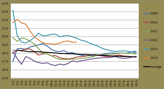
While the 20C barrier has been broken in other locations during the past 3 days, Jyväskylä hasn't hit the mark since June 11. It came close over the weekend though with tops of 19.0C and 19.5C on Saturday and Sunday. Today is the 19th consecutive day below 20C. The graph below shows the longest stretches below 20C for each summer since 2009.

Highest number of consecutive summer days below 20C in Jyväskylä for the summers of 2009-2014
(as of June 30 2014)

This current streak is more than double the longest runs of both 2009 and 2010. It's also running deep into what is normally the warmest time of the year rather than the typical time of late August. Based on forecasts for the coming days, the run should go until Saturday, a total of 23 days.

Warm temperatures were seen in Sydney late last week but they dropped yesterday. While Jyväskylä struggles to climb above 20C, Thursday to Saturday at the Airport all saw a daily maximum above the mark. It is quite unusual though. Since 2000, only 4 years have seen 3 or more consecutive days above 20C around this time of the year.

The month's warmest temperature of 23.2C was recorded on Saturday. As mentioned in a previous post, winds have been quite strong for the past week in Australia's south-east. A very strong and gusty westerly change dropped temperatures quickly in the late afternoon on Saturday. Yesterday only reached 17.4C and with a maximum of 16.6C, today was the equal second coldest day of the month.

June 25's 85km/h gust didn't hold the title for the strongest of the year for very long. The westerly change on Saturday saw a strongest recorded gust of 94km/h. December 5 last year also recorded a gust of the same strength, as did October 29 and August 12. No other gust recorded last year was higher than 94km/h.

Rain and snow has been affecting parts of Victoria and southern New South Wales for the past week, but Sydney has remained precipitation free since June 16. It should continue like this for the time being as well.

Wednesday, 25 June 2014

Rare optical phenomenon in Jyväskylä yesterday

People in Central Finland might have noticed something strange in the sky yesterday morning. A couple of odd looking rings appeared around the sun and in the surrounding sky at about 10am in Jyväskylä.

I had never personally seen this phenomenon before so I had to look it up. It is known as a halo. As this Wikipedia article describes:
They are produced by the ice crystals in the cirrostratus clouds high (5-10km) in the upper troposphere. The particular shape and orientation of the crystals is responsible for the type of halo observed. Light is reflected and refracted by the ice crystals and may split up into colours because of dispersion. The crystals behave like prisms and mirrors, refracting and reflecting sunlight between their faces, sending shafts of light in particular direction.

Halo over Jyväskylä on June 24

Halo crossover with a faint rainbow in the lower left corner

Unfortunately my camera doesn't quite do it justice, but I have to say it was an amazing sight. This video captured north of Jyväskylä shows the full halo.

Tuesday, 24 June 2014

Intense low brings strong winds and snow to Australia's south-east

There might be some people from outside of Australia wondering if they read the heading right; snow and Australia in the same sentence? People might be surprised to know that some locations in Australia can, and often do, reach a greater maximum snow depth than what most of Finland does.

An intense low pressure system currently moving across Australia's south-east is causing widespread damage throughout the region. Strong winds have been affecting areas from southern South Australia through Victoria to the southern half of New South Wales.

The system hit South Australia already late on Sunday. Yesterday morning Adelaide Airport recorded a maximum gust of 93km/h, the strongest since September 30 last year. Today the strong winds moved east and it was Melbourne and Sydney's turn.

Sydney Airport today saw a maximum recorded wind gust of 81km/h. This is the strongest gust so far this year and the strongest since December 29, almost 6 months ago. Bellambi, just north of Wollongong, saw a gust of 113km/h at 7:26pm, the strongest in more than a year.

Melbourne saw strong winds also. A gust of 104km/h was recorded at Melbourne Airport just before 1pm. The station on South Channel Island in the far south of Port Phillip recorded the strongest gust of the region at 122km/h.

Storm surges also caused minor flooding in areas along the Yarra River in Melbourne's CBD.

In addition to the gale force winds, the system has dumped plenty of snow in the Snowy Mountains, the region between Canberra and Melbourne. Almost blizzard-like conditions have seen previously bare ground covered in up to 50cm of snow at higher altitudes. After the unusually warm autumn weather, the snow is a welcome sight for ski resorts like Thredbo and Perisher. More snow is also predicted to fall in the coming days.

Several images and more information about this weather event can be found in this ABC news article.

Saturday, 21 June 2014

Cold midsummer in Finland, warmer in Sydney

The winter/summer solstice is today, but the seasons don't seem to matter too much right now for Sydney and Finland. Sydney has been far warmer than Jyväskylä despite it being winter there, and this current trend will continue for the time being.

One of the big yearly holiday events for Finland is this weekend, Juhannus, also known as midsummer. Unfortunately, the weather has been anything but summery for the past week and a half. After the 4th coldest day of the past 6 years, temperatures plummeted on Wednesday morning to -1.4C. This is the coldest in at least the last 6 years. It's hard to find exact records, but some websites indicate the lowest ever recorded June temperature in Jyväskylä is around -3C.

Unlike a day earlier, Wednesday managed to climb above 10C. It actually got to 15.1C during the day. Thursday and yesterday, however, failed to reach that mark with 14.3C and 12.7C respectively.

Today is the longest day of the year for the Northern Hemisphere.
These are the sunrise and sunset times for Jyväskylä.
Source: Finnish Meteorological Institute

Surprisingly (or then maybe it's not that surprising if you know Finland), all midsummer weekends in the past 6 years haven't been that warm. Not one day in all those weekends since 2009 has measured above 25C, the highest being 23.4C on June 25 in 2010. Based on current forecasts, the midsummer weekend this year will have the lowest average temperature.

While Jyväskylä struggles to climb above 15C, today Sydney Airport made it 3 straight days above 20C for the 4th time this month. This is quite unusual for June. It occurred twice in June last year, but not once between 2009 and 2012. Years before 2009 also show few, if any, occurrences. Yesterday's 22.3C was the second warmest maximum of the month so far. It got to 20.3C today.

The warmer temperatures have been accompanied by drier conditions also. Today was the 5th straight day without rain, the longest stretch since late May.

At this point, Sydney Airport is on track to record one of its warmest Junes on record.

Tuesday, 17 June 2014

Summer snow this morning in Jyväskylä

Scarves and gloves made their return this morning for many living in Finland. It has been a rather cold day today with temperatures hovering around only 5C for most of the day. It wasn't until after 6pm that the temperature climbed closer to 10C. While this kind of cold isn't unheard of for locations in Finland during the summer, it is quite unusual.

The cooler temperatures are the result of the combination of two low pressure systems, one situated just east of the Finnish-Russian border, the other in the Norwegian Sea, as well as a high pressure system north of Ireland. Together they are generating very cold northerly and northwesterly winds over most of the Nordic region.

In Finland's far north at Kilpisjärvi the temperature dipped to a low of -6.2C this morning. The all time record for June in Finland is only slightly lower at -7.0C, recorded back in 1962. At Jyväskylä Airport the temperature slowly declined yesterday evening from just above 10C at 9pm to just above 0C a bit before 6am today. There were sightings of snow flurries in Jyväskylä this morning, a rare event for summer here.

Snow falling in Jyväskylä's northern suburb of Palokka around 6am on June 17
Source: Liikkenne Virasto

The view slightly further north in Puuppola
Source: Liikkenne Virasto

Snow also fell in Kuokkala in Jyväskylä's south

This morning's low was the second lowest June temperature in the last 6 years. It dropped to 0.2C, quite close to the 0.0C recorded on June 8 in 2009. It was also the lowest since May 17. Today's high will probably be the coldest of the month. 2009 holds the record for the past 6 years for that statistic as well due to a 7.5C daily maximum on June 5 of that year.

Monday, 16 June 2014

How's the month of June progressing so far?

The first half of June has seen both Sydney and Jyväskylä experience a fairly warm start to the month. The warmth looks set to continue in Sydney, but a cold end to the month is on the cards for Jyväskylä.

The graph below shows the progressive average minimum for Jyväskylä in June during the past 6 years. It's quite interesting to see how the years have been split. 2009, 2010 and 2012 have clearly had lower minimums while 2011, 2013 and, so far, 2014 have been much warmer.

Progressive average minimum for June at Jyväskylä Airport in the period 2009-2014

The 6 days of June 4 to 9 saw minimums above 10C, helping the average climb 3.5C in that time. However, with the way the past week has gone, which included a low of only 1.1C yesterday (the 6th coldest June temperature of the past 6 years), and by looking at current forecasts, it's unlikely that the orange line will continue to remain in the vicinity of the lines of 2011 and 2013.

Jyväskylä started the month with a few days of maximums below 20C, but the same 6 day run mentioned above had an average top of 24.4C, causing the monthly average to climb almost 5C. It has been dropping for just over a week now though. Based on current forecasts 2014's average maximum could possibly end up the lowest of the past 6 years.

Progressive average maximum for June at Jyväskylä Airport for the period 2009-2014

In Sydney, minimums at the start of the month have been fairly similar to previous years. It wasn't until the end of last week and the continuation of minimums above 10C when 2014 pushed towards the top, now only below 2013. It's also interesting to see where the long term average lies, far below figures from the past 6 years.

Progressive average minimum for June at Sydney Airport for the period 2009-2014 plus the long term average

The average maximum for Sydney so far this June is also holding steady as one of the warmest. Including today, this month has already seen 8 days with a maximum above 20C. Only 2013 saw more since 2009 with 10. 2010 didn't have any days above 20C. 2013 still holds the edge for now as shown in the graph, but a 10 day run from June 16 last year saw an average high of only 15.5C, the coldest 10 day period throughout all of last year.

Progressive average maximum for June at Sydney Airport for the period 2009-2014 plus the long term average

Based on current predictions, it doesn't look like something similar to that will be happening this June. Forecasts for the next week show relatively warm highs between 19C and 22C.

Tuesday, 10 June 2014

Cooler weather ahead for Jyväskylä, showers continue in Sydney

The 6 days prior to today in Jyväskylä have all seen a maximum above 20C, but temperatures should drop after tomorrow. Temperatures have already been down on the 25C+ days from the end of the last working week, but comfortable highs around 21C and 22C have been around since Saturday.

Unsettled air continued to produce storms and showers throughout Finland up until today. Jyväskylä has also continued to escape mostly unscathed. Including today, the past 5 days have seen falls at the Airport but the total for that period hasn't topped 10mm.

Tomorrow should see a brief return to temperatures above 20C, but the remainder of the week will fail to reach that high. Saturday's current forecast is for a maximum of only 16C. Rain might also be around later in the week.

Fields in Sippulanniemi near Jyväskylä on June 7

Rain and wet conditions have continued in Sydney. Today made it 7 consecutive days of rain recorded. A total of 7.6mm fell throughout the day taking the monthly total to 104.4mm. This is already getting close to the long term average for June of 122.9mm.

The morning of June 9 finally saw the temperature dip below 10C for the first time this year at the Airport. It dropped to a low of 8.0C around 7am. It was also the first time below 10C since October 15 last year.

As I have mentioned earlier, 2014 has broken the record for the latest date in the year for the first minimum below 10C. Since 1939, there has been no other year that you have to go as deep as June to find the first minimum below 10C. The previous record was May 29 in 2003.

As for Observatory Hill, it also dropped below 10C yesterday for the first time this year. Temperature records there date back to 1859. 2014 ended up equalling the previous record of June 9 from 1988. Every other year since 1859 had a date before the month of June.

These records stand in line with figures that suggest daily minimums are continuing to climb in Sydney.