Warm evening temperatures in Sydney yesterday continued until around 1am this morning. It was 24.9C at midnight at the Airport before the city was hit by a strong southerly change. The strongest winds for the day were between 2am and 5:30am, with the highest gust being 70km/h right on 5am.
The rest of the day was rather cool. Southerly winds continued throughout the day and showers affected most locations around Sydney. The Airport received 4.2mm between 10am and 2:30pm. The winds and showers dropped temperatures further during the day. At 1:23pm it was sitting at only 15.6C.
Just like Sydney, if it weren't for warmer temperatures just after midnight in Jyväskylä the daily maximum would be much lower. It sat just below zero before dropping below -5C by 6am. It's almost 3pm now and the temperature hasn't risen above that mark, with no signs of it doing so until tomorrow afternoon. The current daily minimum is -7.4C, although it might get colder this evening.
During yesterday afternoon and evening there were some strong winds and flurries of snow. After sitting a couple of degrees above zero, winds turned from westerly to northwesterly around 3pm dropping temperatures to minus. The strongest wind gust I noticed at Jyväskylä Airport was 17m/s (61km/h) at 8:40pm, not too far from storm force.
I went for a run around Jyväsjärvi yesterday around 4:30pm and for anyone who knows Jyväskylä, going across Kuokkala Bridge against strong winds while wet snow is falling is anything but nice. I've only gone across the bridge in conditions that bad two or three times before. The slippery ice didn't help either...
Friday, 29 November 2013
Wednesday, 27 November 2013
Jyväskylä back to plus temperatures, Sydney 'cool' period continues
It's wet and cloudy again in Jyväskylä. A period spanning around 36 hours saw temperatures hold well below zero until a slow increase back to above freezing yesterday evening. It's currently sitting around 3.0C with the forecast predicting it to rise to 4C this evening.
Monday evening saw the mercury drop to -8.9C, but -13.3C around 9am yesterday was the coldest point in the 36 hour period. This is easily the lowest minimum of the month so far. In terms of the month of November, since 2008 only 2010 has seen lower temperatures; 5 days towards the end of November 2010 were -15C or lower.
There is still a fair amount of snow in Jyväskylä, but that will only decrease in the next 30 hours with forecasts showing plus temperatures for that whole period.
Sydney's 'cool' November continued with the average minimum not being improved in the last 2 days. Minimums of 15.8C yesterday and a cool 14.2C today actually dropped the average minimum further. Yesterday also had the lowest maximum in just over a week, only rising to 21.1C. It was slightly warmer today getting to 24.1C.
In addition to the low average minimum, the average maximum for the month has also taken a hit. After the first two weeks of November it stood at 26.1C. It has dropped to 24.7C since then. With summer drawing closer you would think it would work opposite to that.
Winds turned northerly this evening in Sydney though and temperatures are predicted to reach 30C tomorrow. Friday and Saturday's forecast maximums of 23C and 21C won't help increase the average though. If temperatures are as predicted then the average for the last three days would be 24.7C, coincidentally the current average maximum.
Monday, 25 November 2013
Cool in Jyväskylä, mild in Sydney
The approaching winter in Jyväskylä has been better felt in the last few days. Despite temperatures rising to 2.5C on Friday after Thursday's snow, it has been cooler since then. I was in Helsinki since Thursday evening, but based on my observations after coming back to Jyväskylä yesterday it was rather wet here on Friday. There is a small layer of ice making walking in the centre of town a challenge. A fresh sprinkling of snow in the early hours of Sunday have turned the city white though.
Beautiful clear skies arrived yesterday morning and have led to lower temperatures. Temperatures for the whole day yesterday stayed below zero. This was the first day in 8 months that that had happened. The daily minimum of -7.6C was also the coldest temperature since April 11. Forecasts currently predict -8C overnight, but I wouldn't be surprised to see temperatures briefly drop below -10C.
The average maximum for November in Sydney continues to be lower than both September and October with less than a week remaining. Since Thursday the daily maximums in Sydney have slowly been decreasing. The average maximum is currently 24.8C after it reached only 22.0C today. This is still above the long term average of 24.0C though, further highlighting how warm September and October actually were.
The highest monthly minimum set last Thursday was short-lived with the temperature on Friday dropping only as far as 20.1C. As the end of the month draws near the average minimum is still the lowest in the period since 2009.
Southerly winds were strong this evening, reaching a maximum gust of 78km/h after 5:30pm. This matches the highest gust for the month which was recorded on Friday. A bit more than 10mm of rain also fell in the few days since my last post on Thursday, pushing the monthly total to 171.4mm. At least another 0.4mm is to be added from the current 24 hours to 9am period also.
Beautiful clear skies arrived yesterday morning and have led to lower temperatures. Temperatures for the whole day yesterday stayed below zero. This was the first day in 8 months that that had happened. The daily minimum of -7.6C was also the coldest temperature since April 11. Forecasts currently predict -8C overnight, but I wouldn't be surprised to see temperatures briefly drop below -10C.
 |
| Sun setting over Jyväsjärvi |
 |
| Ice is starting to appear in Jyväsjärvi |
 |
| The sun shining on buildings in Jyväskylä Centre and Lutakko |
The average maximum for November in Sydney continues to be lower than both September and October with less than a week remaining. Since Thursday the daily maximums in Sydney have slowly been decreasing. The average maximum is currently 24.8C after it reached only 22.0C today. This is still above the long term average of 24.0C though, further highlighting how warm September and October actually were.
The highest monthly minimum set last Thursday was short-lived with the temperature on Friday dropping only as far as 20.1C. As the end of the month draws near the average minimum is still the lowest in the period since 2009.
Southerly winds were strong this evening, reaching a maximum gust of 78km/h after 5:30pm. This matches the highest gust for the month which was recorded on Friday. A bit more than 10mm of rain also fell in the few days since my last post on Thursday, pushing the monthly total to 171.4mm. At least another 0.4mm is to be added from the current 24 hours to 9am period also.
Thursday, 21 November 2013
Snow for Jyväskylä, unsettled in Sydney
Snow has arrived in Jyväskylä. It began falling around midday and there is a few centimetres of ground cover after a bit more than 4 hours. Temperatures overnight were the coldest in a month dropping to -5.6C before midnight and to -5.7C just after.
It should slowly warm to 3C by tomorrow though so there'll be plenty of slosh around the city. In addition to the above zero temperatures, rain will probably melt most of the snow that will have fallen. The 5 day forecast shows minus temperatures and sun by the end of the weekend.
Sydney was warm again today reaching a top of 27.1C at the Airport. The daily minimum was the warmest of the month at 19.6C. This was the highest in almost a month.
Storms affected many parts of NSW this evening. Sydney was mostly spared but Canberra, for example, experienced a short but severe storm. Two separate wind gusts of 93km/h were recorded at 6:41pm and 6:46pm. This was after a gust recording of 19km/h less than 5 minutes earlier at 6:37pm. Rain was heavy also with 25mm recorded in just over 10 minutes at Canberra Airport.
Storms crossed the Blue Mountains west of Sydney around 8pm but weakened as they approached the coast. The Airport received 1.2mm around 9pm. More storm activity is forecast for tomorrow.
Wednesday, 20 November 2013
Calmer weather after a wild few days
Sydney and Jyväskylä returned to fairly normal weather yesterday and today after a wild weekend in both locations. Over the weekend and continuing on Monday, winds from the storm known as 'Eino' howled in Jyväskylä and other parts of Finland, while heavy rain continued in Sydney.
On Monday the northern Sydney suburb of Hornsby experienced a small tornado. Roofing from a local shopping centre was torn off, branches were ripped from trees and a small portable office building was blown over as powerful localised gusts associated with the tornado moved through the area.
Rain over the 5 day period totalled 119.6mm at Sydney Airport pushing the monthly total so far to 158.8mm. Observatory Hill recorded 92.8mm pushing its total to 171.6mm. Temperatures were cool over the weekend also. Sunday was the lowest maximum for the month so far at 18.2C. It only reached 18.8C on Monday also. Yesterday and today were much nicer with temperatures reaching 24.1C and 26.7C.
That familiar autumn rain and cloud arrived back in Jyväskylä early yesterday morning. Mist and rain fell continuously over a period of 27hrs, but it was fairly light with only 9.1mm being recorded throughout that time. Today has been much clearer though.
Temperatures were above zero again. It actually pushed above 5C yesterday evening and held there until just after midnight. Including today, that makes a run of 6 consecutive calendar days with the maximum above 5C. This is the latest time in the year for that to occur in the 2008 to 2013 period. The warm November of 2011 was responsible for the previous record, with 6 consecutive days above 5C up to and including November 8. Other years experienced this final occurrence in October.
Snow is forecast to fall tomorrow afternoon as temperatures drop leading in to the weekend.
Sunday, 17 November 2013
3rd strongest storm for Finland since 2000
Finland experienced its 3rd strongest storm since 2000 today. An intense low pressure system that was originally off the north-western coast of Norway a couple of days ago moved over the northern half of Finland during the day.
The most destructive part of the storm were the strong westerly and northwesterly winds which were felt throughout most of the country. The strongest gust of the day was recorded in Rantasalmi, located in the central eastern part of the country between the towns of Varkaus and Savonlinna. The gust was measured at 29.2m/s (about 105km/h) this afternoon. The most unusual thing about this is the fact that Rantasalmi is not near the coast. While Rantasalmi is situated nearby a large lake, this goes to show that many inland locations throughout Finland, not just coastal areas, were affected by the strong winds.
In the south, gusts at Helsinki-Vantaa airport were above 25m/s also. In Jyväskylä strong winds were felt during the morning and into the early hours of the afternoon. I tried to monitor wind gusts as they were updated each 10min but there appeared to be a power outage at the station around 11am. Before that point the strongest gust I saw was 19m/s (about 68km/h). There were power outages throughout the country, with an estimated 100,000 properties without electricity at some point during the day.
I have to say I personally didn't notice the storm developing. I'm pretty sure the first forecasts predicting the storm were made only a couple of days ago, which in a way is rather late considering the force of the storm as experienced today. Warnings issued by the Finnish Meteorological Institute were in place yesterday evening though as the potential effects of the storm were realised.
As for temperatures and rainfall, precipitation fell in areas north of Jyväskylä while temperatures mostly remained above zero. In Jyväskylä there was a brief shower and flurry of snow just before midday. There were no significant falls though. In fact, the station at the airport didn't even record trace amounts. Temperatures in Jyväskylä were above 4C this morning before dropping to around 2C this afternoon.
I took a few photos this morning when the winds were at their peak. My images unfortunately don't show some of the more serious damage that took place, including fallen trees and damaged buildings, but this is a small glimpse of what Jyväskylä was like today.
 |
| A fallen branch in Mäki-Matti |
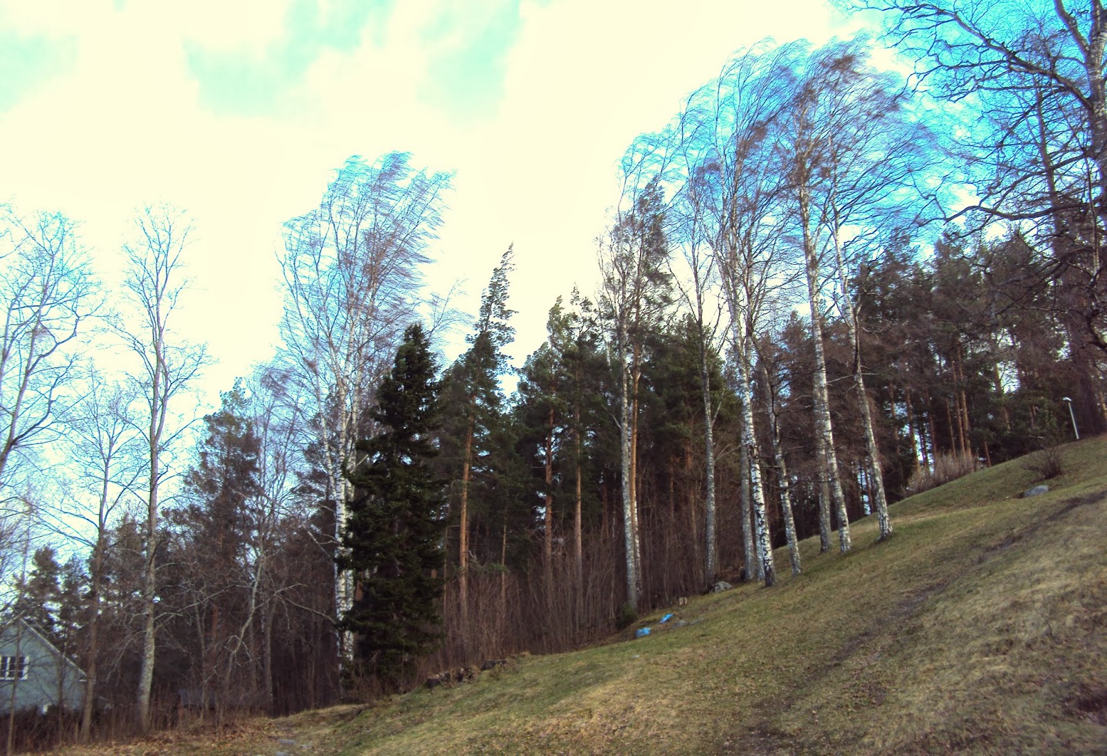 |
| Trees bending over from the force of the wind |
 |
| A piece of what appeared to be roofing which had been torn off blew around close to cars in the city centre |
Friday, 15 November 2013
Heavy rain and storms in Sydney right now
Heavy rain and storm activity has been affecting different parts of Sydney for the last few hours. The Northern Beaches and suburbs further north on the Central Coast have seen strong falls with well over 50mm in only a couple of hours.
Sydney Airport and surrounds have also received big falls. From 10pm to midnight 58.2mm fell. If we look at long term averages for November at Sydney Airport, we can see that the average monthly rainfall is only 81.2mm. So more than 70% of the average monthly rainfall fell in just 2 hours!
Currently the rainfall total in the 4 hours from 9:45pm to 1:45am stands at 75.0mm with rain still falling. These falls have been rather isolated though as Observatory Hill, not more than 10km to the north, has received a much lower total of 21.2mm since 3pm. On the other hand, from the Rainfall since 9am view of the Sydney rain radar on the BoM site, it looks like Sylvania and surrounding suburbs in Sydney's south have received over 80mm.
Most of the rain is now off the coast of Sydney and is moving out to sea. The forecast for Saturday predicts further falls though with the chance of storms.
Subscribe to:
Posts (Atom)