Monday, 20 April 2015

Cyclone-like conditions in Sydney at the moment

A low pressure system right off the coast of Central New South Wales brought cyclone-like conditions to Sydney today. Forecasts yesterday predicted an increase in rainfall during the evening, but it wasn't until today that the full effects of the system arrived.

Wind gusts did strengthen yesterday and held steady around 60km/h for most of the evening as the low moved slowly east, but the only rainfall that fell was in the early hours of the morning. A measly 0.8mm was added to the monthly total, which stood at 46.6mm by midnight yesterday.

Today, however has more than doubled that figure. Rain in the form of showers arrived a bit after 5:30am this morning, initially moving in a southwesterly direction, and it has been almost unrelenting since then as the system developed into a larger, more dense area of rain. Sydney Airport has seen 73.0mm. This is easily the highest daily total of the year so far, surpassing January 27's 35.0mm. It also the highest total in six months; the previous higher total being 86.0mm on October 14 last year.

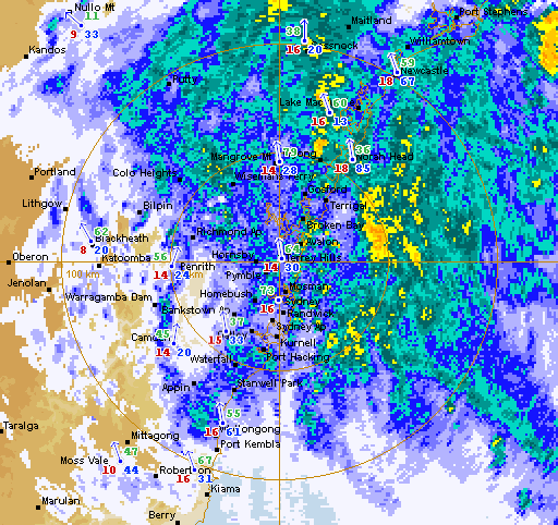
Sydney is somewhere in there! The Terrey Hills 128 km rain radar image at 6:30pm AEST on April 20
Source: Bureau of Meteorology (screenshot unedited from original image)
These two radar images really tell the story. Something else to note from these images are the coloured numbers. For each respective weather station shown on the map, the red numbers indicate the temperature (at 6:30pm and, below, at 10pm), blue indicates average wind speed (in km/h) and green represents the rainfall total in the hours from 9am.

Not much better. The Terrey Hills radar at 10pm
Source: Bureau of Meteorology (screenshot unedited from original image)
By late afternoon, rain was coming from directly off the coast, but the whole system itself was gradually moving north. At the time of the second radar image above at 10pm, the rain area stretched from just south of Kiama all the way to the Mid North Coast town of Forster, a distance of around 350km.

Wind gusts reached 70km/h yesterday at Sydney Airport, the strongest in just over four weeks. Wind speeds were around 55km/h until the late morning. By late afternoon they had increased above 70km/h. The strongest gust of today was 91km/h, not too long before midnight. That was surpassed at 12:05am on April 21 with a recording of 93km/h.

It wasn't only strong winds and rain that were felt in Sydney. Temperatures were also down. It reached a top of only 17.2C at the Airport. Coincidentally, this is the coldest maximum since October 15. Today also saw the coldest maximum for an April day at the Airport since 2009. Of the years since 2009, this is also the earliest date for such a low maximum. Maximums this low aren't typically seen for another couple of weeks. The daily minimum was the lowest seen since early November too. It dropped to 13.9C.

Sydney is in store for more of the same during the early hours of April 21 and rain and strong winds could continue until later in the day. More information to come...

Friday, 17 April 2015

Mid-month progress of April 2015 averages

April 2015 has seen a warm first half of the month in Jyväskylä. The 16 days so far don't give averages quite as high as the respective numbers from 2010, but they do sit in second and third place for the average minimum and maximum out of the years since 2009.

One thing that is clear for Jyväskylä is the lack of cold minimums. So far there has been only one minimum below -5C, and it's very possible that there won't be any more. 2010 hadn't seen any minimums below -5C by the 16th and 2011 had seen one also. On the other hand, 2013 saw 13 of the first 16 days go below the mark.

A new part of my progressive graphs show predicted values for the coming days. Current forecasts show the average minimum holding steady just below zero, possibly ending up in a similar position as the averages from 2010 and 2011.

Progressive average minimum for April at Jyväskylä Airport for the period 2009-2015

Daily maximums at the start of April in the years since 2009 have varied quite a bit as well. 2010 saw a very warm beginning with April 1 and 2 topping 10C. 2012 saw maximums remain below zero until the 4th.

2015 sat among the remaining years for the first few days, but it quickly climbed towards 2010's figures thanks to April 11 and 12 topping 10C; the latter reaching a remarkable 14.9C. Cooler temperatures this week have stabilised the average, and forecasts predict it to stay at a similar level, increasing only slightly in the next 10 days.

Progressive average maximum for April at Jyväskylä Airport for the period 2009-2015

Sydney has seen an interesting start to April. The average minimum sits well above the long term figure, but it is somewhat average when compared to the previous six years. The daily figures haven't been especially high. Only two minimums so far topped 18C, compared to six in 2009 at the same date, and five in 2014. However, the lowest temperature seen after 17 days is 14.5C. All other years had seen a minimum lower than this by April 17.

The forecast shows some warm minimums in the coming couple of days, but they will drop next week. The overall average for the month is likely to sit somewhere close to the majority of figures from recent years.

Progressive average minimum for April at Sydney Airport for the period 2009-2015 plus the long term average

Tops of 29.3C and 31.0C, the latter of which, at the time, was the highest April temperature at Sydney Airport since 2006, got the month off to a warm start, but maximums dropped quickly after. There was a run of 12 straight days below 25C. April 15 and 16 followed with warm temperatures once again. The 16th's 32.6C maximum replaced the 2nd as the warmest since 2006.

The average dipped to the lowest respective figure on April 13, but the 32.6C maximum quickly pushed it back above the long term progressive average. The coming week will see a drop in the average, but that's only normal for this time of the year.

Progressive average maximum for April at Sydney Airport for the period 2009-2015 plus the long term average

Tuesday, 14 April 2015

Cool April period in Sydney, warm weekend in Jyväskylä

The jump to autumn has been a bit sudden in Sydney this month. The end of March saw fairly warm temperatures above 25C, and the first two days of April were also rather warm, but of the 12 days since then, only one has surpassed the 25C mark.

April 2's top of 31.0C at Sydney Airport was the highest April temperature seen since 2006. The temperature drop was sharp though with April 3 only getting as high as 20.5C as rain also arrived across Sydney.

Today reached a top of 23.3C, the highest in a week. The current run of eight consecutive days below 25C is the longest since the middle of September last year, but while the drop has been a little quick after a warm, but not excessively hot, March, these temperatures aren't unusual for April.

Minimums have been quite steady as well. The past 10 days have seen figures ranging only 1.3C between 14.5C and 15.8C. The 14.5C was seen this morning and is the third lowest so far this year.


Early spring in the northern Finnish city of Oulu on April 12

It was real spring weather in Jyväskylä over the past weekend. Saturday saw it climb to 10.6C at Tikkakoski, the third warmest temperature of the year, but it was quickly relegated to the fourth warmest on Sunday as temperatures climbed agonisingly close to breaking the 15C barrier. After an overnight low of -2.6C, it 'soared' to 14.9C, the warmest in almost seven months.

The 14.9C figure for April 12 is easily the earliest time of the year for such a temperature in the years since 2009. 2010, 2012 and 2013 didn't see a maximum that high until May. Of the previous six Aprils, 2014 saw the earliest date above 14.9C with 17.1C recorded on the 21st day of the month.

Temperatures dropped on Sunday evening though as a low pressure system arrived over southern Finland. Showers, and even a small amount of storm activity, worked their way north, dropping temperatures along the way. Yesterday still reached 8.0C at Jyväskylä Airport, but today has been cooler still, getting to only around 5C.

April has been quite dry in Jyväskylä so far. Today is the sixth day of precipitation at Tikkakoski, but the total so far sits at only 5.3mm. Half of that has fallen yesterday and today. The forecast for the coming week does show some more signs of rain, but it doesn't look like there'll be any especially heavy falls.

Monday, 13 April 2015

Post 200

This post is number 200 for WeatherBout. I consider this blog as a hobby and I've enjoyed being able to convert my own recorded statistics, along with historical records for Sydney and Jyväskylä, into more easily consumable information.

So instead of text, I thought this post could simply have a collection of some of my favourite images from those I have shared in the past, plus one new image. Enjoy!

Isolated showers roll east over Sydney's Kurnell, with Bare Island in the foreground, on September 21 in 2013

Menacing clouds as part of an afternoon southerly change over the suburb of Botany on October 13. The 13th saw a top of 36.2C at Sydney Airport. The following day only climbed to 17.7C

Unusual ice coverage on Jyväskylä's Jyväsjärvi on March 1 in 2014. The 2013/14 winter saw very little snow in Jyväskylä, but a cold January helped to thicken lake ice

Evening sunset over Jyväskylä's Tuomiojärvi on March 26

June 1 in 2014 didn't see temperatures quite as warm as what was seen in the middle of May, but summer had well and truly arrived, as can be seen in this picture taken at Äijälänsalmi

The heat did return for a couple of days at the beginning of June, but storm activity was part of a change that led to unusually cold temperatures at the end of the month. This was the view over Jyväskylä on June 7

The sun peeks out from behind the clouds on July 28

September saw a very warm start to the month, but autumn was always coming. These colours were seen in Jyväskylä's Mäki-Matti on September 29

November 1 was one of only two days during the month that saw sun in Jyväskylä. Overnight temperatures down to -9.5C led to frost across the region

December 29 in 2014 was the second coldest day of the month. Most of the day saw temperatures hover around -15C. This was the view near Taulumäki a bit after 2pm

Tuesday, 7 April 2015

March 2015 Review - Jyväskylä

Above average figures from February in Finland weren't limited to that month only as they carried over into March in 2015. Just like the month prior, Jyväskylä recorded the fifth warmest March since at least 1961. All of Finland saw above average temperatures. Precipitation was above average for most of the country as well.

The past two Marches in Jyväskylä have been comfortably above long term figures. Their difference to the years between 2009 and 2013 can be seen below.

March averages at Jyväskylä Airport for the period 2009-2015

Since 2009, 2015's figures are only surpassed by those from 2014. The Finnish Meteorological Institute recorded an overall monthly average of -0.4C. This puts March 2015 as the fifth warmest since at least 1961. 2007 recorded the warmest, but as with February as well, 2014 is second on the list.

Averages throughout Finland were between 3C and 5.5C above the average. The greatest differences were seen in the northern half of the country. Some parts of Lapland saw warmth that is, on average, experienced only once every 50 years.

Three out of the four extremes in Jyväskylä for March were the highest respective figures since 2009. The coldest temperature was -15.7C, recorded on the 26th. Marches from 2010 through 2013 all saw temperatures below -20C. The coldest day was March 21. It climbed as high as -3.1C then, just above 2014's figure of -3.2C.

The highest daily minimum was also the highest figure since 2009. The 8th saw very mild overnight temperatures. It never went below 2.7C then. Only the overall maximum for the month wasn't the highest respective figure of the past seven years. It was, however, the second highest. Both March 17 and 18 topped 11.2C. 2014 saw a top of 12.1C, but it only saw two days above 10C, while 2015 saw three. Of the five Marches prior to 2014, the highest temperature seen was 7.2C in 2011.

Country extremes ranged from 13.5C in Jomala on the 8th down to -28.1C in Salla on the 22nd.

The start of the month continued the mild weather seen in late February. March 12 saw a change as overnight temperatures plummeted and daytime temperatures soared. The week between the 12th and 18th saw each day record a difference between the minimum and maximum of more than 15C. The last time there were more consecutive days than seven with a temperature difference greater than 15C was in February 2011. The difference on both March 16 and 17 was 20.9C. This was the highest daily difference since May 19 last year.

The graph below shows the unusual weather in the middle of the month. It was also very dry during that period.

Daily minimums and maximums against rainfall at Jyväskylä Airport for March 2015

Precipitation during the month fell as snow and rain. Only a few small areas in the far north, south-east and between Tampere and Lahti experienced below average totals. A total of 46.3mm was recorded at Tikkakoski. FMI recorded the total as 46mm. This is compared to 2014's figure of 29.8mm and the 1981-2010 average of 36mm.

There were 18 days of precipitation. 10 of those made up the longest precipitation streak which lasted from March 2 to 11 and accounted for 21.0mm. The following 10 days saw the opposite with no rain or snow recorded. The wettest day was the 30th of the month when 7.1mm was measured. It was one of three days to exceed 5mm.

Snow depths were above 30cm at the start of the month but quickly dropped as the temperatures exceeded 6C on the 12th. By the 15th the depth sat at 23cm, about half the long term average, but by the end of the month it wasn't much different, sitting at about 20cm.

March 2015 Review - Sydney

March 2015 in Sydney saw comfortably above average temperatures, although minimum values were slightly down on figures from recent years. It was very warm throughout the whole month and included the second highest lowest daily maximum for March on record. Most of the month was dry and the rainfall total was well below the long term average.

Averages during the past seven Marches can be seen below against the long term figures.

March averages at Sydney Airport for the period 2009-2015 plus the long term average

According to the Bureau of Meteorology, the average maximum of 26.8C sits in the top 10% of historical figures for Sydney Airport. Only one of the past 10 Marches, 2012, has actually been below the long term average of 25.3C. Despite being above the long term average, the average minimum for March in 2015 was a little lower than what has been seen recently. It was the second lowest since 2009.

The highest temperature of the month, and so far this year, was 37.9C. It was seen on March 1. It is the highest March temperature seen at Sydney Airport since 40.3C was recorded on March 9 in 2004. It is also one of only four days above 35C so far in 2015 and it was the hottest temperature seen since last November.

The warmest minimum was shared by March 4 and 10. It remained at 21.4C or higher on both days. It was the third lowest such figure since 2009, although all seven years have figures between 21.0C and 22.8C.

The coldest day was March 13. It reached a top of only 22.7C then. This is the second highest such March figure on record. Only March in 1981 saw a warmer coldest day of 23.0C. The coldest overall temperature of the month came on the 27th when it dipped to 14.0C. It is still only one of four days to see the mercury drop below 15C at the Airport so far in 2015. It was the third lowest respective March figure since 2009.

As is typical at this time of the year, temperatures declined a little as the month wore on. The graph below shows daily minimums and maximums against daily rainfall totals.

Daily minimums and maximums against daily rainfall at Sydney Airport for March 2015

Rainfall at Sydney Airport was quite a fair way below the average. Calendar day rain figures totalled 71.0mm. 30.0mm of that fell on the last two days of March. Bureau of Meteorology methods didn't include March 31st rainfall and led to a monthly total of 51.4mm, a long way below the long term average of 115.3mm. March 2014 saw 151.4mm. 2014 is one of only four of the past 20 Marches to have seen a monthly total above 85mm and above the average.

The last day of the month saw the highest daily total with 19.8mm. It is the third highest total so far this year. It was one of 12 days of rain at the Airport during the month and it was also part of one of the three three day rain streaks. The longest dry streak was from the 2nd until the 12th, a total of 11 days. This remains as the longest such streak in 2015.

Wind gusts were up on last year's figures. The high temperatures on March 1 declined quickly in the middle of the afternoon as a southerly change brought strong winds and storm activity. A south-southwesterly gust at 96km/h was recorded at the Airport at 2:34pm. Since the start of 2013 there have been only two maximum daily gusts stronger than that.

The calmest day was March 28 when a strongest gust of only 33km/h was recorded. This was above the respective figures from both 2013 and 2014 though.

Saturday, 4 April 2015

February 2015 Review - Jyväskylä

After Finland saw mild and warm February weather in 2013 and 2014, 2015 followed suit. Almost the whole 2014/15 winter has passed by in consistently above average fashion and February was no different. The Finnish Meteorological Institute ranked February 2015 as the fifth warmest in Finland since at least 1961. While temperatures were above zero more than below, snow depths were quite close to the long term average as precipitation for the month was almost smack bang on the 1981-2010 figure.

The clear difference in February averages at Jyväskylä Airport since 2009 can be seen below.

February averages at Jyväskylä Airport for the period 2009-2015

The 0.5C average maximum was the highest in the years since 2009, continuing an upward trend seen since 2011. Only 2014 saw a lower average minimum.

FMI recorded an overall average of -2.1C for Jyväskylä (compared to my -2.4C). This is a long way above the -8.5C average. 1990 holds the record for the warmest February since at least 1961, and 2014 is second behind that. February 2015 slots in as the fifth warmest February out of the past 56.

It wasn't only Jyväskylä that saw above average temperatures. In fact, the whole country did. Some areas, especially around Oulu, Kemi and Iisalmi, saw a figure more than 7C higher than their respective 1981-2010 averages. The lowest differences in Finland, in Northern Lapland and the Åland Islands in the south west, were still between 4C and 4.5C higher than average.

Jyväskylä's warmest day, February 11, saw a remarkable figure of 7.8C recorded. This was the second highest February temperature ever seen at Jyväskylä Airport. It was also the earliest date in a year for such a temperature. Temperatures dropped quickly after the 11th though, and a few days later on the 15th, the lowest maximum of the month was seen. It was only as warm as -6.5C then, but this figure was the highest in the years since 2009. The past three Februaries have all seen a respective figure higher than -10C.

The extremes for minimums included a highest minimum of 1.3C on the 20th. This is only surpassed by 2014's 3.1C. All other years since 2009 saw figures below zero. The lowest temperature of the month was -21.7C. Somewhat surprisingly, this is lower than the coldest temperatures seen in both 2013 and 2014. It was still a fair way off the numbers from 2010, 2011 and 2012 though, which were lower than -28C.

The Naruska station in Salla saw the lowest recorded temperature throughout Finland for the month. It dropped to -34.1C on the 15th. The 15th was one of four days that saw temperatures below -30C in Finland. February 2011 saw 11 minimums below -30C in Jyväskylä alone. There were also three in 2012. February 10 saw the highest overall temperature of the month. It reached 9.6C in Kaarina then.

Daily minimums and maximums against rainfall at Jyväskylä Airport for February 2015

Precipitation across Finland for February varied quite a bit. It was quite dry in Lapland as well along the west coast, but the far north west, central east and south east topped 100% of the average. In Jyväskylä, precipitation was almost right on the average of 32mm. I recorded a total of 33.3mm at the Airport, while FMI recorded 31mm. This was above last year's figure of 25mm.

Precipitation fell mostly as snow, but there were hints of rain towards the end of the month. The 22nd day of the month saw 9.7mm recorded. The 24th was the next highest with 7.8mm. They were two of only three days that topped 5mm despite there being 19 days of precipitation. A streak of 13 precipitation days carried over from late January until February 4. Otherwise the longest streak was nine, from the 17th to 25th. There were two three day periods of dry weather; February 10 to 12 and 26 to 28.

Snow levels were above average at the start of the month, but dipped below halfway through as temperatures climbed well above zero. The depth at February 15 sat at 37cm, 5cm below the long term average, but snow was still well above 2014's figure of 12cm though.