Tuesday, 14 April 2015

Cool April period in Sydney, warm weekend in Jyväskylä

The jump to autumn has been a bit sudden in Sydney this month. The end of March saw fairly warm temperatures above 25C, and the first two days of April were also rather warm, but of the 12 days since then, only one has surpassed the 25C mark.

April 2's top of 31.0C at Sydney Airport was the highest April temperature seen since 2006. The temperature drop was sharp though with April 3 only getting as high as 20.5C as rain also arrived across Sydney.

Today reached a top of 23.3C, the highest in a week. The current run of eight consecutive days below 25C is the longest since the middle of September last year, but while the drop has been a little quick after a warm, but not excessively hot, March, these temperatures aren't unusual for April.

Minimums have been quite steady as well. The past 10 days have seen figures ranging only 1.3C between 14.5C and 15.8C. The 14.5C was seen this morning and is the third lowest so far this year.


Early spring in the northern Finnish city of Oulu on April 12

It was real spring weather in Jyväskylä over the past weekend. Saturday saw it climb to 10.6C at Tikkakoski, the third warmest temperature of the year, but it was quickly relegated to the fourth warmest on Sunday as temperatures climbed agonisingly close to breaking the 15C barrier. After an overnight low of -2.6C, it 'soared' to 14.9C, the warmest in almost seven months.

The 14.9C figure for April 12 is easily the earliest time of the year for such a temperature in the years since 2009. 2010, 2012 and 2013 didn't see a maximum that high until May. Of the previous six Aprils, 2014 saw the earliest date above 14.9C with 17.1C recorded on the 21st day of the month.

Temperatures dropped on Sunday evening though as a low pressure system arrived over southern Finland. Showers, and even a small amount of storm activity, worked their way north, dropping temperatures along the way. Yesterday still reached 8.0C at Jyväskylä Airport, but today has been cooler still, getting to only around 5C.

April has been quite dry in Jyväskylä so far. Today is the sixth day of precipitation at Tikkakoski, but the total so far sits at only 5.3mm. Half of that has fallen yesterday and today. The forecast for the coming week does show some more signs of rain, but it doesn't look like there'll be any especially heavy falls.

Monday, 13 April 2015

Post 200

This post is number 200 for WeatherBout. I consider this blog as a hobby and I've enjoyed being able to convert my own recorded statistics, along with historical records for Sydney and Jyväskylä, into more easily consumable information.

So instead of text, I thought this post could simply have a collection of some of my favourite images from those I have shared in the past, plus one new image. Enjoy!

Isolated showers roll east over Sydney's Kurnell, with Bare Island in the foreground, on September 21 in 2013

Menacing clouds as part of an afternoon southerly change over the suburb of Botany on October 13. The 13th saw a top of 36.2C at Sydney Airport. The following day only climbed to 17.7C

Unusual ice coverage on Jyväskylä's Jyväsjärvi on March 1 in 2014. The 2013/14 winter saw very little snow in Jyväskylä, but a cold January helped to thicken lake ice

Evening sunset over Jyväskylä's Tuomiojärvi on March 26

June 1 in 2014 didn't see temperatures quite as warm as what was seen in the middle of May, but summer had well and truly arrived, as can be seen in this picture taken at Äijälänsalmi

The heat did return for a couple of days at the beginning of June, but storm activity was part of a change that led to unusually cold temperatures at the end of the month. This was the view over Jyväskylä on June 7

The sun peeks out from behind the clouds on July 28

September saw a very warm start to the month, but autumn was always coming. These colours were seen in Jyväskylä's Mäki-Matti on September 29

November 1 was one of only two days during the month that saw sun in Jyväskylä. Overnight temperatures down to -9.5C led to frost across the region

December 29 in 2014 was the second coldest day of the month. Most of the day saw temperatures hover around -15C. This was the view near Taulumäki a bit after 2pm

Tuesday, 7 April 2015

March 2015 Review - Jyväskylä

Above average figures from February in Finland weren't limited to that month only as they carried over into March in 2015. Just like the month prior, Jyväskylä recorded the fifth warmest March since at least 1961. All of Finland saw above average temperatures. Precipitation was above average for most of the country as well.

The past two Marches in Jyväskylä have been comfortably above long term figures. Their difference to the years between 2009 and 2013 can be seen below.

March averages at Jyväskylä Airport for the period 2009-2015

Since 2009, 2015's figures are only surpassed by those from 2014. The Finnish Meteorological Institute recorded an overall monthly average of -0.4C. This puts March 2015 as the fifth warmest since at least 1961. 2007 recorded the warmest, but as with February as well, 2014 is second on the list.

Averages throughout Finland were between 3C and 5.5C above the average. The greatest differences were seen in the northern half of the country. Some parts of Lapland saw warmth that is, on average, experienced only once every 50 years.

Three out of the four extremes in Jyväskylä for March were the highest respective figures since 2009. The coldest temperature was -15.7C, recorded on the 26th. Marches from 2010 through 2013 all saw temperatures below -20C. The coldest day was March 21. It climbed as high as -3.1C then, just above 2014's figure of -3.2C.

The highest daily minimum was also the highest figure since 2009. The 8th saw very mild overnight temperatures. It never went below 2.7C then. Only the overall maximum for the month wasn't the highest respective figure of the past seven years. It was, however, the second highest. Both March 17 and 18 topped 11.2C. 2014 saw a top of 12.1C, but it only saw two days above 10C, while 2015 saw three. Of the five Marches prior to 2014, the highest temperature seen was 7.2C in 2011.

Country extremes ranged from 13.5C in Jomala on the 8th down to -28.1C in Salla on the 22nd.

The start of the month continued the mild weather seen in late February. March 12 saw a change as overnight temperatures plummeted and daytime temperatures soared. The week between the 12th and 18th saw each day record a difference between the minimum and maximum of more than 15C. The last time there were more consecutive days than seven with a temperature difference greater than 15C was in February 2011. The difference on both March 16 and 17 was 20.9C. This was the highest daily difference since May 19 last year.

The graph below shows the unusual weather in the middle of the month. It was also very dry during that period.

Daily minimums and maximums against rainfall at Jyväskylä Airport for March 2015

Precipitation during the month fell as snow and rain. Only a few small areas in the far north, south-east and between Tampere and Lahti experienced below average totals. A total of 46.3mm was recorded at Tikkakoski. FMI recorded the total as 46mm. This is compared to 2014's figure of 29.8mm and the 1981-2010 average of 36mm.

There were 18 days of precipitation. 10 of those made up the longest precipitation streak which lasted from March 2 to 11 and accounted for 21.0mm. The following 10 days saw the opposite with no rain or snow recorded. The wettest day was the 30th of the month when 7.1mm was measured. It was one of three days to exceed 5mm.

Snow depths were above 30cm at the start of the month but quickly dropped as the temperatures exceeded 6C on the 12th. By the 15th the depth sat at 23cm, about half the long term average, but by the end of the month it wasn't much different, sitting at about 20cm.

March 2015 Review - Sydney

March 2015 in Sydney saw comfortably above average temperatures, although minimum values were slightly down on figures from recent years. It was very warm throughout the whole month and included the second highest lowest daily maximum for March on record. Most of the month was dry and the rainfall total was well below the long term average.

Averages during the past seven Marches can be seen below against the long term figures.

March averages at Sydney Airport for the period 2009-2015 plus the long term average

According to the Bureau of Meteorology, the average maximum of 26.8C sits in the top 10% of historical figures for Sydney Airport. Only one of the past 10 Marches, 2012, has actually been below the long term average of 25.3C. Despite being above the long term average, the average minimum for March in 2015 was a little lower than what has been seen recently. It was the second lowest since 2009.

The highest temperature of the month, and so far this year, was 37.9C. It was seen on March 1. It is the highest March temperature seen at Sydney Airport since 40.3C was recorded on March 9 in 2004. It is also one of only four days above 35C so far in 2015 and it was the hottest temperature seen since last November.

The warmest minimum was shared by March 4 and 10. It remained at 21.4C or higher on both days. It was the third lowest such figure since 2009, although all seven years have figures between 21.0C and 22.8C.

The coldest day was March 13. It reached a top of only 22.7C then. This is the second highest such March figure on record. Only March in 1981 saw a warmer coldest day of 23.0C. The coldest overall temperature of the month came on the 27th when it dipped to 14.0C. It is still only one of four days to see the mercury drop below 15C at the Airport so far in 2015. It was the third lowest respective March figure since 2009.

As is typical at this time of the year, temperatures declined a little as the month wore on. The graph below shows daily minimums and maximums against daily rainfall totals.

Daily minimums and maximums against daily rainfall at Sydney Airport for March 2015

Rainfall at Sydney Airport was quite a fair way below the average. Calendar day rain figures totalled 71.0mm. 30.0mm of that fell on the last two days of March. Bureau of Meteorology methods didn't include March 31st rainfall and led to a monthly total of 51.4mm, a long way below the long term average of 115.3mm. March 2014 saw 151.4mm. 2014 is one of only four of the past 20 Marches to have seen a monthly total above 85mm and above the average.

The last day of the month saw the highest daily total with 19.8mm. It is the third highest total so far this year. It was one of 12 days of rain at the Airport during the month and it was also part of one of the three three day rain streaks. The longest dry streak was from the 2nd until the 12th, a total of 11 days. This remains as the longest such streak in 2015.

Wind gusts were up on last year's figures. The high temperatures on March 1 declined quickly in the middle of the afternoon as a southerly change brought strong winds and storm activity. A south-southwesterly gust at 96km/h was recorded at the Airport at 2:34pm. Since the start of 2013 there have been only two maximum daily gusts stronger than that.

The calmest day was March 28 when a strongest gust of only 33km/h was recorded. This was above the respective figures from both 2013 and 2014 though.

Saturday, 4 April 2015

February 2015 Review - Jyväskylä

After Finland saw mild and warm February weather in 2013 and 2014, 2015 followed suit. Almost the whole 2014/15 winter has passed by in consistently above average fashion and February was no different. The Finnish Meteorological Institute ranked February 2015 as the fifth warmest in Finland since at least 1961. While temperatures were above zero more than below, snow depths were quite close to the long term average as precipitation for the month was almost smack bang on the 1981-2010 figure.

The clear difference in February averages at Jyväskylä Airport since 2009 can be seen below.

February averages at Jyväskylä Airport for the period 2009-2015

The 0.5C average maximum was the highest in the years since 2009, continuing an upward trend seen since 2011. Only 2014 saw a lower average minimum.

FMI recorded an overall average of -2.1C for Jyväskylä (compared to my -2.4C). This is a long way above the -8.5C average. 1990 holds the record for the warmest February since at least 1961, and 2014 is second behind that. February 2015 slots in as the fifth warmest February out of the past 56.

It wasn't only Jyväskylä that saw above average temperatures. In fact, the whole country did. Some areas, especially around Oulu, Kemi and Iisalmi, saw a figure more than 7C higher than their respective 1981-2010 averages. The lowest differences in Finland, in Northern Lapland and the Åland Islands in the south west, were still between 4C and 4.5C higher than average.

Jyväskylä's warmest day, February 11, saw a remarkable figure of 7.8C recorded. This was the second highest February temperature ever seen at Jyväskylä Airport. It was also the earliest date in a year for such a temperature. Temperatures dropped quickly after the 11th though, and a few days later on the 15th, the lowest maximum of the month was seen. It was only as warm as -6.5C then, but this figure was the highest in the years since 2009. The past three Februaries have all seen a respective figure higher than -10C.

The extremes for minimums included a highest minimum of 1.3C on the 20th. This is only surpassed by 2014's 3.1C. All other years since 2009 saw figures below zero. The lowest temperature of the month was -21.7C. Somewhat surprisingly, this is lower than the coldest temperatures seen in both 2013 and 2014. It was still a fair way off the numbers from 2010, 2011 and 2012 though, which were lower than -28C.

The Naruska station in Salla saw the lowest recorded temperature throughout Finland for the month. It dropped to -34.1C on the 15th. The 15th was one of four days that saw temperatures below -30C in Finland. February 2011 saw 11 minimums below -30C in Jyväskylä alone. There were also three in 2012. February 10 saw the highest overall temperature of the month. It reached 9.6C in Kaarina then.

Daily minimums and maximums against rainfall at Jyväskylä Airport for February 2015

Precipitation across Finland for February varied quite a bit. It was quite dry in Lapland as well along the west coast, but the far north west, central east and south east topped 100% of the average. In Jyväskylä, precipitation was almost right on the average of 32mm. I recorded a total of 33.3mm at the Airport, while FMI recorded 31mm. This was above last year's figure of 25mm.

Precipitation fell mostly as snow, but there were hints of rain towards the end of the month. The 22nd day of the month saw 9.7mm recorded. The 24th was the next highest with 7.8mm. They were two of only three days that topped 5mm despite there being 19 days of precipitation. A streak of 13 precipitation days carried over from late January until February 4. Otherwise the longest streak was nine, from the 17th to 25th. There were two three day periods of dry weather; February 10 to 12 and 26 to 28.

Snow levels were above average at the start of the month, but dipped below halfway through as temperatures climbed well above zero. The depth at February 15 sat at 37cm, 5cm below the long term average, but snow was still well above 2014's figure of 12cm though.

Tuesday, 31 March 2015

February 2015 Review - Sydney

Despite the lack of extreme heat, 2015 saw the warmest February of the past four years at Sydney Airport. Cooler summer temperatures towards the end of January carried over into the first few days of the month, but minimums and maximums quickly rose to typical levels soon after. Like January though, the month didn't see a day exceed 35C. It was also rather dry. The monthly total at the Airport was less than half the average.

The averages at Sydney Airport for the past few Februaries can be seen below.

February averages at Sydney Airport for the period 2009-2015 plus the long term average

The average minimum of 20.6C was the equal second highest in the years since 2009. The Bureau of Meteorology recorded the same figure and according to their records, it is the eighth highest since 1940. The average maximum was also the highest of the past four years, but cooler than both 2010 and 2011 and not within the top 10% of figures on record.

The highest temperature of the month was fairly low for February's standards. It reached 33.1C on the 8th. 2013 did, however, record a lower respective figure of 31.0C. The coolest day was a part of the cool summer period extending from January. The 22.7C maximum on February 2 was, however, the equal third highest such figure on record. 

The coldest temperature was 17.6C on February 4. Only 2010 had a figure higher than that since 2009. It is actually the fifth highest such figure on record. The highest minimum came on the 18th. It never went below 22.8C then. This figure was in the middle of those for recent years.

The return to more typical summer temperatures came on February 7 when it rose above 26C for the first time in almost two weeks. The 9th also saw the first minimum above 20C since January 25th. A good run of warm overnight temperatures followed. Of the final 20 days of the month, there were only two minimums below 20C. They were only just below that mark too with figures of 19.6C and 19.5C on the 15th and 25th respectively.

Daily minimums and maximums against rainfall at Sydney Airport for February 2015

Rainfall was far below the long term average of 111.9mm. Despite there being 11 days on which precipitation was recorded at the Airport, the monthly total only reached 44.4mm. The Bureau recorded a total of 48.0mm, putting it as the lowest since 14.4mm was recorded in 2011. More tellingly though, in the 16 Februaries since 2000, 12 of them saw monthly totals exceed 50mm, and 10 exceed 100mm.

The wettest day was February 13. It saw 18.6mm recorded at the Airport. It was part of the longest rain day streak which lasted from February 12 until the 15th and accounted for 21.8mm of the monthly total. Scattered rain days led to a longest dry streak of only six just before the period aforementioned.

Wind gusts were down on figures from the previous two Februaries. February 2 saw the strongest gust of the month, a southerly at 67km/h. This is much lower than the figures of 91km/h and 76km/h from 2013 and 2014. 

The comparatively calm start to the year in January continued during February. There were nine days with a strongest gust at or above 50km/h, much lower than the 15 and 12 occurrences of the two previous years. The calmest day was the 26th when the strongest gust was only 30km/h.

Monday, 30 March 2015

Overdue catch-up on Sydney and Jyväskylä weather

Well it has been quite some time between posts on this blog. This was due to a combination of holidays and lack of motivation, but it's time for me to get back into it.

So, what has been happening with the weather in Sydney and Jyväskylä during the past six weeks? Perhaps surprisingly, the period has only seen a slight shift in weather conditions as the new seasons of winter and summer draw closer.

The change between the middle of February and now can be noticed in different ways between the cities. In Sydney, it's the figures themselves that are the difference. Daily minimums and maximums are slowing dropping, with minimums dropping at a slightly quicker rate, but in Jyväskylä, it's maybe more the melting of snow and longer days, rather than the figures themselves, which, other than a week long period earlier this month, haven't been especially different.

Sydney is first up. In order to catch up with what has been happening, let's have a look at the year so far...

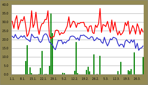
Daily minimums and maximums against rainfall at Sydney Airport for 2015 up until March 30

Since the middle of February daily maximums have comfortably held around 25C and above. A downward trend in the figures is still visible though.

The tall spike is from March 1 when the temperature reached 37.9C at the Airport. This was the hottest temperature at the Airport since the 38.0C reading from November 14 last year. In terms of March extremes, this was the highest March temperature since the 40.3C recording on March 9 in 2004. It was also the seventh highest March reading at the Airport on record. 1983 saw the record of 41.2C.

March 13 saw the lowest maximum during the last six weeks with a top of 22.7C.

The decrease in minimums is a lot clearer in the graph. Since March 12, only one minimum hit the 20C mark. The average minimum for March this year is actually on track to be one of the lowest in recent years. March 27 saw it dipped to 14.0C, the lowest of the year so far, and the second time below 15C. 2010, 2011 and 2014 didn't see a minimum below 15C until April.

Blue skies over Sydney Harbour on March 7

Rainfall totals weren't especially high during the month and a half period. Since 18.6mm fell on February 13, the highest daily total was 12.8mm a week ago on March 24. Including that and today's 10.0mm, there were four days with figures at or above 10mm. Comparing to the same point last year, the cumulative total so far this year is slightly lower; 208.0mm against 219.0mm.

March 1 was probably the highlight day since the middle of February. In addition to the heat, the end of the day saw a very gusty southerly change and storm activity around the Sydney region. A total of 10.8mm was recorded at the Airport along with a strongest gust of 96km/h. This is the third highest strongest daily gust since the start of 2013.

My three week holiday in Australia from February 19 onwards helped me to avoid some rather miserable weather in Jyväskylä.

Daily minimums and maximums against rainfall at Jyväskylä Airport for 2015 up until March 29

Most of the period while I was absent from Finland saw very little change in Jyväskylä. The 16 days from February 20 through to March 7 saw the temperature hover between a low of -1.8C and a high of 3.6C, a difference of only 5.4C.

Luckily for me, my return to the northern hemisphere on March 13 was followed by some of the nicest weather seen in Jyväskylä since last autumn. Clear skies, cold nights and warm days dominated until the 20th. Both March 17 and 18 maxed out at 11.2C. This was easily the earliest time in the year for such a temperature compared to other years since 2009. Other than last year, that kind of maximum wasn't seen until late April.

Ice of Kallavesi, north of Kuopio, on March 26

Daily maximums dipped quickly back closer to zero on the 20th. March 21's maximum of -3.1C was the coldest in over a month. Since my last post on February 17, there have only been three daily maximums below 0C. That's quite a remarkable number comparing to the six previous years. The same 40 day period in 2013 saw 29 days entirely below zero. 2009, 2010, 2011 and 2012 saw 25, 23, 20 and 14 days respectively below the mark. Even last year's warm late winter period saw eight such days.

March 22 saw the lowest temperature at Jyväskylä Airport since February 16 when it dropped to -14.5C, while the 28th's 0.5C reading was the first minimum above zero in almost three weeks.

Other than the exceptionally warm period in the middle of this month, which saw 10 consecutive rain free days, precipitation so far this year has been fairly consistent. As mentioned during the winter, snow depths have been much higher than last year, and while warmer temperatures have melted most of the snow on paths and roads, there is still some snow on grassed and in wooded areas. Snowfall in the past couple of days has also added to the icy remnants of winter's earlier precipitation.

Rain helped to melt the snow further on March 29 but it created muddy puddles in the process

In terms of coming weather, the approaching cooler period for Sydney is becoming more apparent as we head into April as lower minimums and maximums continue. Since 2009, there were only three days in total that managed to hit 30C from March 30 up until the arrival of spring.

In Jyväskylä it appears that spring is on hold, with snow and wet snow, as well as temperatures only a couple of degrees above zero, continuing for the time being. These conditions actually aren't unusual for this of the year, but recent bursts of warmer temperatures have maybe given some false hope for a quick arrival of spring.