Both Sydney and Jyväskylä saw warm weather over the weekend. It was above zero on both days in the central Finnish city, while temperatures along Australia's east coast soared well above 30C on Saturday. Cooler conditions arrived today in both cities, although Jyväskylä's drop will be longer lasting.
Sydney Airport saw its second warmest day of the month on Saturday. Only a few days after a top of 36.7C, the 35.8C maximum was the second maximum above 35C this January, and also the eighth above 30C.
Yesterday was a little cooler, but also more comfortable, as it reached 27.2C. That was despite persistent southerly winds. Weekend minimums were again above 21C, further increasing the likelihood of this January recording the highest average minimum on record.
The southerly winds had more of an impact today. The Airport saw its second lowest daily maximum of the month with a top of 23.0C. Temperatures also dipped below 20C to 19.2C in the late evening. That made today only the third day this month to drop below the mark. The early hours of January 20, however, have seen it drop to 18.4C, the first time below 19C since December 29.
Conditions remained dry at the Airport over the weekend, but a brief shower just before 3am this morning brought the first precipitation since the 14th. A total of 0.4mm was recorded. Showers are currently passing through Sydney and 3.4mm has fallen by 7am.
After rising back above zero in Jyväskylä last Thursday, mild conditions continued over the weekend. Friday evening saw it climb as high as 2.4C. It topped 2.5C just after midnight as well. The warmer temperatures made for some challenging and dangerous conditions for pedestrians and drivers as a few centimetres of packed snow turned to slippery ice.
Saturday held above zero for the whole calendar day for the first time since January 2. It finally dropped below zero at about 2pm Sunday and it has remained that way since then.
A high pressure system is now sitting on the Finnish-Swedish border and is generating colder northeasterly winds across much of Finland. As skies cleared today, temperatures dropped fairly dramatically at Jyväskylä Airport as well from just below -2C at 3am to -17.8C by 10pm. It'll get even colder overnight and the next few days will see temperatures hover close to -20C.
Light snow this morning pushed the current rain day streak to eight. 48.1mm has fallen so far this month. Sun and clear skies are expected this week though with snow possibly not returning until Friday afternoon.
Monday, 19 January 2015
Friday, 16 January 2015
Very warm first half of January for Sydney, up and down in Jyväskylä
The 2015 edition of January has seen a rather warm first half at Sydney Airport. Of the first 15 days, 13 of those surpassed 25C. The same number also remained above 20C.
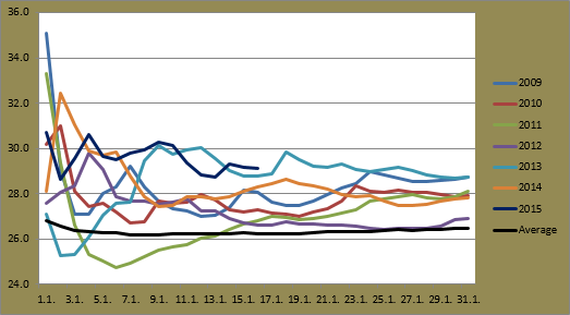
Minimums have been especially warm, as illustrated in the first graph below. While the actual daily figures themselves haven't been anywhere near record levels (2009, 2011 and 2013 recorded higher minimums than this month's highest of 23.2C so far), the consistent run above 20C has helped the average so far stay above 21C.
Bureau of Meteorology methods for recording daily temperatures differ from mine, but their current figure of 21.3C is still well above the highest overall since 1940. For the record, my measurements give an average of 21.4C so far. According to Bureau records, the highest average minimum for a January at the Airport is 20.8C, from both 1991 and 2011. Current forecasts support the idea of this January breaking the record.
While all Januaries in the years between 2009 and 2014 saw the average maximum sit below 28C at some point, this January has yet to see that happen. So far seven of the 15 maximums for the month have surpassed 30C. By the same point in the other six years, none had seen that many. 2013 was the next closest with six, while 2012 had only seen one.
Forecasts show the average holding above 28C, but they're likely to be below the figure from 2013 by the 18th. If some hotter days appear towards the end of the month, 2015 could climb to the top of the pile. 1991 also holds the record here with an average of 29.2C.
Recent fluctuating temperatures in Jyväskylä, which have included six of the 15 maximums so far above 0C, but also four at or below -10C, have led to a fairly average start for January. The overall average at this point actually sits a little warmer than the 1981-2010 figure; -7.6C compared to -8.3C.
The average minimum has seen movement above and below the -10C mark in the recent week, but it is still holding below the respective figures from 2012, 2013 and 2014. Other than the cold January of 2010, average minimums from the other years since 2009 ended up within a couple of degrees of each other.
Forecasts for the next 10 days will put 2015's line somewhere just below that of 2012. It'll come down to the final week of January before we can see the final average and where it is placed among the recent six years.
Warm maximums opened January's account this year, but temperatures quickly dropped after a few days. Based on predictions, we could see 2015 as the highest progressive average by January 17. Decreasing temperatures again next week though will force the average back down. If current forecasts for maximums at -15C and below for the end of next week come true, 2015 will place itself somewhere in the middle of the years excluding 2010.
Minimums have been especially warm, as illustrated in the first graph below. While the actual daily figures themselves haven't been anywhere near record levels (2009, 2011 and 2013 recorded higher minimums than this month's highest of 23.2C so far), the consistent run above 20C has helped the average so far stay above 21C.
Bureau of Meteorology methods for recording daily temperatures differ from mine, but their current figure of 21.3C is still well above the highest overall since 1940. For the record, my measurements give an average of 21.4C so far. According to Bureau records, the highest average minimum for a January at the Airport is 20.8C, from both 1991 and 2011. Current forecasts support the idea of this January breaking the record.
 |
| Progressive average minimum for January at Sydney Airport for the period 2009-2015 plus the long term average |
While all Januaries in the years between 2009 and 2014 saw the average maximum sit below 28C at some point, this January has yet to see that happen. So far seven of the 15 maximums for the month have surpassed 30C. By the same point in the other six years, none had seen that many. 2013 was the next closest with six, while 2012 had only seen one.
Forecasts show the average holding above 28C, but they're likely to be below the figure from 2013 by the 18th. If some hotter days appear towards the end of the month, 2015 could climb to the top of the pile. 1991 also holds the record here with an average of 29.2C.
 |
| Progressive average maximum for January at Sydney Airport for the period 2009-2015 plus the long term average |
Recent fluctuating temperatures in Jyväskylä, which have included six of the 15 maximums so far above 0C, but also four at or below -10C, have led to a fairly average start for January. The overall average at this point actually sits a little warmer than the 1981-2010 figure; -7.6C compared to -8.3C.
The average minimum has seen movement above and below the -10C mark in the recent week, but it is still holding below the respective figures from 2012, 2013 and 2014. Other than the cold January of 2010, average minimums from the other years since 2009 ended up within a couple of degrees of each other.
Forecasts for the next 10 days will put 2015's line somewhere just below that of 2012. It'll come down to the final week of January before we can see the final average and where it is placed among the recent six years.
 |
| Progressive average minimum for January at Jyväskylä Airport for the period 2009-2015 |
Warm maximums opened January's account this year, but temperatures quickly dropped after a few days. Based on predictions, we could see 2015 as the highest progressive average by January 17. Decreasing temperatures again next week though will force the average back down. If current forecasts for maximums at -15C and below for the end of next week come true, 2015 will place itself somewhere in the middle of the years excluding 2010.
 |
| Progressive average maximum for January at Jyväskylä Airport for the period 2009-2015 |
Wednesday, 14 January 2015
Warmer weather returns
Sydney saw a return to warmer temperatures yesterday. After rain in the early hours of the day, it reached 27.6C a bit after 1:30pm. Some showers returned at around 4:30am this morning, but they cleared quickly enough and temperatures climbed quickly as well. They surpassed the 30C mark already by 10am and Sydney Airport ended up recording its highest temperature in almost two months.
Forecasts yesterday had predicted tops for Sydney of 34C and that was pretty much spot on for Observatory Hill as it reached 34.2C there. Temperatures at the Airport though climbed a little higher to 36.7C. No other station throughout the Sydney region recorded a temperature above that. November 21 was the most recent day to record a higher temperature when it got to 37.0C.
Overnight temperatures were also rather warm. The coolest part of the day was just after midnight, when it was still as warm as 23.2C. That's the highest minimum since a 23.3C recording on February 25 in 2013. With today's minimum, this January has already seen two minimums higher than any figure from 2014.
This morning's showers pushed the consecutive run of rain days at the Airport to six. The monthly total after the first two weeks sits at 30.2mm, almost three times the total from the whole of last January.
Temperatures also climbed in Finland yesterday. Jyväskylä managed to hold below -10C, but locations in the south pushed above zero. It was just over 2.5C at Helsinki's Kumpula station yesterday. Meanwhile in Utsjoki, it was more than 40C colder as it dropped again below -39C, this time to -39.4C.
Even Jyväskylä saw a large difference in temperatures compared to those seen in the south. Clearing skies in the afternoon and evening helped it drop below -20C a bit after 9pm. Kumpula at that time was sitting at 2.6C.
Winds shifted southerly not long after that though and temperatures began a steady climb above -15C. In the 22hrs since 11pm last night when it was still below -16C, it has climbed 15.5C to -0.6C this evening. These milder conditions should hang around for a few days before a slow but steady decline by late Sunday evening heading into next week.
More snow fell in Jyväskylä yesterday morning. A total of 4.6mm yesterday and an additional 3.2mm today has taken the snow depth at Tikkakoski to 38cm. Like Sydney, this is far more than last January. Friday morning could see another dumping of snow too, possibly up to 10cm.
Forecasts yesterday had predicted tops for Sydney of 34C and that was pretty much spot on for Observatory Hill as it reached 34.2C there. Temperatures at the Airport though climbed a little higher to 36.7C. No other station throughout the Sydney region recorded a temperature above that. November 21 was the most recent day to record a higher temperature when it got to 37.0C.
Overnight temperatures were also rather warm. The coolest part of the day was just after midnight, when it was still as warm as 23.2C. That's the highest minimum since a 23.3C recording on February 25 in 2013. With today's minimum, this January has already seen two minimums higher than any figure from 2014.
This morning's showers pushed the consecutive run of rain days at the Airport to six. The monthly total after the first two weeks sits at 30.2mm, almost three times the total from the whole of last January.
Temperatures also climbed in Finland yesterday. Jyväskylä managed to hold below -10C, but locations in the south pushed above zero. It was just over 2.5C at Helsinki's Kumpula station yesterday. Meanwhile in Utsjoki, it was more than 40C colder as it dropped again below -39C, this time to -39.4C.
Even Jyväskylä saw a large difference in temperatures compared to those seen in the south. Clearing skies in the afternoon and evening helped it drop below -20C a bit after 9pm. Kumpula at that time was sitting at 2.6C.
Winds shifted southerly not long after that though and temperatures began a steady climb above -15C. In the 22hrs since 11pm last night when it was still below -16C, it has climbed 15.5C to -0.6C this evening. These milder conditions should hang around for a few days before a slow but steady decline by late Sunday evening heading into next week.
 |
| Snow in the playground of Viitaniemi School on January 14 |
More snow fell in Jyväskylä yesterday morning. A total of 4.6mm yesterday and an additional 3.2mm today has taken the snow depth at Tikkakoski to 38cm. Like Sydney, this is far more than last January. Friday morning could see another dumping of snow too, possibly up to 10cm.
Monday, 12 January 2015
Cold again in Finland, cooler in Sydney also
Temperatures in Jyväskylä have continued their rollercoaster run during the past week. After two days with maximums above zero on January 8 and 9, temperatures dropped sharply over the weekend. It dipped below -15C yesterday to -16.5C. Today has seen a slightly recovery back above -14C, but temperatures should drop later tonight.
Early last week saw Jyväskylä's coldest day in almost two years. January 6 only reached as high as -18.5C. That's colder than any day in 2014 and the coldest since January 18 in 2013.
The up and down nature of temperatures since the middle of December can be seen in the graph below. The relationship between precipitation and the warmer temperatures is also clear.
Locations in Finland's north have seen very cold temperatures the past couple of days. It almost dropped below -40C at Utsjoki in the far north late yesterday. The -39.6C recording there is the coldest so far this winter. The 2013/14 winter's coldest temperature was also seen in Utsjoki, a freezing -40.7C. At the moment, most of Lapland is experiencing consistent temperatures around -35C.
Back in Central Finland, additional snow towards the end of last week helped pushed the snow depth up to, and in some places over, 30cm. This January has already seen far more precipitation than last year. Only 16.8mm fell throughout January 2013, but the first 12 days this time around have already seen 31.9mm.
Warmer temperatures will return once again on Wednesday with tops a couple of degrees below zero. Even milder temperatures, possibly as high as 2C, will arrive on Saturday though before another drop at the start of next week. Snow depths should increase in the coming days as well.
Sydney's warm run came to an end yesterday. After two weeks with daily maximums above 25C, Sunday January 11 struggled to break the 22C mark. It was a little unexpected though. Forecasts last Friday for yesterday and today predicted a top of 26C for both days. Yesterday's maximum of 21.9C was actually the lowest since late November. Today only reached 23.2C.
The drop in daily maximums has also led to lower minimums. This evening saw the first temperature below 20C at Sydney Airport since the year began. Since January records began in 1940, no other year saw the first 11 days go by without a temperature below 20C at the Airport. 1999, really the only other comparable year, saw only one minimum below 20C in the first 14 days, on January 3. That minimum was also quite high at 19.8C.
The first eight days of 2015 went rain free at Sydney Airport. Friday saw the year's first measurement with 0.2mm though and forecasts at the time predicted the chance of some showers over the weekend. However, more came than expected. Persistent rain arrived in Sydney on Saturday evening. The calendar days of January 10 and 11 recorded respective totals of 7.8mm and 16.8mm; the latter being the highest daily total in almost five weeks. Today added a further 0.4mm to the monthly total and more rain is expected tomorrow.
Early last week saw Jyväskylä's coldest day in almost two years. January 6 only reached as high as -18.5C. That's colder than any day in 2014 and the coldest since January 18 in 2013.
The up and down nature of temperatures since the middle of December can be seen in the graph below. The relationship between precipitation and the warmer temperatures is also clear.
 |
| Fluctuating temperatures alongside precipitation in Jyväskylä in late December 2014 and early January 2015 |
Locations in Finland's north have seen very cold temperatures the past couple of days. It almost dropped below -40C at Utsjoki in the far north late yesterday. The -39.6C recording there is the coldest so far this winter. The 2013/14 winter's coldest temperature was also seen in Utsjoki, a freezing -40.7C. At the moment, most of Lapland is experiencing consistent temperatures around -35C.
Back in Central Finland, additional snow towards the end of last week helped pushed the snow depth up to, and in some places over, 30cm. This January has already seen far more precipitation than last year. Only 16.8mm fell throughout January 2013, but the first 12 days this time around have already seen 31.9mm.
Warmer temperatures will return once again on Wednesday with tops a couple of degrees below zero. Even milder temperatures, possibly as high as 2C, will arrive on Saturday though before another drop at the start of next week. Snow depths should increase in the coming days as well.
 |
| Tuomiojärvi with Laajavuori in the background under the last of the day's light on January 6 |
 |
| Snow falling in Jyväskylä's city centre on January 8 |
Sydney's warm run came to an end yesterday. After two weeks with daily maximums above 25C, Sunday January 11 struggled to break the 22C mark. It was a little unexpected though. Forecasts last Friday for yesterday and today predicted a top of 26C for both days. Yesterday's maximum of 21.9C was actually the lowest since late November. Today only reached 23.2C.
The drop in daily maximums has also led to lower minimums. This evening saw the first temperature below 20C at Sydney Airport since the year began. Since January records began in 1940, no other year saw the first 11 days go by without a temperature below 20C at the Airport. 1999, really the only other comparable year, saw only one minimum below 20C in the first 14 days, on January 3. That minimum was also quite high at 19.8C.
The first eight days of 2015 went rain free at Sydney Airport. Friday saw the year's first measurement with 0.2mm though and forecasts at the time predicted the chance of some showers over the weekend. However, more came than expected. Persistent rain arrived in Sydney on Saturday evening. The calendar days of January 10 and 11 recorded respective totals of 7.8mm and 16.8mm; the latter being the highest daily total in almost five weeks. Today added a further 0.4mm to the monthly total and more rain is expected tomorrow.
Thursday, 8 January 2015
December 2014 Review - Sydney
Above average figures from October and November carried on into December in 2014, making for a very warm end to the year in Sydney. Based on Bureau of Meteorology records, Sydney Airport saw both the average minimum and maximum sit more than 1.5C above the long term figures. Rain was also above average. Storms in the early part of the month helped the Airport record its highest December total since 1992.
The averages from the past few years are shown below against the long term figure.
December 2014 saw the warmest start to a December in recent memory as daily maximums hovered around 30C for each of the first eight days. The average maximum then sat at 30.4C. It dropped to as low as 27.0C, but climbed slightly by the New Year. Bureau of Meteorology figures were a little higher than my calendar day recordings, but the 19.2C and 27.3C averages still weren't that close to the overall record figures of 19.9C and 29.5C from 1990 and 2005, respectively.
Despite the warm start, the hottest day wasn't seen until the second last day of the month. Temperatures exceeded expectations then in getting to 35.2C at Sydney Airport. That recording was the third highest December temperature since 2009, and the eighth highest of the past decade. The coolest day was December 12. It was only as warm as 22.0C then. This is the fourth highest such figure in the Airport's 76 year history.
The highest minimum of December 2014 was down on some figures from previous years. The 21.4C minimum on the 23rd was the second lowest respective figure since 2009. The month's overall lowest temperature of 15.6C came on the 14th. This is also the fourth highest such figure on record. Of the 76 Decembers of weather recordings at the Airport, only six managed to remain above 15C for the whole duration of the month. The previous December prior to 2014 to have done so was in 2005.
The highlight period of the month was the first eight days. As mentioned above, temperatures soared to around 30C for the whole period, but it was the storm activity that gathered the most attention. Each morning temperatures climbed while storms built west of the city. A more detailed wrap-up of the storm period can be found in one of my earlier posts. Rain totals from the eight days, as well as the rest of the month, can be seen alongside the daily extremes in the graph below.
2014 saw the wettest start to a December at Sydney Airport since 1992, and it ended up as the wettest overall since then also. The monthly total according to Bureau methods was 116.0mm. The calendar month saw 114.4mm. Both are comfortably above the long term average of 73.6mm.
Rain fell on 14 days. The stormy week from December 2 to 8 was the longest streak and was responsible for 81.2mm of the monthly total. December 7 saw the highest daily total with 24.2mm. Other daily totals above 15mm included 21.4mm on the 4th and 16.4mm on the 6th. March and August were the only other months of 2014 to see three or more daily totals above 15mm. A good spell of dry weather was seen in the middle of the month though as the 10 days between December 13 and 22 didn't see any precipitation.
The overall average of maximum gusts was only just higher than that of 2013, 53.5km/h to 53.2km/h, but the number of maximum daily gusts above 65km/h was a little unusual. There was a total of eight daily figures above the mark. Since the start of 2013, only October of that year saw more occurrences with nine.
The strongest gust of the month, a southerly at 80km/h, came on one of the cooler days, December 11. December 27 and 28 were the only days with a maximum gust below 35km/h. The strongest gust for both was 33km/h, a southeasterly and northeasterly for each respective day.
The averages from the past few years are shown below against the long term figure.
 |
| December averages at Sydney Airport for the period 2009-2014 plus the long term average |
December 2014 saw the warmest start to a December in recent memory as daily maximums hovered around 30C for each of the first eight days. The average maximum then sat at 30.4C. It dropped to as low as 27.0C, but climbed slightly by the New Year. Bureau of Meteorology figures were a little higher than my calendar day recordings, but the 19.2C and 27.3C averages still weren't that close to the overall record figures of 19.9C and 29.5C from 1990 and 2005, respectively.
Despite the warm start, the hottest day wasn't seen until the second last day of the month. Temperatures exceeded expectations then in getting to 35.2C at Sydney Airport. That recording was the third highest December temperature since 2009, and the eighth highest of the past decade. The coolest day was December 12. It was only as warm as 22.0C then. This is the fourth highest such figure in the Airport's 76 year history.
The highest minimum of December 2014 was down on some figures from previous years. The 21.4C minimum on the 23rd was the second lowest respective figure since 2009. The month's overall lowest temperature of 15.6C came on the 14th. This is also the fourth highest such figure on record. Of the 76 Decembers of weather recordings at the Airport, only six managed to remain above 15C for the whole duration of the month. The previous December prior to 2014 to have done so was in 2005.
The highlight period of the month was the first eight days. As mentioned above, temperatures soared to around 30C for the whole period, but it was the storm activity that gathered the most attention. Each morning temperatures climbed while storms built west of the city. A more detailed wrap-up of the storm period can be found in one of my earlier posts. Rain totals from the eight days, as well as the rest of the month, can be seen alongside the daily extremes in the graph below.
 |
| Daily minimums and maximums against rainfall at Sydney Airport for December 2014 |
2014 saw the wettest start to a December at Sydney Airport since 1992, and it ended up as the wettest overall since then also. The monthly total according to Bureau methods was 116.0mm. The calendar month saw 114.4mm. Both are comfortably above the long term average of 73.6mm.
Rain fell on 14 days. The stormy week from December 2 to 8 was the longest streak and was responsible for 81.2mm of the monthly total. December 7 saw the highest daily total with 24.2mm. Other daily totals above 15mm included 21.4mm on the 4th and 16.4mm on the 6th. March and August were the only other months of 2014 to see three or more daily totals above 15mm. A good spell of dry weather was seen in the middle of the month though as the 10 days between December 13 and 22 didn't see any precipitation.
The overall average of maximum gusts was only just higher than that of 2013, 53.5km/h to 53.2km/h, but the number of maximum daily gusts above 65km/h was a little unusual. There was a total of eight daily figures above the mark. Since the start of 2013, only October of that year saw more occurrences with nine.
The strongest gust of the month, a southerly at 80km/h, came on one of the cooler days, December 11. December 27 and 28 were the only days with a maximum gust below 35km/h. The strongest gust for both was 33km/h, a southeasterly and northeasterly for each respective day.
Monday, 5 January 2015
December 2014 Review - Jyväskylä
The final month of 2014 recorded above average temperatures not only in Jyväskylä, but throughout Finland. The western parts of Northern Ostrobothnia, south of Oulu and out to the coastal town of Raahe, were especially mild. Locations there recorded an average temperature more than 4.0C above the long term figure. Most of the country saw above average precipitation also, although snow depths were below average in the south.
In Jyväskylä the difference above the long term average wasn't quite as high. The average minimums and maximums for Decembers since 2008 are shown below.
As the graph shows, and as I have mentioned previously, recent Decembers at Jyväskylä Airport have fluctuated quite a lot in recent years. 2008, 2011 and 2013 rank as the warmer Decembers, while 2009, 2010 and 2012 can be classed as cold ones. 2014 was colder than the three warmer Decembers, but nowhere as cold as the others. The Finnish Meteorological Institute recorded an overall average for Jyväskylä Airport of -3.0C, compared to my -3.5C. The 1981-2010 average is -6.2C.
As with the averages, three of the four extremes for the month were in the middle of figures since 2008. In all three cases, the three higher figures were from 2008, 2011 and 2012. The lower figures were from 2009, 2010 and 2012.
The highest overall temperature for the month of 4.3C came on the 4th. The coldest temperature overall was seen on December 28. The -24.5C reading was the third coldest minimum of the year. Christmas Eve a few days earlier had seen the coldest maximum of the month when it only got as high as -12.5C. This was the eighth coldest day of the year. The highest minimum was seen on December 8. It wasn't lower than 1.5C then, and this was the second highest such figure in the seven Decembers since 2008.
As with quite a few other months in 2014, December in Jyväskylä can be divided into two main parts. The first three weeks of the month saw very mild conditions. Up until December 21, there had been only two minimums below -5C. There was also a run of 12 days with a maximum above zero, equalling 2011's longest run. December 2013 saw 17 straight days go above zero. 2010, on the other hand, didn't see one recording above zero.
A cold change eventually arrived in Finland late on December 21. Temperatures dipped sharply, going below -20C in Jyväskylä by Christmas Day. Not since January 31 earlier in the year had it been that cold. December 22 to 30 had an average minimum of -15.8C, almost 10C below the overall monthly figure. A climb back above zero late on the 30th, however, gave some respite from the cold.
The graph below showing the daily minimums and maximums further highlights the change that occurred.
Precipitation can also be seen in the graph above. Based on my recordings, Tikkakoski saw a total of 53.3mm fall throughout the month. FMI listed their measurement at 55mm. Both are above the 1981-2010 average of 47mm. December 2013 saw a monthly total of 69mm, although most of that was rain. Last month, however, saw a decent amount of snow, especially from the middle part of the month onwards. Depths were slightly below the average, but they did exceed the highest depth seen during last winter, getting to almost 20cm.
There were 22 days of precipitation. This included the longest consecutive run of precipitation days for 2014. The 17 days between December 5 and 21 all saw falls. The warm change that arrived on December 30 brought snow and later wet snow. This led to the highest daily total of the month with 8.6mm. Only three days recorded a total above 5mm. The longest dry streak of five was experienced when colder temperatures arrived on the 22nd.
In Jyväskylä the difference above the long term average wasn't quite as high. The average minimums and maximums for Decembers since 2008 are shown below.
 |
| December averages at Jyväskylä Airport for the period 2008-2014 |
As the graph shows, and as I have mentioned previously, recent Decembers at Jyväskylä Airport have fluctuated quite a lot in recent years. 2008, 2011 and 2013 rank as the warmer Decembers, while 2009, 2010 and 2012 can be classed as cold ones. 2014 was colder than the three warmer Decembers, but nowhere as cold as the others. The Finnish Meteorological Institute recorded an overall average for Jyväskylä Airport of -3.0C, compared to my -3.5C. The 1981-2010 average is -6.2C.
As with the averages, three of the four extremes for the month were in the middle of figures since 2008. In all three cases, the three higher figures were from 2008, 2011 and 2012. The lower figures were from 2009, 2010 and 2012.
The highest overall temperature for the month of 4.3C came on the 4th. The coldest temperature overall was seen on December 28. The -24.5C reading was the third coldest minimum of the year. Christmas Eve a few days earlier had seen the coldest maximum of the month when it only got as high as -12.5C. This was the eighth coldest day of the year. The highest minimum was seen on December 8. It wasn't lower than 1.5C then, and this was the second highest such figure in the seven Decembers since 2008.
As with quite a few other months in 2014, December in Jyväskylä can be divided into two main parts. The first three weeks of the month saw very mild conditions. Up until December 21, there had been only two minimums below -5C. There was also a run of 12 days with a maximum above zero, equalling 2011's longest run. December 2013 saw 17 straight days go above zero. 2010, on the other hand, didn't see one recording above zero.
A cold change eventually arrived in Finland late on December 21. Temperatures dipped sharply, going below -20C in Jyväskylä by Christmas Day. Not since January 31 earlier in the year had it been that cold. December 22 to 30 had an average minimum of -15.8C, almost 10C below the overall monthly figure. A climb back above zero late on the 30th, however, gave some respite from the cold.
The graph below showing the daily minimums and maximums further highlights the change that occurred.
 |
| Daily minimums and maximums against rainfall at Jyväskylä Airport for December 2014 |
Precipitation can also be seen in the graph above. Based on my recordings, Tikkakoski saw a total of 53.3mm fall throughout the month. FMI listed their measurement at 55mm. Both are above the 1981-2010 average of 47mm. December 2013 saw a monthly total of 69mm, although most of that was rain. Last month, however, saw a decent amount of snow, especially from the middle part of the month onwards. Depths were slightly below the average, but they did exceed the highest depth seen during last winter, getting to almost 20cm.
There were 22 days of precipitation. This included the longest consecutive run of precipitation days for 2014. The 17 days between December 5 and 21 all saw falls. The warm change that arrived on December 30 brought snow and later wet snow. This led to the highest daily total of the month with 8.6mm. Only three days recorded a total above 5mm. The longest dry streak of five was experienced when colder temperatures arrived on the 22nd.
Saturday, 3 January 2015
Change of year accompanied by warm and mild weather
2015 has begun with some very warm temperatures in Sydney. The end of December saw an unexpected high though. As I mentioned in my previous post, maximum temperature predictions for the week following December 29 ranged between 27C and 30C, with the exception of December 31. Temperatures at Sydney Airport on December 30, however, climbed to 35.2C. This topped December 3's 33.1C as the highest of the month. It was also the highest temperature in five and a half weeks.
New Year's Eve exceeded expectations as well in getting to 26.0C. Two of the first three days of 2015 have surpassed the 30C mark and the month is also yet to see a temperature below 20C. Forecasts show these warm days continuing. Humidity levels have been quite high as well, but there hasn't been any sign of rain in the days since the year began. Tomorrow may see an afternoon shower or storm though.
Weather in Jyväskylä has been far more interesting lately than in Sydney. Temperatures in the central Finnish city also climbed dramatically at the end of 2014. From a low of -20.4C on December 29, it climbed almost 24C to 3.4C by the final hours of the year. That was the equal second highest daily maximum of the month and the warmest temperature in three and a half weeks.
The change had been predicted from last week and the mild weather has stuck around in the first few days of 2015 as well. New Year's Day saw a top of 3.6C. Of the Januaries since 2009, only two days in 2009 saw a maximum higher than that. Coincidentally 2014 also started in similar fashion to this year with minimum and maximum values of 1.8C and 3.5C, compared to 1.0C and 3.6C.
Earlier in the week a prediction for strong winds, wet snow and rain was made for southern locations in Finland. A large powerful low pressure system was forecast to move east at a latitude similar to that of the Åland Islands. Jyväskylä was due to miss most of the effects of the system, but on Wednesday the prediction was revised.
With a daily total of 11.6mm, yesterday ended up recording the highest precipitation since October 19 last year. Precipitation first fell as wet snow just before midday. It turned to rain during the late afternoon, and at one point it fell quite heavily in the centre of the city. It was an unusual sight due to the level of snow still present, a lot of which was slosh.
Jyväskylä saw fairly strong winds arrive yesterday evening. Gusts above 50km/h were seen at Tikkakoski. Wind warnings were in place as even stronger winds battered locations in the south of the country also. High seas in the Baltic caused havoc for ferries as well.
The warm weather hasn't reduced the snow depth in Jyväskylä as much as I thought it might. In fact, the depth has increased at Tikkakoski to 21cm by this afternoon. This is my sixth winter in Jyväskylä and the level of slosh around the city at the moment is among the highest I've ever seen. As temperatures rose on New Year's Eve, conditions became especially dangerous as paths and roads became extremely icy. Wet snow and snow has eased the severity of the ice since then though.
Jyväskylä is currently in the middle of a rather unusual period of weather. Temperatures have already begun to drop this evening and forecasts for Tuesday predict a low around -23C. How the large amounts of slosh and standing water will freeze will be quite interesting to see. And then by the end of the week temperatures should be back around 1C. At no point during the past six years have such great temperature changes occurred so often and in such a short period of time.
Subscribe to:
Posts (Atom)