Monday, 13 January 2014

Heatwave in Australia moves east, real winter hits Finland

Many locations throughout Australia will experience intense heat in the coming days. The centre and south-east of the country will be the worst affected with the capitals of Adelaide and Melbourne predicted to see daily maximums at 40C or above for the next 4 days.

The climb in temperatures is due to northerly winds being generated by a high pressure system sitting off the east coast of Australia. Unfortunately it won't be surprising to see severe bushfires in the coming days in South Australia, Victoria and inland New South Wales as a result of the soaring temperatures.

Similar conditions were already seen in Perth during the weekend. Perth Metro's weather station on Saturday saw a top of 43.3C and Sunday reached 41.0C. 43.3C was the hottest January temperature measured at the station since records began in 1994. It was also the highest temperature since December 26 2007 when it reached 44.2C. A bushfire claimed one man's life yesterday 25km west of the city.

Typically Sydney escapes the heat seen in Adelaide and Melbourne during these events thanks to its location, which avoids hot inland northerly winds, and this time will be no different. Temperatures there are only predicted to reach 28C and 29C during the next few days. I highly doubt anybody would complain about that though considering there'll only be sun, sun and just a little bit more sun.

Meanwhile in Jyväskylä, the big winter jacket has finally made an appearance. Locations throughout Finland are seeing more typical winter conditions at last. Temperatures in Jyväskylä dropped below -15C in the last hour for the first time this winter. I've brought back a table I posted about a month ago, this time updated with today's achievement.


The 5 day forecast for Jyväskylä currently shows nothing warmer than -14C and it could drop as low as -20C by tomorrow morning. Locations in the far north have seen it go below -30C in the past 24hrs and even Helsinki and Turku are experiencing temperatures below -10C.

Friday, 10 January 2014

Cold weather on the way for Jyväskylä, summer resumes in Sydney

After what seems like months, temperatures in Jyväskylä are finally on the way down. The warm southerlies that have been keeping temperatures above zero have finally moved on and moderate northeasterlies are bringing a wave of cold air from northern Russia and the Arctic. Today has seen temperatures fall from 0.5C just after 9am to -4.4C by 4:30pm. It doesn't seem like such a big drop, but it's almost as big a difference as that seen in the 22 days between December 19 and January 9. In that period the temperature only ranged between -1.7C and 4.9C.

The FMI forecast for the coming 5 days shows minus temperatures throughout. It could potentially drop as low as -12C on Sunday. It's quite probable that it will drop further than that as well. Foreca's 10 day forecast also predicts temperatures around -10C at least until January 19.

What might be considered as the only problem with the coming cold, is that there is hardly any snow to accompany it. Jyväskylä at this moment is seeing a light dusting, but it shouldn't be more than a couple of centimetres, and forecasts show hardly any precipitation in the coming week.

Sydney saw a return to typical summer conditions today after a few cool days mid-week. The temperature reached a nice and warm 27.8C at the Airport by the late afternoon. The start of the week saw the second day of the month above 30C, but Tuesday and Wednesday had tops of only 22.4C and 21.6C. In addition to the lowest maximum, Wednesday saw the lowest temperature for January so far with a minimum of 16.9C. This was also the coldest temperature in just over a month; December 7 had a minimum of 14.0C.

There were a few showers around Sydney in the early hours of the morning. At the Airport a recording of 0.6mm doubled the monthly total, which now stands at 1.2mm. Rain should stay away for most of the coming week though. Warm, sunny conditions and daily maximums between 25C and 29C are predicted at least until next Friday.

Thursday, 9 January 2014

2013 Yearly Review - Jyväskylä

Like Sydney, albeit on an entirely different level, 2013 was a rather warm year for Jyväskylä. While it didn't see the heat extremes of 2010, mild temperatures, particularly towards the end of the year, helped make 2013 one of the warmest on record. According to the Finnish Meteorological Institute, the yearly average temperature throughout Finland was the 6th highest since records began in 1847.

When comparing 2013's results for Jyväskylä against 1981-2010 averages, only the months of March, April and July had lower values. The month of March was particularly cold with the 4th lowest average temperature since 1961. It was also the coldest month of the 2012/13 winter (December-March); only the 9th time March has been the coldest winter month since 1900/01. On the other hand, December was especially warm. It was the 5th warmest since 1961.

If we look at average minimums and maximums of 2013, March had the lowest average minimum of the year while January was responsible for the lowest average maximum. February is typically the coldest month of the year. June turned out to be the warmest month of the year with both the highest average minimum and maximum, titles typically held by July. The graph below shows the monthly averages for 2013. The dotted lines represent the 1981-2010 average.

Monthly averages at Jyväskylä Airport in 2013 (plus dotted line for 1981-2010 averages)

The highest temperature recorded in 2013 was 30.2C on June 27. This was the only day of the year to peak above 30C. June 27 was also responsible for the highest minimum of 18.1C. The lowest temperature of the year of -29.2C was recorded on January 18. The 18th was also the coldest day of the year with the daily maximum not going above -21.2C.

The following graph shows the extremes of the past 5 years; the number of days with measurements below -20C and above 25C in Jyväskylä in the period 2009-2013. 2013 was the only year of the past 5 to have more days above 25C than below -20C.

Number of days below -20C and above 25C in the period 2009-2013

Another couple of statistical figures of 2013 include the fact that there were a total of 202 days that didn't drop below 0C. This was the highest of the 2009-2013 period, just beating 2011 which had 201 days. For the number of days entirely below 0C, 2011 had the least of the 5 years with 63 days. There were 81 days entirely below 0C in 2013, compared to 100 in 2012, 103 in 2009 and 120 in 2010.

Rainfall was above average throughout most of Central Finland. According to the map shown here, Jyväskylä was slightly above average. However, looking at monthly statistics on the FMI site, rainfall was just below average. A total of 639mm was recorded, compared to the 1981-2010 average of 643mm. The monthly figures could have been rounded down to whole numbers.

At a monthly level, there were 4 months of the year above their respective averages; June, August, November and December. The wettest month was June with 95mm, 42% above average. The summer months accounted for just over 40% of the yearly total. The driest month was May during which only 16mm was recorded, 36% of the average. The most anomalous month was December with a monthly recording 47% above average.

A few strong storms affected large parts of Finland towards the end of the year. Eino, Oskari and Seija were responsible for strong winds, fallen trees and electrical blackouts. Coastal areas were the worst affected. Jyväskylä escaped the brunt of the storms but still saw winds gusts above 20m/s.

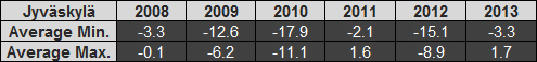
Looking at 2013 and its overall average temperatures, it's hard not to compare it to 2011. The biggest similarity of 2011 and 2013 was that both ended with unusually warm Decembers. One thing that is interesting to note is that, on the back of that extremely warm December 2011, late January and early February 2012 saw one of the coldest periods of the last 5 years. 2012 was also a much cooler year as a whole. Maybe 2014 has something similar to offer.

Wednesday, 8 January 2014

2013 Yearly Review - Sydney

2013 was a warm year. In fact, on a national scale, 2013 was the hottest year on record. Before we look at how Sydney fared, let's look at the conditions seen throughout Australia. The video below, the Annual Climate Statement 2013, was released by the Bureau of Meteorology on January 2 2014.


2013 was quite a remarkable year in terms of weather, particularly because of the warm temperatures experienced throughout Australia. This is further supported by temperatures and weather conditions seen in Sydney.

In Sydney, January was the warmest month of the year with both the highest average maximum and minimum. June had the lowest average maximum and July the lowest average minimum. The graph below shows the monthly averages for 2013. The dotted lines represent the long term average.

Monthly averages at Sydney Airport in 2013 (plus dotted line for long term averages)

It's clear to see that 2013's monthly figures beat every long term average. Winter minimums, plus those in September, were well above the long term averages, as were the maximums of July through to October. If we look at extremes for the year, the highest temperature was 46.4C on January 4 and the lowest was 5.2C on July 7. The lowest maximum was 13.2C on June 22 and the highest minimum was 23.8C on January 26.

Using Bureau of Meteorology measurements at Sydney Airport, some of the temperature records for 2013 include:
  • Sydney Airport saw its hottest temperature ever recorded - 46.4C on January 4 beat 45.2C from January 1 2006.
  • July had the highest average maximum on record - 19.6C beat 18.7C which was shared by 1946, 1975 and 2005. 
  • September had the highest average maximum on record - 25.2C beat 24.0C from 1980. 
  • September also had the highest average minimum on record - 13.8C beat 13.2C from 2006. 
  • The yearly average maximum was the highest on record - 24.0C beat 23.4C which was shared by 2005 and 2009.

My own records, which are based on recordings during a calendar day (i.e. midnight to midnight), differ slightly from some of the above values. These include:
  • 25.1C as the average maximum for September.
  • 13.7C as the average minimum for September.
  • 24.1C as the yearly average maximum for 2013.
  • 23.1C as the yearly average maximum for 2009.

Despite 2013 being the warmest on record, rainfall was still above the long term average. A total of 1246.0mm was recorded. This is compared to the long term average of 1084.8mm. 2012's measurement was 973.4mm. 2013's figure was 5.1mm short of 2011's mark, but prior to that you have to go back to 1999 to find a wetter year.

June was the wettest month with 305.6mm recorded. Only 15.6mm fell in August, making it the driest. The wettest day was January 28/29 with 104.6mm recorded in the 24hrs to 9am on the 29th. There was a total of 246 days, 67.4% of the year, without rain. Of the 119 days with rain, more than half, 65, had recordings at 5.0mm or less and only 7 days saw falls at or above 50.0mm.

The longest spell without rain was a 5 week period between August 9 and September 14. A 10 day period between June 22 and July 1 saw some level of precipitation every day, making it the longest rainy period of the year.

As usual in Sydney, there were a few windy days during 2013. The strongest gust of the year was 94km/h. This was recorded more than once. A westerly gust on August 12 was the first occurrence. A southerly on October 29 and another westerly on December 5 were the other two. I recall the October and December gusts originally being recorded at 95km/h on the respective days, as can be found in my previous blog posts, but it appears that BoM have updated them to 94km/h. The calmest day was July 13 with a strongest gust of only 19km/h.

It was an eventful year that broke several records. The third quarter of the year was the most unusual. A warm and mostly dry July, August and September made way for bushfires which raged around Sydney already in October. Several days soared above 30C in early spring and, in the end, it was the warmest year on record. You have to wonder what will come next, so let's see what 2014 will produce.

Sunday, 5 January 2014

Foggy start to the day in Jyväskylä, warm but breezy in Sydney

Fog blanketed Jyväskylä this morning as temperatures once again hovered above zero. Friday January 3 saw the first day entirely below zero since December 14 with a maximum of -1.0C, but temperatures rose yesterday to 0.3C. While there has been hardly any precipitation (only 0.2mm has been recorded at Jyväskylä Airport in the past 2 days), the air is very moist. Humidity levels have been around 95% for the past 36 hours.

This current weather trend should continue until Thursday night. Forecasts predict a drop in temperatures on Friday and into the weekend. Foreca's 10 day forecast for Jyväskylä shows a low of -12C for Friday, Saturday and Sunday, with cold temperatures continuing into early next week.

Fog in Jyväskylä on the morning of January 5 2014

The cloudiness measurement at Jyväskylä Airport was reading 9/8 between 6am and 11am

It was another nice summer's day in Sydney. The first 5 days of 2014 have been the warmest in the years since 2009. The daily maximum today was 29.0C. With a top of 36.8C, Thursday January 2 was the 6th warmest January day of the past 6 years. Minimums for the last 4 days have also been above 20C.

While it was warm in Sydney today, northerly and northeasterly winds were fairly strong. The strongest gust of the day, 72km/h, was recorded this evening at 6:26pm. Wind gusts above 50km/h had been measured since 1pm.

Sydney is in for a few cooler days between Tuesday and Thursday. Temperatures are predicted to reach only 22C on Tuesday and Wednesday and 23C on Thursday. There is also the chance of showers along with the lower temperatures.

Friday, 3 January 2014

December 2013 Review - Jyväskylä

December 2013 in Jyväskylä was a strange month in terms of weather. Even though the start of the month was warmer than some previous Decembers, there were some hints of an approaching winter, but it ended with warm weather, rain and questions being asked about when the true Finnish winter would really begin. The table below shows the averages since 2008.

December averages in Jyväskylä for the period 2008-2013

The average maximum of 1.7C was the warmest in the years since 2008, beating 2011's 1.6C. According to the Finnish Meteorological Institute, the overall average temperature for December 2013 in Jyväskylä was more than 5C higher than the 1981-2010 average. The strangest part about the warm weather in December was that it came towards the end of the month. The final 11 days had an average maximum of 4.0C. The same period in 2011 had an average of 1.7C while 2010's figure was -14.6C.

December 2011 held on to the highest average minimum of the 2008-2013 period though, as 2013's -3.3C was over a degree cooler. This is somewhat surprising considering there were a total of 13 days that didn't go below zero in 2013 compared to 7 in 2011 and 5 in 2008. Every December day in 2009, 2010 and 2012 went below zero at some point. However, 2011 had only 1 daily minimum below -10C compared to 5 for 2013.

In terms of extremes for the month, both the highest maximum of 5.9C from December 17 and the highest minimum of 3.4C from December 28 were the highest respective figures in the period since 2008. The lowest temperature of the month of -14.6C, as well as the lowest daily maximum of -6.2C, occurred on December 9. These figures were lower than those in both 2008 and 2011, but were still easily above those in 2009, 2010 and 2012.

Extremes elsewhere in Finland included a monthly high of 8.6C in Maarianhamina in the Åland Islands and a monthly low of -39.7C in Sodankylä in Lapland.

If we look at the past 6 Decembers in Jyväskylä, it is quite easy to divide them in to warm and cold ones. There are the warm Decembers of 2008, 2011 and 2013 and the cold Decembers of 2009, 2010 and 2012. The graph below shows the daily average temperature during each December.

Daily average temperatures in Jyväskylä for December in the period 2008-2013

The graph makes the distinction between the warm and cold Decembers much clearer. The yellow line, which indicates 2013, can also be seen above other years for the last 12 days, further highlighting the unusual warmth that was experienced.

Rainfall for December 2013 was above the 1981-2010 average. A total of 69mm was recorded in Jyväskylä, compared to 56mm last year and the average of 47mm. Snow was around for most of the first half of the month. A depth of 7cm was recorded on December 15, but the warm temperatures in the latter half of the month ensured there was no snow for Christmas or New Year's Eve. Kilpisjärvi in the far north had 117cm on December 4. By the end of the month this had dropped to 106cm.

Warm, humid southwesterly and southerly winds dominated for most of the month, contributing to the warmer temperatures. There were a couple of windy days to note, including December 1 and 13, when the storms Oskari and Seija hit Finland.

In the end it was a disappointing December that, while featuring a few cooler days at the beginning of the month, failed to deliver a white Christmas and New Year. Perhaps winter will arrive in January.

Thursday, 2 January 2014

December 2013 Review - Sydney

2013 ended with a rather warm December for Sydney. With an average maximum of 27.3C at Sydney Airport, it was easily above the long term average of 25.7C. It was also the warmest December in the years since 2009. According to Bureau of Meteorology records prior to that, it was the warmest December since 2005. The following table shows the averages since 2009.

December averages at Sydney Airport for the period 2009-2013

While the average maximum was the highest, the average minimum was the second lowest. Only 2011's cool December was lower. However, the figure was still above the long term average of 17.5C.

The lowest temperature of the month of 13.1C came on December 6, also the second lowest in the years since 2009. The highest daily minimum of 21.6C came on December 22, right in the middle for the past 5 years. The highest temperature of the month came on December 20, a hot day that reached 37.8C. As mentioned in a previous post, this was the hottest December day since 2005. The lowest maximum of the month was shared by Christmas Eve and Christmas Day when it reached only 21.5C. This was the warmest in the years since 2009.

Number of December days at certain temperature levels for the period 2009-2013

The graph above shows that even though there was a lower number of days above 30C for December 2013 compared to 2012, which has the second warmest December average maximum since 2009, the lack of cooler days helped to maintain a higher average maximum. If we look at the days above 30C for the years 2009, 2012 and 2013, the latter actually has the highest average, also helping to increase the overall average maximum for the month. The 6 days above 30C for 2009 had an average of 31.8C while 2012's was 32.8C and 2013's was 33.7C.

The monthly rainfall recording of 56.2mm was below the long term average of 73.5mm. Almost 40% of the monthly total, 21.8mm, fell in the 24 hours to 9am on December 16. BoM recorded no sunshine at the Airport on December 24 and 25, the only 2 days of the month without any sun, with Christmas Day accounting for another 15mm of rain.

The strongest wind gust of the month was a westerly at 95km/h, recorded during the afternoon of December 5. This equalled the record for the year; the other instance on October 29. The morning of Sunday December 29 also saw strong gusts. A southerly at 89km/h was the highest recorded.