Tuesday, 26 August 2014

Rain

Rain. That pretty much sums up the weather in Sydney and Jyväskylä recently.

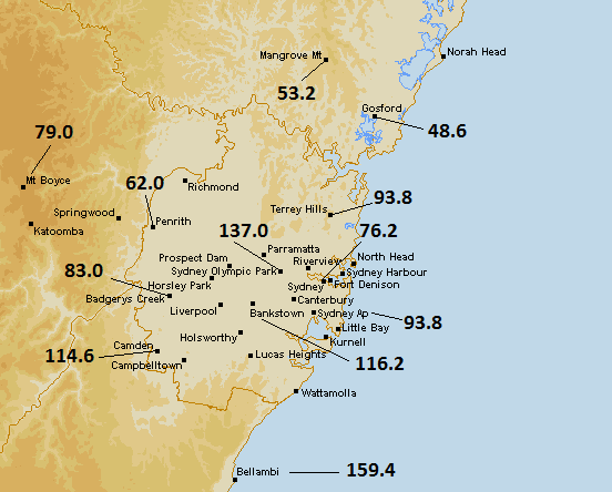
Sydney Airport recorded its 11th consecutive day of rain today. While Sunday and Monday only contributed 0.4mm and 4.6mm respectively to the monthly total, heavier rain returned today. A total of 31.8mm fell at the Airport, making it the 3rd wettest day of the month. Observatory Hill received slightly less with 19.4mm, but Bellambi on the coast south of the city saw 50.2mm. Rain after midnight in the early hours of August 27 means this year's record streak of 12 days from March and April has been equalled.

Today saw a low pressure trough move north along Australia's east coast. An associated low pressure system is sitting off the coast about half way up. The resulting south and southeasterly winds in Sydney have been accompanied by heavy and intermittent showers.

The monthly total at the Airport has now climbed above 200mm. Bureau of Meteorology records for the Airport since 2000 show a fairly consistent figure of one month per year recording more than 200mm. This August is the wettest month since June last year.

Those looking for respite from the rain are likely to get it from this weekend onwards. Spring temperatures above 20C are expected from the beginning of next week.

Like Sydney, a low pressure system is also responsible for rain seen in southern Finland during the last two days. In the Northern Hemisphere winds associated with low and high pressure systems move in the opposite direction to that seen in the Southern Hemisphere. A low has been slowly moving north from the Baltic States towards south-eastern Finland since the weekend. In Finland's case, rain has also been moving west, only to the north of the low pressure system rather than to the south. The synoptic charts below show the progress of the system from 3pm on August 25 to 3pm today.

Synoptic situation over Northern Europe at 3pm Finnish time on August 25 and 26
Source: Ilmatieteen Laitos (image altered from original)

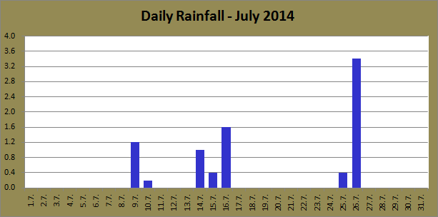
Jyväskylä has seen a decent amount of rain since the early hours of yesterday. A total of 6.9mm fell during Monday, while today has seen 21.5mm up until 9pm. There might be some more rain still before midnight, but as it stands, today has been the wettest day since July 31.

Temperatures have dropped further as well. As I said in my previous post, Monday was predicted to beat the previous lowest maximum for the month and it did just that, reaching only 14.9C. The failure to top 15C was the first since July 1. Today has been only slightly warmer, getting to around 15.5C.

Saturday, 23 August 2014

Showers and colder temperatures continue

There aren't many times during the year that Jyväskylä and Sydney see similar weather, but that's how it has been this week. There have been plenty of showers around in both cities and maximum temperatures have been hovering just above 15C.

The rain seen in Sydney last weekend continued throughout the week, although the falls weren't quite as heavy. Further rain today made it 8 consecutive days with rain recorded at Sydney Airport. The longest streak of rain days so far in 2014 is 12. The 12 days between March 21 and April 1 recorded 76.8mm. The past 8 days in Sydney have recorded much more than that, a total of 141.8mm.

August is now the wettest month of the year so far. March's 151.4mm total was overcome on Tuesday. A total of 21.6mm fell then. Thursday August 21 recorded 14.4mm and today has also recorded 10.0mm. The monthly total now stands at 192.0mm, almost one third of the current yearly total of 619.2mm.

The winter chill has carried on this week as well. The past few years have shown how unpredictable August can be in Sydney. For example, August 23 in 2012 got to 30.0C at the Airport. It only reached 17.2C today. That measurement made it the 13th consecutive day without a maximum above 18C. That equals the longest such streak in the years since 2009.

All Augusts between 2009 and 2013 had seen a temperature above 25C by this date. August 2014's current top is 22.9C. Despite the cool maximums, minimums have been slightly higher. The past week hasn't seen a measurement below 10C.

Summer has disappeared quickly in Jyväskylä. The first 7 days of August saw an average maximum of 27.4C, while the 7 days from August 16 have seen an average of only 18.3C. Tuesday's top of 16.1C is currently the lowest of the month. This low is likely to be beaten on Monday. These lower temperatures are fairly normal for this time of the year.

Like Sydney, Jyväskylä has seen a fair number of rain days lately. Including today, 10 of the past 13 days have seen rain recorded. The daily rainfall totals have been a lot lower than Sydney though. August 11 has been the wettest day so far with 9.4mm. The monthly figure now stands at 44.4mm.

Tuesday, 19 August 2014

Sydney and Jyväskylä see opposite extremes for August so far

Sydney and Jyväskylä have seen contrasting weather so far this August, and that's really how it should be considering the respective seasons. Jyväskylä's brilliant summer continued into the first 12 days of the month, while Sydney has seen some of the coldest days of this year.

The exceptional warmth at the start of the month can be clearly seen in the graph below which shows the progressive average maximum at Jyväskylä Airport for Augusts since 2009. The average maximum for this month peaked on August 7 at 27.4C. It has been declining since then as autumn draws closer, and after 18 days is almost exactly the same as the figure from 2010.

The average will continue to drop as the month continues, just like it did in 2010. Jyväskylä is unlikely to see any more days above 20C during the rest of the month. Due to a cold end to August 2010 and current forecasts that at least show maximums above 15C, August 2014 should be on track to record the highest average maximum in the years since 2009.

Progressive average maximum for August at Jyväskylä Airport for the period 2009-2014

Despite high maximums, and keeping in line with what was seen in July, minimums for Jyväskylä have been relatively low. After 18 days the average minimum sits as the third warmest since 2009, below 2010 and 2013. At the same point in August 2010, there had been 5 days with minimums above 15C. The highest so far this month is 13.6C, the lowest of the past 6 years. The average is likely to stabilise in the next week or so, probably on the way to an average between that of 2011 and 2013.

Progressive average minimum for August at Jyväskylä Airport for the period 2009-2014

If anyone in Sydney has been wondering whether it has been a cold August so far, then the answer is yes. The average maximum at August 19 is more than a degree lower than the next lowest figure from August 2010. After today, 2014 is also the only year since 2009 to have an progressive average below that of the all time average.

Current forecasts don't show any signs of spring arriving any time soon either. If the average maximum fails to go above 17.9C, as predictions suggest, August 2014 will have the coldest figure since 2008 and the second coldest since 1990.

Progressive average maximum for August at Sydney Airport for the period 2009-2014 plus the long term average
Despite having the lowest progressive average maximum, the minimum figure has climbed to almost equal with that of 2009. Only 2012 is lower. The figure is also well above the long term average. However, it is still more than 2C lower than 2011 and 2013.

2014 has seen the lowest August temperature since 2005, a 4.9C recording on the 3rd. After 19 days there have been 5 daily minimums above 10C, the same number as in 2010, and one more than in 2012. 2011 and 2013 had seen 10. Not surprisingly, current forecasts show the average minimum continuing to climb. It will probably end up quite close to 2010's figure.

Progressive average minimum for August at Sydney Airport for the period 2009-2014 plus the long term average

Monday, 18 August 2014

Past few days surpass rain predictions in Sydney

Sydney saw plenty of rain over the weekend and today. Rain had been forecast as part of a low pressure system that moved south from inland Queensland during Friday and Saturday, and final totals ended up surpassing predictions. In addition to the rain, today saw some very strong winds.

The first rain arrived a bit before 5:30pm on Saturday, slowly moving south through the city. By midnight a total of 14.2mm had been recorded at Sydney Airport. It rained almost continuously from 5:30pm on Saturday until midday Sunday. Yesterday managed to accumulate more than double Saturday's figure, a total of 31.0mm.

A subsequent 16 hour break in the rain was ended around 5am this morning. By that point, the low pressure system had moved off the coast and was pushing wind and rain in a northerly direction. A few showers preceded a heavier concentration of rain, and the hours between 6:30am and 9am accounted for 25mm. An additional 23mm fell during the rest of the day, taking the daily total to 48.6mm, the second highest of the year.

Rain totals across Sydney between August 16 and 18
Source: Bureau of Meteorology (image edited from original found here)

After a relatively calm day yesterday, when the strongest gust at the Airport was an easterly at 43km/h, the strong winds that were predicted finally arrived this morning. It was a rather wild morning for Sydney. In the midst of some of the heaviest rain of the past few days, winds increased suddenly at 7:52am at the Airport. A 41km/h west-northwesterly gust was recorded then. Winds quickly turned southerly and increased in strength. At 9:30am the average speed over 10 minutes was 70km/h, with a strongest gust at 89km/h. This was the second highest recording of the year. Wind gusts over 60km/h were experienced throughout the day.

Wind gusts were strong up and down the New South Wales coast. The weather station at Wattamolla Beach, about 30km to the city's south, recorded a strongest gust of 122km/h at 9:37am. Gusts above 100km/h were seen there throughout today.

Rain and strong winds eased slightly early this evening. More rain however is falling already in the early hours of August 19. Some heavy showers might continue into the late morning, while the rest of the week is likely to see showers also as temperatures stay below 20C.

Friday, 15 August 2014

Widespread rain across Eastern Australia expected this weekend

After heavy showers hit Sydney earlier this week, rain is expected to return this weekend. Sydney isn't the only location where rain is expected. Almost the whole east coast of Australia should see falls right up into early next week.

A band of rain associated with a trough developed over inland Queensland a couple of days ago. It has since been dumping some much needed rain to drought affected areas throughout Queensland. Towns such as Longreach, Emerald and Charleville are on target to record receive their biggest 24 hours to 9am falls since February and March.

The trough should move southeast overnight along with a low pressure system which today was sitting over the northeast corner of South Australia. Rain is likely to develop in Sydney tomorrow afternoon. Falls aren't predicted to be as heavy as Monday and Tuesday, but could be as high as 15mm tomorrow. Rain is forecast for Sunday also. The low pressure system will move off the east coast by Monday, and generate strong southeasterly winds across the Sydney region.

Forecast maps published on August 15 show a high probability of rain all along the east coast during the weekend.
Source: Bureau of Meteorology (screenshot unedited from original image)

Temperatures should also continue below 20C for the next few days in Sydney. Today was the warmest this week with a top of 17.6C. The current average maximum for August so far stands at 17.4C. Current forecasts have no days above 20C during the next week.

Thursday, 14 August 2014

Cool and wet weather for both cities

Rain returned to both Sydney and Jyväskylä at the beginning of this week. Sydney saw its biggest totals in more than 2 months, while Jyväskylä has seen its biggest fall so far this August. Temperatures have also remained low in Sydney, while Jyväskylä has seen a drop from recent summer maximums above 25C.

After Monday saw 8.0mm fall at Sydney Airport, a further 40.2mm fell on Tuesday. That 40.2mm recording from August 12 is more than all of the rain that fell between June 7 and August 11. An additional 0.2mm yesterday took the monthly total to 50.2mm.

Monday's cold continued on Tuesday as well. Most of the day remained below 13C, but it did exceed the previous day's top by 0.1C, getting to 13.2C. Yesterday was only slightly warmer than that with a maximum of 14.4C. That made it 3 consecutive days without topping 15C. Since 2009, only 2011 and 2012 had managed 4 consecutive days below 15C, but today's high of 16.5C made sure that 2014 wouldn't join that list.

Minimums have been in line with the season as well. After 2 weeks of August the highest minimum stands at 10.1C, one of only two days with a minimum above 10C. All years between 2009 and 2013 recorded a warmer minimum by August 14.

The gorgeous run of summer weather in Jyväskylä came to an end after Monday. August 11 did manage to post a top above 25C, but rain in the late evening dropped temperatures below 20C. Tuesday then recorded the coldest day since July 16. Yesterday went even lower with a maximum of 20.4C, the coldest since July 10.

Showers rolling through Jyväskylä just after 4pm on August 13

Late Monday evening saw 9.4mm of rain. Tuesday and Wednesday added 4.7mm and 3.3mm respectively to the monthly total which, not including today, stands at 18.2mm. Showers are expected for at least the next week.

Monday, 11 August 2014

Temperatures stable in Jyväskylä during past week, fluctuating in Sydney

Temperatures remained warm in Jyväskylä over the weekend, even if they were slightly down on last week's figures. It's quite possible that it was the last weekend of the year with temperatures close to 25C.

Tuesday to Friday last week pushed the streak of days above 25C to 10, but Saturday fell short by 0.7C, getting to 24.3C. Tuesday August 5 saw the highest temperature of the month with 28.9C. Since 2009, only 2010 recorded a warmer August temperature. Wednesday and Thursday came very close to Tuesday's figure with 28.8C recorded on both days. After the 30.8C top from 2010, these 3 days are the second and equal third warmest August days since 2009.

Jyväskylä has already recorded more August days at 25C or above in 2014 than any year between 2009 and 2013. Today made it 10 days above the mark. 2010 recorded 6 days at or above 25C, 2009, 2011 and 2013 saw only 2, and 2012 saw none.

The first precipitation for the month was recorded last Thursday afternoon. A few isolated showers have been passing through Central Finland since then, but most have avoided Jyväskylä. Thursday saw 0.5mm and yesterday also saw 0.3mm recorded.

The rest of this week will see the first signs of the impending autumn. It's very possible that today was the last day of the year above 25C. Daily maximums should hover closer to 20C heading all the way into next week.

Some rain is expected tonight, 0.8mm has already fallen by 9pm today, and the long term forecast shows the chance of showers all the way towards the end of next week. This rain is the first for quite some time that isn't associated with storm activity, a further sign of the autumn drawing near.

Isolated storms and showers threatened Jyväskylä during the evening of August 10.
Despite rain in the city, no rain was recorded at Tikkakoski.

It has been a mix of typical winter weather and early signs of spring for Sydney since the start of last week. During the past week, 3 days at Sydney Airport have recorded daily maximums above 21C. The pick of those was yesterday's top of 22.9C, the warmest of the month so far. Saturday had reached 21.2C. The remaining 4 days saw temperatures below 19C.

After a fairly warm weekend, today was a very cold day, the coldest of the year. In fact, Sydney Airport recorded its coldest maximum in more than 3 years. The top of 13.1C was the coldest since it hit only 12.8C on July 15 in 2011. You have to go back another 3 years to 2008 to find the next coldest.

Last Tuesday and Friday saw a small amount of rain. This morning also saw a brief shower with 0.8mm recorded before 9am. This evening, however, saw heavy showers develop south east of the city and move in a northwesterly direction. The daily total at Sydney Airport had climbed to 8.0mm by midnight. Further rain has already fallen in the early hours of August 12 as well, a total of 17.0mm between midnight and 4am. This is the highest daily total since June 5.

Thursday, 7 August 2014

July 2014 Review - Jyväskylä

It was an unusually warm July for Jyväskylä in 2014. Records from the Finnish Meteorological Institute place July 2014 as the sixth warmest July since at least 1961. More than half of the month recorded days above 25C. It was mostly dry and sunny, but a couple of stormy days pushed the rainfall total close to the long term average. Elsewhere in Finland, most of Lapland recorded its warmest July in 30 years.

The graph below shows the July averages at Jyväskylä Airport from 2009 to 2014.

July averages at Jyväskylä Airport for the period 2009-2014

The inconsistency of Finnish summer can be partly seen in the graph above. The average maximum for 2014 was 4.5C higher than last year. Despite recording the second highest average maximum since 2009, 2014's average minimum was lower than 2011. The overall average for the month of 19.0C, as stated by FMI, was 2.5C above the 1981-2010 average. My own recordings put the average at 18.5C, but that is still much warmer than the long term figure.

Compared to the previous 5 years, 2014 had the largest difference between the average minimum and maximum. This generally meant warm days but cooler nights. July 13 to 31, however, didn't see a temperature below 10C. Since 2009 only 2010 had a longer streak above 10C for July.

July 2014 recorded the 8th and 9th days above 30C since 2009. The 25th got to 30.3C while 30.2C was recorded the very next day. The 23rd and 27th came very close to the 30C barrier, both recording tops of 29.9C. The month's highest minimum came on the very last day, a 15.3C recording.

The very first day was the month's coldest with a maximum of only 14.3C. The lowest overall temperature came on July 11. The 4.3C figure recorded then was the only day that went below 5C.

The warmest temperature recorded in Finland during July 2014 was 32.5C on July 26 at Kouvola's Utti Airport. Finland saw a total of 26 hellepäivät (days above 25.1C) during the month. This was the 5th highest figure since at least 1959. 2010 and 1973 hold the record with 30 while the long term average is 16. Jyväskylä saw 18 hellepäivät during the month. That is compared to 21 in 2010.

As mentioned earlier, rainfall was below average. The 1981-2010 average for July in Jyväskylä is 84mm. FMI's 68mm figure (my own recording was 69.2mm) was also lower than last year's 76mm reading. There was a total of 11 rain days. The longest streak without rain was 11 between July 17 and 27.

Daily rainfall totals at Jyväskylä Airport for July 2014

Brilliant summer conditions dominated the month, but there were some very dangerous storms around at times. One storm led to the wettest day of the month at Jyväskylä Airport. The 14th saw a total of 23.3mm fall. July 31 also saw 22.1mm as a result of storm activity. Oulu, in Finland's north, saw the highest daily total during the month. On July 18 62.3mm was recorded. An incredible 59.2mm of that fell within 1 hour.

FMI reported a monthly total of around 110,000 lightning strikes throughout the country. This is compared to the average of around 59,000. July 31 alone saw about 22,000 strikes as very dangerous storms struck the western half of the country.

Tuesday, 5 August 2014

July 2014 Review - Sydney

It was a fairly warm, rather dry and mostly sunny July for Sydney in 2014. Most of the month was slightly above average at Sydney Airport, but a late flurry of warm days pushed the average maximum up to the second highest on record. Less than 10mm of precipitation was recorded, making it the sixth driest July on record.

The graph below shows the average minimums and maximums at the Airport since 2009. The long term average is also shown.

July averages at Sydney Airport for the period 2009-2014 plus the long term average

After setting the record last year for the highest average maximum, 2014 served up the second highest since 1939. With 3 days remaining in the month the average stood at 18.1C, but tops of 23.9C, 25.1C and 25.8C, the month's 3 warmest days, helped it climb above the 18.7C average shared by 1949, 1975 and 2005. As mentioned previously, July 30 and 31's maximums made it the first time on record for 2 consecutive July days above 25C. They also marked only the 8th and 9th July days above 25C since 1939.

Also with 3 days remaining, the average minimum looked like it would be the coldest since 2008. July 29 to 31 pushed that figure from 8.3C to 8.7C.

July 2014's overall top of 25.8C was the second highest July temperature on record. July 31 also recorded the month's highest minimum, a reading of 13.4C. The month's coldest day came on the 13th when it only reached 14.1C. July 19 and 20 were the only other days that failed to go above 15C. The coldest temperature of the month was recorded during the morning of July 9, a chilly 5.7C.

July is typically the second driest month of the year for Sydney, but rainfall for 2014 was well below the average of 70.6mm. A monthly total of only 8.2mm made it the sixth driest July at the Airport since 1930. Rain was recorded on only 7 days of the month. July 26 was responsible for the highest daily rainfall, a measly 3.4mm.

Daily rainfall totals at Sydney Airport for July 2014

There were 2 streaks of 8 days without rain during the month. July 1 to 8 extended the 14 day streak from the second half of June to 22, while July 17 to 24 also saw no falls.

Winds were up on last year's figures. July 2014 saw an average maximum daily gust of 44.9km/h, compared to 38.2km/h last July. July 9 saw the month's strongest with a westerly at 81km/h. The weakest gust, a northwesterly at 22km/h, was recorded on the 23rd. This was also the weakest highest daily gust since May 18.

Another interesting observation that can be seen in the Bureau of Meteorology records is that the first 13 days of the month were almost entirely cloud free. July 1 to 13 all recorded more than 9 hours of sunlight each. With a maximum of around 10 hours possible per day at that time of year, that run is quite remarkable.

Monday, 4 August 2014

Unusual extremes for Sydney in the past week, summery weather continues in Finland

Sydney has seen some unusual extremes during the past week. July ended very warm, but August has started off in cold fashion. Dry weather has also continued despite the changing temperatures.

After recording what was the 5th warmest July day since 1993 on the 29th with 23.9C, Sydney Airport quickly relegated that measurement to the 7th warmest. Both July 30 and 31 pushed above 25C, a rare achievement for July. The last 3 days of July pushed the average maximum from 18.1C to 18.8C.

A top of 25.1C was recorded on the 30th, before the 31st pushed up to 25.8C. This was the warmest day at the Airport in more than 2 months. The 25.8C recording was also the equal second warmest July day in the Airport's 76 year history. Including last Wednesday and Thursday, since 1939 there have been only 9 July days above 25C. Only July 1975 recorded 2 days above the mark, and this was the first time for 2 consecutive days.

The change of month was met with a fairly dramatic drop in temperatures. August 1 saw a top 6C lower than the previous day, and the month's second day saw the coldest daily maximum of the year so far. Observatory Hill managed to reach 16.1C, but it didn't even pass 14C at the Airport, only getting to 13.8C. It was the coldest day since August 8 last year.

The following morning saw a very chilly start. Something that has become increasingly rare over the past two decades is a temperature below 5C. August 3 had a minimum of only 4.9C. It was the first time below 5C at the Airport since June 30 in 2010. It was also only the 3rd time in the past 7 years that it has dropped below 5C.

Daily minimums and maximums at Sydney Airport during the past 2 weeks

Recent dry weather has continued in Sydney as well. Today pushed the current streak to 9 days without rain. Since June 15 the Airport has seen less than 10mm of precipitation.

Every day since my last post has topped 25C at Jyväskylä Airport. Finland's warm spell has lasted about a month so far. Of the past 19 days only July 29 failed to go above 25C, and it was mighty close then with a top of 24.8C. Minimums have also been high. Temperatures haven't actually dropped below 10C since July 12.

Helsinki also saw some glorious weather over the weekend.
This was the view from Suomenlinna on August 1.

After missing heavy rain from storms on July 29 and 30, Tikkakoski finally received good falls on the 31st. Rain in the early hours of the morning dropped around 22mm. The first few days of August have remained rain free.