New Year's Eve 2013 was a nice and warm day in Sydney. Temperatures at the Airport peaked at 30.2C just before 4pm. Today was the warmest New Year's Eve of the past 5 years in Sydney. It hovered around 26C for most of the day though as a result of easterly winds. By the time the fireworks go off at midnight it should be around 20C, which is fairly comfortable for those out and about.
Jyväskylä woke up to snow this morning. Temperatures dipped below zero for the first time since December 20 as well. Only a small amount of snow fell though and with temperatures currently at 1.6C and a forecast for 2C, it won't be around for long. New Year's Eve 2008 saw a daily maximum of 2.2C, the warmest of the last 6 years. Today will come close to, if not surpass, that figure.
2014 will start off warm in Sydney with mostly sunny weather and 28C predicted for tomorrow. 33C is forecast for Thursday. Jyväskylä will continue its above average trend with the chance of rain overnight and a top of 3C tomorrow.
Tuesday, 31 December 2013
Sunday, 29 December 2013
Above average temps continue for Finland, strong winds in Sydney
The last few days in Finland have seen above average temperatures continue. Including today, the past 5 days have a daily maximum above 4C, with 3 of those days not going below 3C. The highest monthly minimum was set again yesterday; it now stands at 3.4C.
Minus temperatures seem like a distant memory for Jyväskylä. In fact, it hasn't dipped below zero since December 20, 9 days ago. Of the 5 years prior to 2013, the latest time in the year for 9 consecutive days above zero was last year between November 17 and 26, a total of 10 days. Compare that to 2010 and you'll have to go back to the start of October. Also in 2010, the last day of the year entirely above zero was November 4. Since November 4 this year, there have been 21 days entirely above zero.
Today's maximum of 4.4C helped the monthly average maximum equal 2011's mark of 1.6C. With only 2 days remaining in the month and a maximum of 2C forecast for both, it should reach 1.7C. The average minimum for December, however, will stay below 2011's figure.
Sydney saw some strong winds this morning. A southerly change hit the city just after 5am. Winds picked up in the following hour and gusts remained at 80km/h or above between 6am and 8am. The strongest gust was 89km/h at 6:31am. That was the strongest recording since December 5. The rest of the day was rather cool, although it didn't dip below 20C all day.
Elsewhere in Australia, the Pilbara region in Western Australia is bracing for Tropical Cyclone Christine. It is currently a Category 2 storm, but is predicted to strengthen to a Category 3 by the time it makes landfall between Port Hedland and Karratha tomorrow evening. The Bureau of Meteorology is warning of gusts exceeding 165km/h and heavy rainfall as the cyclone crosses the coast and moves inland.
Wednesday, 25 December 2013
A wet Christmas
Both Jyväskylä and Sydney are having Christmas weather most people wouldn't have hoped for. Mild temperatures and rain continue in Finland while it rained in Sydney today as well.
It was a rather cool day for Sydney with the top temperature being 21.5C. It also reached the same figure yesterday and now both Christmas Eve and Christmas Day share the lowest maximum of the month with less than a week to go.
Rain swept across the city this morning and while the falls weren't too high, it didn't ease until just after midnight. At the Airport 15mm was recorded. The largest falls around Sydney were in the Blue Mountains and on the coast south of the city. At 1am on December 26, Bellambi had received 59.4mm during the previous 13 hours.
The graph below shows the minimums and maximums for December 25 in the past 5 years. Today had the lowest maximum of the most recent 5 Christmas Days in Sydney.

In Jyväskylä the trend of wet weather, cloud and above zero temperatures continued. In the 24 hours prior to 4pm, 9.1mm has fallen at Jyväskylä Airport and more is on the way. Just before midnight yesterday the temperature rose above 3C and it has remained around 4C for the past 12 hours. Forecasts predict it to continue like that until tomorrow morning.
While Sydney had its coolest Christmas Day of the past 5 years, Jyväskylä had its warmest of the past 6.

On the weekend it looked like there might be some snow around in Suonenjoki for Christmas, and there was, but it could have been so much better.
It was a rather cool day for Sydney with the top temperature being 21.5C. It also reached the same figure yesterday and now both Christmas Eve and Christmas Day share the lowest maximum of the month with less than a week to go.
Rain swept across the city this morning and while the falls weren't too high, it didn't ease until just after midnight. At the Airport 15mm was recorded. The largest falls around Sydney were in the Blue Mountains and on the coast south of the city. At 1am on December 26, Bellambi had received 59.4mm during the previous 13 hours.
The graph below shows the minimums and maximums for December 25 in the past 5 years. Today had the lowest maximum of the most recent 5 Christmas Days in Sydney.
In Jyväskylä the trend of wet weather, cloud and above zero temperatures continued. In the 24 hours prior to 4pm, 9.1mm has fallen at Jyväskylä Airport and more is on the way. Just before midnight yesterday the temperature rose above 3C and it has remained around 4C for the past 12 hours. Forecasts predict it to continue like that until tomorrow morning.
While Sydney had its coolest Christmas Day of the past 5 years, Jyväskylä had its warmest of the past 6.
 |
| It was still white a few days before Christmas. Kokkolampi in Suonenjoki, December 21 2013 |
 |
| Unfortunately the good snow didn't hang around. Conditions in Suonenjoki on Christmas Day 2013. |
 |
| The perfect Finnish Christmas weather was in 2010. Laukaa, December 24 2010 |
Whatever the weather may be, Merry Christmas!
Monday, 23 December 2013
Another hot one in Sydney, miserable weather continues in Jyväskylä
It was hot again in Sydney today. It was a strange day though with plenty of wind changes. There was a warm morning, a very brief period over 35C and a cool afternoon.
The morning started fairly warm with easterly winds. At 12:30pm it was 26.7C after reaching 29C around 11am. It wasn't until the northwesterlies came that the temperature spiked upwards. As a result of the wind change, it jumped almost 10C to 36C between 12:30pm and 1pm; the daily maximum of 36.6C coming at 2:23pm. This was the second warmest December temperature since 2005, after last Friday's 37.8C.
The temperature dropped soon after, similarly to the way it had risen earlier. This time it was a southerly change that hit the city just after 3pm. By 3:30pm it was only 23.3C. The southerly change brought some strong winds also, 72km/h the strongest gust at 3:31pm.
After the hot day on Friday, Saturday was much cooler, but temperatures rose again yesterday reaching 31.2C. At Penrith in Sydney's west it was 41.0C. Yesterday was also responsible for the highest minimum of the month so far, 21.6C.
Meanwhile in Jyväskylä, miserable weather continues. For this time of the year, it's just not good. The last 3 daily maximums including today have been between 3.4C and 4.1C and it hasn't been below zero since Friday. In addition to that, there has been wet snow, rain and a lot of cloud.
Yesterday's minimum of 2.8C was responsible for the highest minimum of not only the month, but of all December days in the period since 2008. The previous record dates back to December 12 this year when it was 1.7C. Prior to that though you have to go back to December 3 2008 when the daily minimum was 1.3C. The latest date in the year for a minimum as high or higher than 2.8C in the period since 2008 was 4.0C on November 27 2009.
The monthly averages are still holding below December 2011's figures thanks to a few colder days earlier in the month, but with the current forecasts it's hard to see at least the average maximum not going higher by the time December is done. The highest temperatures for the coming days are predicted to be 1C, 5C, 3C, 3C and finally 2C. The current averages are -4.8C and 0.9C, compared to 2011's -2.1C and 1.6C.
The warmer temperature have been due to a series of low pressure systems around Iceland and in the Norwegian Sea that have been pushing southwesterly winds across the northern half of Europe for quite some time now. A forecast released by the European Centre for Medium-Range Weather Forecasts (ECMWF) predicts warmer than average weather to continue in Finland for the whole 4 weeks between December 23 and January 19. So those in Finland should get used to the current weather as it looks like it'll be here for at least another few weeks.
Friday, 20 December 2013
Sydney Airport records warmest December day since 2005, snow in Jyväskylä
It was hot in Sydney today. At Sydney Airport it reached 37.8C at 12:51pm. Based on my own recordings it is the warmest December day at least in the period since 2009. If you look at Bureau of Meteorology records, you have to go back almost 8 years to find a December day warmer than today; Christmas Eve in 2005 when it was 38.3C.
It was a little cooler at Observatory Hill where it only reached 33.5C. Penrith in the far west of the city was the hottest location in the Sydney region with 41.9C at 3:38pm. Today was also the warmest day since that unusually hot day in early October. The daily maximum for October 10 reached the same as today, 37.8C.
Tomorrow in Sydney should be cooler with southerly winds, but temperatures are expected to climb back into the 30s on Sunday and Monday. The current Christmas Day forecast is a balmy 25C.
I have temporarily moved to the town of Suonenjoki, about 80km to the northeast of Jyväskylä, for the Christmas period, but it has been snowing in Jyväskylä this morning. The snow depth at Jyväskylä Airport has climbed to 6cm.
Current and predicted temperatures still aren't too good though with 0.1C the current reading and 2C forecast for later today. Sunday's 3C is even worse. There is definitely more snow in Suonenjoki though so I might be lucky enough to get a white Christmas after all. It's a bit touch and go in Jyväskylä, but there will probably be at least a little of the white stuff around.
Tuesday, 17 December 2013
Highest December temperature in Jyväskylä in last 6 years
Just before 5am this morning the temperature hit 5.9C at Jyväskylä Airport. This is the warmest December temperature in the period since 2008. The previous record of 5.8C was measured on December 27 2011 during the Tapani storm.
This morning's temperature was also the warmest in a month; 6.4C was recorded on November 17. It's quite a contrast to December 17 2009 when the daily minimum and maximum read -26.1C and -18.3C. These were responsible for both the lowest monthly minimum and the lowest monthly maximum for December that year.
Winds weren't quite as strong as predicted yesterday. The strongest gust in Finland this morning of 23m/s was recorded in Niinisalo, 175km southwest of Jyväskylä. In addition to the winds, rain fell in Jyväskylä for the first time in a few weeks.
There is pretty much no snow left in Jyväskylä. Only random chunks of ice are visible in gutters, parking areas and on some footpaths. Unless there is a surprise snowfall on or just before Christmas Eve, it looks like it'll be a black Christmas for most of the country.
Monday, 16 December 2013
Warm weather returns to Finland, showers in Sydney
Temperatures in Jyväskylä could climb to over 5C later tonight and early tomorrow morning as strong westerly winds batter the southern half of Finland. Wind warnings are in place for all coastal areas as well as Central Finland. The Finnish Meteorological Institute warns inland gusts could exceed 20m/s, with the worst of the winds around 5am.
The mercury went above zero just before midnight yesterday and has been holding steady at 1.3C and 1.4C for the last 5 hours or so. Saturday evening saw the second coldest temperature of the month, -13.8C at 6pm. It has been climbing since then and should continue to do so this evening.
Brief but heavy showers hit parts of Sydney this morning. Sydney Airport and surrounding areas received the biggest falls. The Airport has recorded 26mm today. The majority of that, 24.4mm, fell between 6:40am and 9:30am. Temperatures still reached above 25C later in the day though; 25.1C the recording at 1:29pm.
The average maximum so far for December stands at 27.0C. This is equal with 2012's figure. No other December since 2009 is higher than that. Should the weather continue the way it has been going so far this month, this will be the warmest December in the last 5 years. The current forecast seems to support that idea. It's an absolute beauty at the moment with maximums ranging between 26C and 30C for the coming 7 days.
Saturday, 14 December 2013
Week long run of 25C+ ends for Sydney Airport, sunny but cold in Jyväskylä
Sydney Airport's week long run of 25C+ temperatures ended today. Only just though; it was 24.9C at 3:25pm. Observatory Hill was slightly warmer, reaching 26.7C, making today the 8th day in a row above 25C. For the Airport, which is more vulnerable to southerly winds, the 7 day run above 25C was the longest since the 9 day period between March 20 and 28.
Moderate southerly winds kept temperatures low for most of the day with the stronger gusts earlier in the morning. While it was a little cooler, the predicted showers stayed away from most parts of the city. The Blue Mountains and locations on the coast near Wollongong and further south received the biggest falls.
It's much cooler in Finland after a few warm days. The temperature in Jyväskylä just dropped below -11C. It had been hovering just above -10C for 3-4 hours after steadily declining from around -2C since 3pm yesterday. It had dropped to -5.5C by midnight.
During early yesterday morning the storm named Seija marched east through the lower half of Finland. The highest recorded gusts weren't quite as strong as those from Eino in November, but they were still strong enough to cut power and bring down trees. Locations in the south and west were worst affected. 70,000 homes were still without power yesterday evening.
Helsinki-Vantaa Airport recorded the strongest gust for an inland location; 29.8m/s (107km/h). For coastal areas, Kaskinen, a small town on the west coast, experienced an average wind speed over 10 minutes of 30.7m/s around 3am.
Jyväskylä also experienced strong winds briefly yesterday morning. The strongest winds hit just before 6am. I saw a wind gust recording of 19m/s around 8am, but from looking at the average wind speeds during those hours, it's likely that the highest gust already occurred around 6am.
It's hard to believe now that there had been such strong winds because, in addition to the clear skies, it's dead calm.
Thursday, 12 December 2013
Bye bye snow
Jyväskylä has been increasingly wet and sloshy over the past 48hrs as warm temperatures continue to melt more than 10cm of snow. Warm air is being pushed all the way to Finland from off the west coast of Africa. This warm air has been causing temperatures to rise in the United Kingdom and across the Nordic countries.
Many locations in Finland topped 5C yesterday, including Oulu, 310km north of Jyväskylä, where it reached 8.2C. The maximum temperature for Jyväskylä was 4.1C. This overtook December 3's monthly maximum of 3.9C and it was the warmest day since November 27. In the years since 2008, only 2011 has seen temperatures this warm this late in December. Yesterday's minimum of 0.9C was also the warmest in 3 weeks. Today's current minimum of 1.7C is even warmer.
The warm temperatures haven't been good for those hoping for a white Christmas. Most of the snow has melted already and long term forecasts aren't looking good with warm temperatures expected next week also.
The last two days in Sydney have been quite nice. Temperatures there have continued in the high 20s with 29.4C yesterday and 27.0C today. 27C is forecast for tomorrow also, although it should be slightly cooler over the weekend.
I didn't point it out in my previous post, but Tuesday's 34.4C in Sydney was the 3rd warmest December day in the period from 2009. December last year saw 2 days which were warmer; 36.2C on December 1 and 34.6C on December 20.
Many locations in Finland topped 5C yesterday, including Oulu, 310km north of Jyväskylä, where it reached 8.2C. The maximum temperature for Jyväskylä was 4.1C. This overtook December 3's monthly maximum of 3.9C and it was the warmest day since November 27. In the years since 2008, only 2011 has seen temperatures this warm this late in December. Yesterday's minimum of 0.9C was also the warmest in 3 weeks. Today's current minimum of 1.7C is even warmer.
The warm temperatures haven't been good for those hoping for a white Christmas. Most of the snow has melted already and long term forecasts aren't looking good with warm temperatures expected next week also.
 |
| Wet and icy paths were a common sight in Jyväskylä today as a result of warmer temperatures |
 |
| The ugly side of winter showed itself today |
The last two days in Sydney have been quite nice. Temperatures there have continued in the high 20s with 29.4C yesterday and 27.0C today. 27C is forecast for tomorrow also, although it should be slightly cooler over the weekend.
I didn't point it out in my previous post, but Tuesday's 34.4C in Sydney was the 3rd warmest December day in the period from 2009. December last year saw 2 days which were warmer; 36.2C on December 1 and 34.6C on December 20.
Tuesday, 10 December 2013
Don't always believe the forecast
So in my post yesterday I commented that Sunday December 8 was the first day with a maximum below -5C and that yesterday December 9 was the first day with a minimum below -15C. Well it looks like I spoke too soon.
The forecast at the time predicted a low of -19C by 2am this morning having dropped to -17C by 11pm yesterday. Shortly after I submitted my post, the forecast had been revised to -16C by 2am. Another hour later and it was revised to -12C.
So the lesson here is to not always believe the forecast 100% of the time (probably something we all know already). I have updated the table from yesterday's post, as shown below. Long term forecasts for warmer weather in the coming weeks might mean Jyväskylä will wait until January to fill that box.

FMI releases a daily map image showing temperature distribution throughout Finland during 24 hours from 8am to 8am. The image below is today's edition for low temperatures.
So it turns out that Jyväskylä, shown by the red dot, wasn't far off having those colder temperatures. In Kuopio, 120km to the north east of Jyväskylä, it was around -21C this morning. In many locations further east and to the north it went below -30C.
Sydney also defied forecasts today. The forecast yesterday predicted a top of 28C, but it went well above that reaching 34.4C at the Airport. The predicted overnight low of 22C was also below the actual. In fact it hasn't gone below 24C for almost 36 hours so far. Predicted rain this morning also didn't eventuate. No stations in Sydney recorded any rainfall today.
The forecast at the time predicted a low of -19C by 2am this morning having dropped to -17C by 11pm yesterday. Shortly after I submitted my post, the forecast had been revised to -16C by 2am. Another hour later and it was revised to -12C.
So the lesson here is to not always believe the forecast 100% of the time (probably something we all know already). I have updated the table from yesterday's post, as shown below. Long term forecasts for warmer weather in the coming weeks might mean Jyväskylä will wait until January to fill that box.
FMI releases a daily map image showing temperature distribution throughout Finland during 24 hours from 8am to 8am. The image below is today's edition for low temperatures.
 |
| Minimum temperatures throughout Finland between 8am 9.12.2013 and 8am 10.12.2013 Source: Finnish Meteorological Insitute |
So it turns out that Jyväskylä, shown by the red dot, wasn't far off having those colder temperatures. In Kuopio, 120km to the north east of Jyväskylä, it was around -21C this morning. In many locations further east and to the north it went below -30C.
Sydney also defied forecasts today. The forecast yesterday predicted a top of 28C, but it went well above that reaching 34.4C at the Airport. The predicted overnight low of 22C was also below the actual. In fact it hasn't gone below 24C for almost 36 hours so far. Predicted rain this morning also didn't eventuate. No stations in Sydney recorded any rainfall today.
Monday, 9 December 2013
Warmest day in a month in Sydney, coldest day in almost 9 months in Jyväskylä
Sydney returned to temperatures above 30C today for the first time in a month. The 32.0C measurement at 2:31pm was the warmest since November 8 when it reached 34.0C. The daily minimum of 20.0C was also the highest since November 22.
The prediction for last Friday of a low of 13C was right on the money. The low of 13.1C became and will probably remain as the overall monthly low. Friday's top of 21.8C is also the lowest maximum so far of the month. The weekend was warmer, slowly climbing towards today's 30C+ temperature with 25.6C for Saturday and 27.6C for Sunday. No rain fell over the weekend after 3.4mm across last Thursday and Friday.
Today in Jyväskylä has been quite cool. The maximum so far stands at -6.1C from around 4:30am. With it currently at -10C and unlikely to climb as high again this evening, it will mean this is the coldest day since March 18 when the temperature topped -6.3C. It had already dropped to -14.5C briefly earlier this evening before climbing again in the last 90 minutes.
The following table details the first dates of each winter that experienced a maximum below -5C and a minimum below -15C. Yesterday and today were responsible for this year's respective values (assuming it will drop below -15C later this evening as predicted).

This winter's values are fairly average if we consider the previous 5. The real winter isn't quite here just yet though. Overnight temperatures are predicted to drop to -19C, but rise again to the positive tomorrow evening. 3C and 2C are forecast for Wednesday and Thursday.
The 10 day forecast from Foreca doesn't look very good for those hoping for a white Christmas either, with it currently predicting 3C, 4C and even 5C from Sunday into early next week. FMI currently has a snow depth of 14cm for Jyväskylä Airport, but if temperatures go in the coming days and next week, it won't be there for long.
Winter has certainly arrived in Finland's far north though. In Kilpisjärvi in the far north west near the borders of Sweden and Norway, it was -37.5C earlier today. It has been -32C or below for the last 48hrs. They also have over a metre of snow!
The prediction for last Friday of a low of 13C was right on the money. The low of 13.1C became and will probably remain as the overall monthly low. Friday's top of 21.8C is also the lowest maximum so far of the month. The weekend was warmer, slowly climbing towards today's 30C+ temperature with 25.6C for Saturday and 27.6C for Sunday. No rain fell over the weekend after 3.4mm across last Thursday and Friday.
Today in Jyväskylä has been quite cool. The maximum so far stands at -6.1C from around 4:30am. With it currently at -10C and unlikely to climb as high again this evening, it will mean this is the coldest day since March 18 when the temperature topped -6.3C. It had already dropped to -14.5C briefly earlier this evening before climbing again in the last 90 minutes.
The following table details the first dates of each winter that experienced a maximum below -5C and a minimum below -15C. Yesterday and today were responsible for this year's respective values (assuming it will drop below -15C later this evening as predicted).
This winter's values are fairly average if we consider the previous 5. The real winter isn't quite here just yet though. Overnight temperatures are predicted to drop to -19C, but rise again to the positive tomorrow evening. 3C and 2C are forecast for Wednesday and Thursday.
The 10 day forecast from Foreca doesn't look very good for those hoping for a white Christmas either, with it currently predicting 3C, 4C and even 5C from Sunday into early next week. FMI currently has a snow depth of 14cm for Jyväskylä Airport, but if temperatures go in the coming days and next week, it won't be there for long.
Winter has certainly arrived in Finland's far north though. In Kilpisjärvi in the far north west near the borders of Sweden and Norway, it was -37.5C earlier today. It has been -32C or below for the last 48hrs. They also have over a metre of snow!
Thursday, 5 December 2013
Windy day in Sydney
Strong winds picked up this afternoon in Sydney dropping temperatures and affecting transport throughout the city.
There was a brief shower earlier in the day, but it warmed up afterwards topping 25C around midday and reaching the daily maximum of 27.5C at 2:21pm. Winds were gusting around 50km/h for most of the morning before the gusts increased to 70km/h by 2:30pm. That's when the temperature dropped.
Three westerly gusts between 3:18pm and 3:25pm measured 95km/h, matching the yearly record set on October 29. At that time it was the strongest gust in over a year. At 4pm the temperature was reading only 15.8C. The strong westerlies have continued for the last few hours and shouldn't die down until tomorrow morning.
Traffic and transport throughout the city was affected this afternoon as the winds brought down trees onto roads and rail lines. Several sets of traffic lights were blacked out also as a result of widespread power failures.
The cooler temperatures are the result of strong southerlies as part of a low pressure system which moved east over Victoria today. Cold air has been pushed from south of Tasmania, and as the southerly winds have moved further north they have eventually turned westerly.
Alpine regions in Victoria and southern New South Wales received snow today. This article has some webcam shots of the slopes at the ski resort of Thredbo. Another good example of the cold was seen at Melbourne Airport today where it was only 9.1C at 1:30pm. All I can do is ask, it's supposed to be summer, right?
Showers might affect parts of Sydney in the coming hours as some rain moves across the Blue Mountains. Temperatures tomorrow should only reach a top of 21C after a cool overnight low of 13C.
Wednesday, 4 December 2013
November 2013 Review - Sydney
Sydney experienced an above average November this year. Both the average minimum and maximum were comfortably above the long term averages. Despite that, the average minimum was the lowest in the period since 2009. Looking at the Bureau of Meteorology's records, it was actually the lowest average minimum in the last decade. The following table shows the averages since 2009.
While the average minimum was clearly the lowest, the average maximum was right in the middle of the 5 year period. Long term averages stand at 15.4C and 24.0C. As for the extremes, the highest temperature of the month occurred on November 3 when it reached 34.9C. This was again the median for the 5 years. The coldest temperature of the month was a few days later when it dropped to 11.9C on November 6.
The lowest maximum of 18.2C was on November 17, also the median for 2009-2013 period, and the highest minimum of 20.1C occurred on November 22. This was the second lowest of the period. Only just though, thanks to 2011's 20.0C.
Another thing to point out is that November actually had a lower average maximum than both September (25.1C) and October (26.2C). The graph below highlights November's lack of warm days in comparison to the previous 2 months.
Rainfall for the month was quite high. The monthly total of 180.4mm easily surpassed the average of 81.2mm. Only 4 Novembers since 1929 have seen greater totals. It was also the highest November total since 1984 when 362.4mm was recorded. The bulk of the rain fell across November 15 and 16. The late evening of November 15 saw 58.2mm fall in only 2 hours as heavy showers and storms affected most of Sydney.
November 2013 saw a few windy days, although the maximum gust wasn't quite as strong as previous months. A wind gust of 78km/h was recorded twice, only a few days apart on November 22 and 25. July was the previous month with a lower maximum gust, 67km/h.
On a national scale, a climatologist at BoM released an article on December 1 detailing Australia's warmest spring on record. In a way this seems like a sensationalist headline though as it should be noted that the average for the whole 2013 season was the highest above a 1961-1990 average used by BoM, discounting years prior to 1961 and only taking into account records from 1991 onwards. However, with the gradual warming experienced in the last century it certainly sounds like it was indeed the warmest spring on record.
 |
| November averages at Sydney Airport for the period 2009-2013 |
While the average minimum was clearly the lowest, the average maximum was right in the middle of the 5 year period. Long term averages stand at 15.4C and 24.0C. As for the extremes, the highest temperature of the month occurred on November 3 when it reached 34.9C. This was again the median for the 5 years. The coldest temperature of the month was a few days later when it dropped to 11.9C on November 6.
The lowest maximum of 18.2C was on November 17, also the median for 2009-2013 period, and the highest minimum of 20.1C occurred on November 22. This was the second lowest of the period. Only just though, thanks to 2011's 20.0C.
Another thing to point out is that November actually had a lower average maximum than both September (25.1C) and October (26.2C). The graph below highlights November's lack of warm days in comparison to the previous 2 months.
 |
| Number of days above certain temperatures for September to November 2013 |
Rainfall for the month was quite high. The monthly total of 180.4mm easily surpassed the average of 81.2mm. Only 4 Novembers since 1929 have seen greater totals. It was also the highest November total since 1984 when 362.4mm was recorded. The bulk of the rain fell across November 15 and 16. The late evening of November 15 saw 58.2mm fall in only 2 hours as heavy showers and storms affected most of Sydney.
November 2013 saw a few windy days, although the maximum gust wasn't quite as strong as previous months. A wind gust of 78km/h was recorded twice, only a few days apart on November 22 and 25. July was the previous month with a lower maximum gust, 67km/h.
On a national scale, a climatologist at BoM released an article on December 1 detailing Australia's warmest spring on record. In a way this seems like a sensationalist headline though as it should be noted that the average for the whole 2013 season was the highest above a 1961-1990 average used by BoM, discounting years prior to 1961 and only taking into account records from 1991 onwards. However, with the gradual warming experienced in the last century it certainly sounds like it was indeed the warmest spring on record.
Tuesday, 3 December 2013
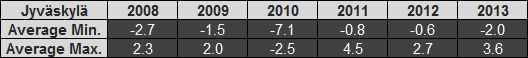
November 2013 Review - Jyväskylä
2013's edition of November was rather warm in Jyväskylä with above average maximums and an overall above average average temperature (i.e. average of all minimums and maximums). The average minimum was cooler than the previous two years though. The table below details the averages since 2008.
The average maximum for November was the second warmest in the past 6 years, whereas the average minimum was almost in the middle, the third coldest. The difference between the minimum and maximum average is actually the highest of the last 6 years, further highlighting the up and down temperatures I referred to in my previous post.
If we look at averages over a longer period, the Finnish Meteorological Institute has an average average temperature for November in Jyväskylä of -2.0C between 1981 and 2010. This year's figure according to my numbers was 0.8C. This is lower than 2011 and 2012, but still well above the long term figure.
The highest temperature for November was 7.9C, recorded on the first day of the month. This was pretty normal if we look at the previous 5 years. The highest minimum of 4.3C occurred on November 16, a day before the storm known as Eino hit Finland.
The lowest temperature was, not surprisingly, later in the month, -13.3C on November 26. Only 2010 had lower minimums than that in the 2008 to 2013 period. The day before that, the 25th, was responsible for the lowest daily maximum, -1.6C. This was actually the highest of the past 6 years, as shown in the graph below.
As mentioned above, Eino hit Finland on October 17. It brought damaging winds to most parts of the country. Coastal locations in the south and west, as well as inland locations in Eastern Finland, experienced the strongest winds. According to FMI, Jyväskylä experienced a strongest gust of 19.2m/s. This wasn't quite as strong as the 32.9m/s (118km/h) gust at Kaskinen on the west coast. There were a few other windy days this month, notably November 5, 18 and 28.
Rainfall was above the 1981-2010 average. There was 75mm recorded compared to the average of 54mm. November 4 and 5 contributed a large amount to that total with 30mm recorded across those two days. Snow also fell a few times towards the end of the month. November 21 saw heavy falls with almost 10cm. Plus temperatures have caused most of it to melt away, but there was still a small amount of snow on the ground at the end of month.
 |
| November averages in Jyväskylä for the period 2008-2013 |
The average maximum for November was the second warmest in the past 6 years, whereas the average minimum was almost in the middle, the third coldest. The difference between the minimum and maximum average is actually the highest of the last 6 years, further highlighting the up and down temperatures I referred to in my previous post.
If we look at averages over a longer period, the Finnish Meteorological Institute has an average average temperature for November in Jyväskylä of -2.0C between 1981 and 2010. This year's figure according to my numbers was 0.8C. This is lower than 2011 and 2012, but still well above the long term figure.
The lowest temperature was, not surprisingly, later in the month, -13.3C on November 26. Only 2010 had lower minimums than that in the 2008 to 2013 period. The day before that, the 25th, was responsible for the lowest daily maximum, -1.6C. This was actually the highest of the past 6 years, as shown in the graph below.
 |
| Lowest maximums in November for the period 2008-2013 |
As mentioned above, Eino hit Finland on October 17. It brought damaging winds to most parts of the country. Coastal locations in the south and west, as well as inland locations in Eastern Finland, experienced the strongest winds. According to FMI, Jyväskylä experienced a strongest gust of 19.2m/s. This wasn't quite as strong as the 32.9m/s (118km/h) gust at Kaskinen on the west coast. There were a few other windy days this month, notably November 5, 18 and 28.
Rainfall was above the 1981-2010 average. There was 75mm recorded compared to the average of 54mm. November 4 and 5 contributed a large amount to that total with 30mm recorded across those two days. Snow also fell a few times towards the end of the month. November 21 saw heavy falls with almost 10cm. Plus temperatures have caused most of it to melt away, but there was still a small amount of snow on the ground at the end of month.
Monday, 2 December 2013
Snow and wind in Jyväskylä, cool weekend in Sydney
A good amount of snow fell in Jyväskylä over the weekend. Saturday saw the biggest falls before more snow arrived on Sunday morning and again in the afternoon. The Jyväskylä weather station in Tikkakoski currently has a reading of 4cm, but there appears to be slightly more than that outside. If it weren't for temperatures pushing above zero yesterday there would be more.
Saturday was only the 4th day of November entirely below zero, reaching -0.6C. December started off yesterday with the kind of temperature you'd prefer not to see here at this time of year, reaching 1.0C. Temperatures declined yesterday afternoon as strong northerly and northwesterly winds made their way east across Finland. I saw a wind gust recording of 19m/s (68km/h) at 6:20pm, which was stronger than the strongest gust from last Thursday's brief snow storm. It was -12.3C this morning thanks to those cold northerlies and clear skies.
Temperatures in Jyväskylä during the last several days have been a bit like a yo-yo. A few low pressure systems have been moving east through the northern half of Finland in the last week, resulting in a combination of cold and warm air. Northerly winds have been blowing cold air from the Arctic, but westerly and southwesterly winds are resulting in warmer temperatures. The next few days will see a similar pattern. It should rise to 2C tomorrow, but drop below -10C in the early hours of Wednesday before reaching only -6C in the afternoon.
It has still been relatively cool in Sydney. November ended with another day below average, getting to only 21.6C. December didn't start too differently, getting slightly warmer and reaching 22.7C. Today has been warmer though going above 25C to 25.6C. Daily minimums were also below average during the weekend, with Saturday's 14.4C helping to drop November's average minimum further. Sunday's minimum was also below 15C at 14.9C.
There isn't anything too spectacular showing in Sydney's forecast for the next week. Fairly average weather is expected with Wednesday being the pick of the next few days with sunny conditions and a predicted top of 29C.
 |
| A good amount of snow fell in Jyväskylä on November 30 |
Saturday was only the 4th day of November entirely below zero, reaching -0.6C. December started off yesterday with the kind of temperature you'd prefer not to see here at this time of year, reaching 1.0C. Temperatures declined yesterday afternoon as strong northerly and northwesterly winds made their way east across Finland. I saw a wind gust recording of 19m/s (68km/h) at 6:20pm, which was stronger than the strongest gust from last Thursday's brief snow storm. It was -12.3C this morning thanks to those cold northerlies and clear skies.
 |
| Sun greeting Jyväskylä this morning as the thermometer read -8C |
Temperatures in Jyväskylä during the last several days have been a bit like a yo-yo. A few low pressure systems have been moving east through the northern half of Finland in the last week, resulting in a combination of cold and warm air. Northerly winds have been blowing cold air from the Arctic, but westerly and southwesterly winds are resulting in warmer temperatures. The next few days will see a similar pattern. It should rise to 2C tomorrow, but drop below -10C in the early hours of Wednesday before reaching only -6C in the afternoon.
It has still been relatively cool in Sydney. November ended with another day below average, getting to only 21.6C. December didn't start too differently, getting slightly warmer and reaching 22.7C. Today has been warmer though going above 25C to 25.6C. Daily minimums were also below average during the weekend, with Saturday's 14.4C helping to drop November's average minimum further. Sunday's minimum was also below 15C at 14.9C.
There isn't anything too spectacular showing in Sydney's forecast for the next week. Fairly average weather is expected with Wednesday being the pick of the next few days with sunny conditions and a predicted top of 29C.
Subscribe to:
Posts (Atom)